
This is a web page version of a report from Living Streets, which is also published as a pdf document. This version has been adapted to focus on providing accessibility for people who want to enlarge the text or to use a screen reader.
The key information below is taken from the document cover pages:
Document title: Inclusive design at bus stops with cycle tracks: Appendix 1 (Detailed study sites)
Document date & version: October 2023, Version 1.3.3
Publishing organisation: Living Streets
Author/research lead: Robert Weetman
Ten junctions were chosen for much more detailed study, referred to as ‘detailed-study sites’. This appendix provides more information about each of these detailed-study sites.
In this webpage version of the report the table in the original document has been converted into a list to aid accessibility. Each line in the following list provides a reference, the city and name we gave the bus stop, its type, and links to Google Streetview and Openstreetmap.org
BS-38, Cardiff, Kingsway , Streetview link, Openstreetmap link, Type – other
BS-622, Cardiff, Newport Road, Streetview link, Openstreetmap link, Type - other
BS-631, Glasgow, Garscube Road, Streetview link, Openstreetmap link , Type - bypass
BS-133, Glasgow, Victoria Road , Streetview link, Openstreetmap link, Type - bypass
BS-139, Glasgow, Sauchiehall Street, Streetview link, Openstreetmap link, Type - bypass
BS-77, London, Whitechapel Road, Streetview link, Openstreetmap link, Type - bypass
BS-67, London, Mile End Road, Streetview link, Openstreetmap link, Type - bypass
BS-86, London, New Bridge Street at Blackfriars, Streetview link, Openstreetmap link, Type - bypass
BS-184, Manchester, Oxford Road , Streetview link, Openstreetmap link, Type - bypass
BS-190, Manchester, Wilmslow Road, Streetview link, Openstreetmap link, Type - bypass
Each site was studied by Living Streets researchers in person, and using fixed cameras.
What follows includes a description of each individual site, a short description of observations, photographs and path trace images.
(near Dalhousie Street)


(3D model includes data © Crown copyright 2023, OS 100046668)
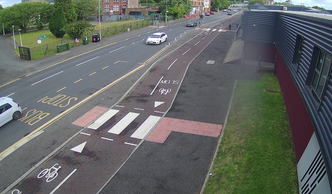
This bus stop is in the centre of Glasgow, on Sauchiehall Street, which contains many shops, restaurants, and other similar establishments, and which is also a very busy pedestrian route (for wider reasons).
The street carries one-way traffic with two lanes, although parking and/or stopping is allowed on both sides of the carriageway meaning there was usually only a single lane of moving vehicles (which slaloms between stopped vehicles).
The cycle track is two-way and at footway level. There is a slightly raised strip separating the two (intended to be detectable by blind or partially sighted people).
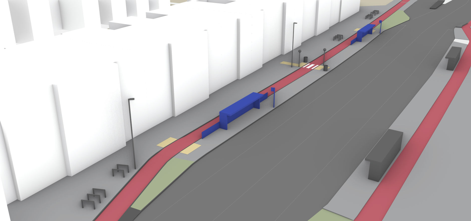
The bus stop is on a long multi-use island. The cycle track is straight.
There are several changes in cycle track colour, and the distinction between track, footway and carriageway is unclear at the nearby side road entrance (see the accompanying report on continuous footways in which a similar neighbouring junction was studied).
There are two zebra crossings. Access to/from the bus stop from the eastern zebra crossing (to the right in the images above) is blocked by an advertising panel on the shelter. There is an entrance/exit through the back of the bus shelter itself (with no associated crossing).


Background mapping © Crown copyright 2023, OS 100046668
This is a busy-complex environment. Although cycling levels are relatively low, levels of pedestrian use of the street are high. Groups or pairs of pedestrians are quite common. As can be seen in the path trace diagram overleaf, many pedestrians (traced in green) are crossing the street. While most pedestrians stay off the cycle track, it is common to see pedestrians walking for lengthy periods along it, standing on it, or crossing it very slowly.
This behaviour was studied in more detail, on 100m of the track, for a 10 minute period. The length of time during which any part of the track was obstructed was estimated in seconds. For longer periods of obstruction, a watch was used to increase timing accuracy.
The table below records the result, with ‘p’ signifying the presence of at least one pedestrian on the track, and ‘c’ signifying a car or other vehicle sitting across the track (at the exit of Dalhousie Street).
| Seconds | 4 | 3 | 30 | 4 | 2 | 6 | 8 | 10 | 24 | 3 | 23 | 4 | 15,7,3 | 3 | 7 | 85 | ||
|---|---|---|---|---|---|---|---|---|---|---|---|---|---|---|---|---|---|---|
| Obstruction | p | c | p | p | p | p | p | p | p | p | p | p | p,c,p | p | p | p(c) |
This equates to this short section of the track being obstructed for 40% of the 10 minute period. That can be visualised in a simplified way – with green indicating unobstructed periods, and yellow obstructed periods – as shown below:

(Note that this is a simplified diagram in which we assume that unobstructed time was equally distributed – which is close enough to the truth to mean that the diagram is not misleading.)
The whole track is around 580m long (nearly six times this section). Thus, it seems likely that most cyclists encounter pedestrians on the track as they cycle along it.
A collision was observed between a slow-moving cyclist and one of the bollards sited in the centre of the cycle track. His handlebar hit this, and he came off the saddle, but fortunately did not fall to the ground.
The main bus stop entrance/exit is through the back of the shelter. There is no indication to cyclists highlighting the presence of this entrance/exit, and exiting pedestrians are hidden from westbound cyclists (travelling gently downhill and passing immediately outside the shelter) by an advertising panel.
One of the zebra crossings is to an area of the multi-use strip which is on the ‘wrong’ side of the advertising panel and looks to have been intended to provide support to cross the whole carriageway, but there is no corresponding zebra crossing of the carriageway itself.
Many pedestrians can be seen to walk along the back of the bus shelter, on or immediately beside the track.
We saw nobody cycling on the carriageway (it is possible that we missed individual instances of this in the recorded footage, but use was rare enough to be insignificant).
Background image

Bicycles

Pedestrians

(near Corn Street)


(3D model includes data © Crown copyright 2023, OS 100046668)
Garscube Road appears to provide a major route for vehicles to and from the northwest of Glasgow city centre. Nearby it is possible to connect to and from the M8 motorway.
The cycle track carries two-way cycling. For most of the nearby length of carriageway there are three lanes for vehicles.
While there are some local shops, the buildings on either side of the road generally provide faceless frontages, lacking windows, being set back from the road, or being placed far behind fences. The closest neighbouring building has an industrial looking frontage, with the closest door to the street being a windowless fire exit.
There is a zebra crossing on the track, properly marked with blister-style tactile paving. The ‘tail’ of this extends to the edge of the pavement, providing a means to identify the crossing location (and the bus stop).
The cycle track is set below the pavement, with reduced height ‘forgiving’ kerbs (angled face rather than vertical face).


‘e’ indicates estimated dimension Background mapping © Crown copyright 2023, OS 100046668
‘
This is a quiet-simple environment. There are low numbers of pedestrians, walking/travelling mostly on a simple route along the pavement. There are relatively low numbers of cyclists, usually cycling alone.
There is excellent visibility, with little or nothing blocking the views of/by pedestrians of/by cyclists. Interactions between pedestrians and cyclists are easily predicted, giving both a great deal of time to adapt behaviour.
It was relatively common to see pedestrians walking along the cycle track.
The signalised crossing (i.e. with traffic lights) around 50m north of the shelter introduces some pedestrian behaviours that would otherwise be absent. It was very common for pedestrians, who had used or intended to use the crossing, to walk along the island at the bus stop or signals, stepping onto the track and walking along the edge of this at the point it becomes narrower. Such behaviours were seen even in pedestrians who would have had an easier time crossing to the normal pavement, for example while pushing a child’s buggy.
This behaviour can be seen to show up in the (green) path trace image below.
All, or almost all, cycling is on the cycle track. There appears to be a little use of the carriageway by north(east) bound cyclists (at an insignificant level, but showing up on the path trace image below – in blue). Sections of the track to the south are on pavements, and so this carriageway usage may be by cyclists who want to travel much faster than this pavement usage would allow - and who have no practical means to cross to the cycle track at this point.
Background image
Bicycles

Pedestrians

(at Pollokshaws Road)


(3D model includes data © Crown copyright 2023, OS 100046668)
Note that the road layout at this location is challenging to describe because two near-parallel roads come close together at the bus stop, but without passage of vehicles from one to the other. There are also two separated sections of Pollokshaws Road, one on each of these (unconnected) carriageways.
We describe this bus stop as being on Victoria Road (the name changes to Pollokshaws Road at or immediately north of the stop).
The relationship between neighbouring buildings and Victoria Road at this point is relatively complex, for example with a petrol station sitting close beside the stop, but with vehicle access to this being only from the other road (to the west of Victoria Road).
There are many stretches of Victoria Road here which lack building frontages.
There is a signalised crossing of the carriageway from the bus stop island to a substantial island of pavement sitting between the carriageway and the cycle track on the opposite side of the carriageway.
The cycle track is below pavement height. There are forgiving kerbs (angled rather than vertical face) to the left of the track (i.e. relative to the direction cycled). To the right the kerbs are of a lower-than-standard height, but these have a vertical face.
The cycle track climbs gently to pavement height at three zebra crossings. Only one of these crossings is more obviously associated with the bus stop itself – with the other two close beside the signalised crossing.
At one area there is level access between cycle track and footway for a longer stretch (perhaps 15m). Here, a single line of corduroy-style tactile paving tiles marks the edge of the track. (It seems clear that design decisions here related to a wish to avoid zebra and signalised crossings lining up.)


Background mapping © Crown copyright 2023, OS 100046668
The northbound cycle track (passing this bus stop) is on a downwards slope. Although this is relatively gentle it can add to cyclist speed.
This was a relatively quiet-simple environment, with relatively low numbers of pedestrians, bus users, and cyclists. In general, there is good visibility of oncoming cyclists, and predictable pedestrian behaviour.
There appears to be a problem caused by the presence of the advertising panel to the north end of the bus shelter (sitting beside the front of the bus with the green roof in the above images). A proportion of pedestrians were observed, on alighting from a bus, to squeeze around this panel, crossing the track on a route northwards. This meant that they crossed the track at the point the track bends back toward the carriageway, where it is hidden from cyclists. We observed a few closer interactions between cyclists and pedestrians here, clearly unanticipated by either.
(While it would have been better to avoid this issue arising, it seemed clear to us that as remedial action a very short section of railing alongside the cycle track would move crossing pedestrians a metre or two north, to a somewhat more visible point.)
We observed a pedestrian standing on the track at this bus stop for prolonged periods during at least a 17 minute wait for a bus (our recording began after his arrival, and ended before his departure). It was clear that he understood the status of the track, as he would move from it when cyclists were approaching, but that he felt comfortable to stand in this space.
There was almost no cycling on the carriageway here. There was some wrong-way cycling, and cycling on the pavement, associated with cyclists coming from Eglinton Road – who had no other clear route to join the southbound route. These cyclists would typically cross to the southbound cycle track once they found a location where they could avoid bumping up and down kerbs.
Background image

Bicycles

Pedestrians

(west of Fitzalan Place, westbound)


(3D model includes data © Crown copyright 2023, OS 100046668)
This is a shared platform boarder design (see Appendix 2 for an account of our naming system).
A two-way cycle track has been created through the use of ‘light’ segregation, meaning that cyclists are using what was previously the carriageway surface.
In the images above, the track is shown in red, however in reality it is of asphalt. There is, however, an obvious zebra crossing highlighting the presence of the shared platform boarder.
There is a white line marking the edge of the cycle track, providing a small area for pedestrians to step onto on alighting from a bus.


Background mapping © Crown copyright 2023, OS 100046668
Due to its small size, it was clear that the shared platform boarder was not part of the ordinary pavement.
The main report includes an account of our main observations at this bus stop.
Key points include:
Most passengers alight here.
Cyclists don’t cycle in the narrow painted strip beside the carriageway. This means that as people step from the bus they can be seen before stepping into the cycle track.
Background image

Bicycles

Pedestrians

(north of Queen Street, northbound)


(3D model includes data © Crown copyright 2023, OS 100046668)
This location is a short distance north of busy city centre shopping streets. There are three associated bus stops (the first two closer together). Buses are travelling away from the centre.
There is no ‘active’ building frontage on this side of the street, but rather an area of grass and the outside of castle walls. There are four or five traffic lanes on the carriageway. There are central raised features in the carriageway which are likely to have been included/designed partly to discourage pedestrians from crossing.
We have described the design here as a hybrid between a shared platform boarder design, and a continued kerbside track design (see Appendix 2 for definitions). The cycle track is two-way (bi-directional).
In the images above, the whole track is coloured red. In reality, as seen in the photographs below, the main track is of grey asphalt, lightly segregated from the carriageway (i.e. with cyclists on what was previously carriageway surface), whereas the track on the platform area is red.
There is corduroy-style tactile paving marking the edge of the cycle track along its raised length (which is at pavement level) – which is of around 100m. The carriageway here is of around 20m width.


‘e’ indicates estimated dimension Background mapping © Crown copyright 2023, OS 100046668
The footway here is often not wide enough for the number of pedestrians using it.
This appears to have been installed more quickly, as a temporary measure (i.e. which might be replaced with more permanent infrastructure later).
Most pedestrians stay clear of the cycle track, except when boarding. Almost all passengers board rather than alighting here. There are times when the number of waiting passengers obstructs the pavement, so sometimes pedestrians walk along the cycle track as a result – typically close to the bus shelters rather than in its middle. Larger numbers of passengers can board a bus – for example 10 or 25.
Most buses stopped with their doors at the zebra crossing markings. Pedestrians then queued across the crossing, blocking the cycle track. This could sometimes be for several minutes (e.g. 3-4 minutes). On occasion a second bus stopped behind a first, with boarding passengers walking along the cycle track to approach it. Passengers could be seen to move onto the track to queue, anticipating the arrival of a bus seen to be waiting at the traffic signals (encountered by the bus driver prior to arrival at the stop).
Cyclists were seen to adopt different behaviours when there were people queuing across the track. Many adopted a very slow pace, making it clear that they wished to continue by approaching the queue, continuing once pedestrians made a space for them to do so, or stopping if necessary, ‘scooting’ using their feet on the ground if the necessary speed required that. Occasionally someone cycled around the back of the bus stop. Even more rarely, someone could be seen to stop, dismount, and walk around the queue. Some cyclists use the carriageway instead in these circumstances.
There was little checking for cyclists by those queuing (the first person in a queue might look).
Background image

Bicycles

Pedestrians
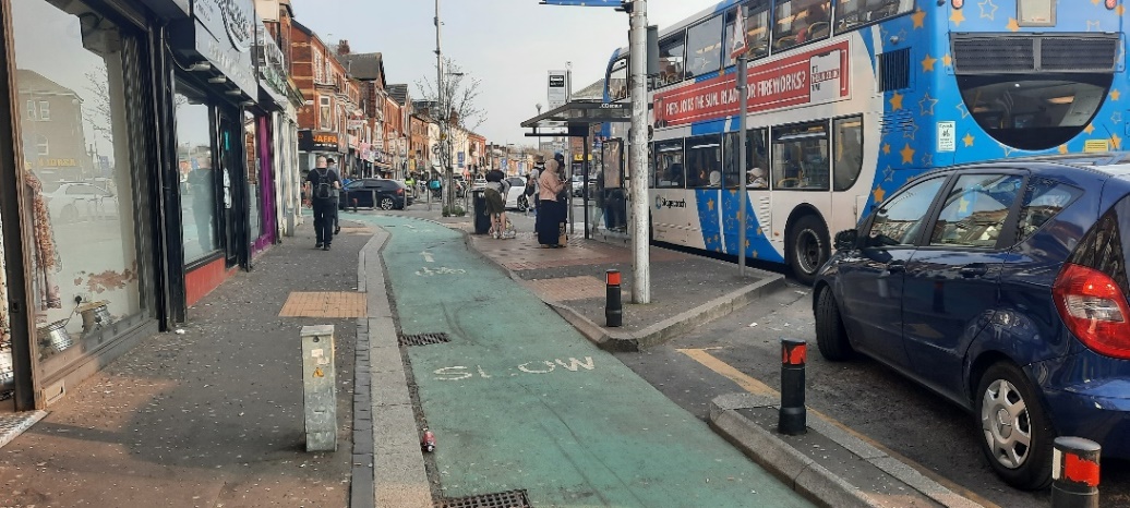
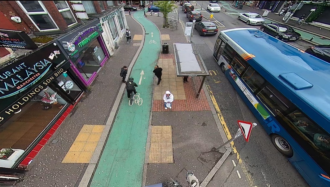
(north of Denmark Road, northbound)


(3D model includes data © Crown copyright 2023, OS 100046668)
This appears to be on an important route between the city centre, hospital, university, and residential areas. However, use of the carriageway at this point is restricted to taxis, buses and permit holders (6am-9pm).
There are several smaller shops beside the bus stops.
There are two bus stops on a long island.
There are three places where the cycle track is raised to pavement level to provide kerb-free crossing points. One of these crossing points is marked with a zebra crossing, which (unusually) includes ‘Belisha’ beacons. This is marked in a standard way with tactile paving – although the ‘tail’ of this does not reach the building line. The other two crossing points lack any zebra markings – and have standard tactile paving marking the absence of the kerb.
There are short sections of railing (i.e. 2-4m) which prevent pedestrians from crossing the track immediately beside the bus shelters.
Kerbs are around 80mm high with a vertical face.
There are areas of planting at either end of the bus stop island which have some influence on the available pedestrian routes.
There are three rumble strips on the cycle track 4.5-6m ahead of the uncontrolled crossing points, and “look left”/”look right” is painted on the track for pedestrians to read.
There are three rumble strips on the track 4-5.5m before the zebra crossing, and a bollard with a small give way sign on it around 2m before it. The rear of this, and a second bollard have ‘look for cyclists’ written on them.
The cycle track is one-way. It is visually distinct from the pavement and island. There are coloured LED lights along the edge of the cycle track, but we did not visit at night to observe these.


Background mapping © Crown copyright 2023, OS 100046668
Sightlines vary here. At the second stop they are very good, as they are at the zebra crossing. Views of the first are more obstructed by signage (including a cycle counter), vegetation and the bends in the track.
The short sections of railing help to distinguish crossing pedestrians from waiting passengers.
Pedestrians tend not to stand obstructing the track.
This is a very busy environment, with many pedestrians.
An advertising ‘A’ board (for Greggs) reduces width on the pavement, as do trees – however pedestrians were regularly seen to walk between the trees and the cycle track – stepping on the grating around the trees.
The railings which prevent pedestrians from crossing immediately beside the bus shelter seem to play a useful role in improving visibility and making crossing pedestrians more obvious to those cycling through the stop area. It was notable that the most northern railing, north of the second (northern) bus stop, was much shorter – and that this reduced its effectiveness in that regard.
Because the carriageway has restricted access, traffic conditions on this were calmer than its width might suggest would be the case. There is a substantial gap in the cycle track before the bus stop area (associated with a side road entrance/exit), and an easy route back onto the track after the bus stop. A much higher proportion of cyclists chose to stay on the carriageway here in comparison to at other sites, with this varying from 15% to 38% across different observed hours.
The graph below charts the percentage of cyclists on the carriageway against the number of cyclists passing (northbound) in an hour. This shows that as the number of cyclists rose, the percentage staying on the carriageway rose, stabilising at around 30-40%. When cycling levels were much lower, the percentage using the carriageway was only around 15-20%
The graph below charts the distribution between cyclists on the track and cyclists on the carriageway across observed study hours (NB: observation stopped after 19:00 and restarted at 07:00, meaning that evening/night hours are missing in this graph).
The path trace diagrams below show the relatively high proportion of cyclists using the carriageway (blue traces).
There are sections of cycle track which are not fully protected, for example at junctions. It seems likely that this may limit cycling on this route to those with some level of comfort mixing with traffic on a main route.
There are sometimes multiple buses stopping at the island e.g. 2-4
As can be seen in the path trace image below, there were high numbers of pedestrians crossing the carriageway here.
Background image

Bicycles

Pedestrians

(at Park Crescent)


(3D model includes data © Crown copyright 2023, OS 100046668)
This site is on a radial road, around 3km from Manchester city centre. The surrounding area is primarily residential, but Wilmslow Road in this area is lined with shops, restaurants, and similar establishments.
Wilmslow Road carries two-way traffic.
The cycle track is one-way.
The cycle track is at a lower level than the pavement. Kerb design varies, with sections lower and with an angled face, others low but with a vertical face, and others higher.
The cycle track has a consistent green colour along its length – which is maintained at places where it becomes a cycle lane (lacking separation from the carriageway).
There is no zebra crossing to this bus stop, but two places where dropped kerbs provide kerb-free access across the cycle track.
Immediately after the bus stop the cycle track crosses the end of a side road, at a point inset into the side road. There are road markings to indicate that cyclists should be given priority here, and the green surface is continued across the carriageway.


Background mapping © Crown copyright 2023, OS 100046668
This is a busy-complex environment which provides challenging conditions for cycling, and multiple obstructions for pedestrians. The Living Streets researcher described conditions as “hectic”.
There are high numbers of pedestrians, and an inadequate width of pavement for this level of use (generally less than 2m width). There are high numbers of pedestrians crossing the carriageway, or engaged in other activity such as loading or unloading from vehicles. Pedestrians are walking immediately beside the track, and often being forced to encroach on it, with some walking along it. There can be a queue for a cash machine blocking the pavement just before the bus stop (e.g. one person waiting on the outside edge of the pavement, while one uses it at the building line, with just enough space for someone walking to pass between).
Space has been provided for parking vehicles in bays which are separated from the track with narrow raised areas of kerbing. Pedestrians sometimes step onto the track from between the parked vehicles. There are a very high number of bollards, employed to restrict parking, and other obstacles close to the track such as a post box, lamp posts, advertising boards, and sign posts.
There are numerous wiggles in the track. Kerb height is a hazard to cyclists in places. There are regular interruptions of the track at side roads, meaning that cyclists are likely focused on their own safety at these points.
While in theory there are clear sight lines, the degree of visual complexity, and the number of people present, means that both pedestrians and cyclists may be focused only on matters immediately relevant to their progress or safety – not anticipating interactions further ahead.
Occasionally two buses would be stopped at once, with some buses allowing passengers to board/alight from/to the carriageway as a result. The area around the bus stop can be crowded with passengers. Some alight from one bus and then immediately board another.
The path trace images below show (in green) the level of pedestrian use/encroachment on the cycle track – and that almost all cyclists (traces in blue) use the cycle track.
The chart below compares use of the carriageway to use of the cycle track (cyclists in each study hour). NB: Unlike other sites, counts here are between 13:00 and 01:00 (with a gap 02:00-13:00).
Background image
Bicycles

Pedestrians

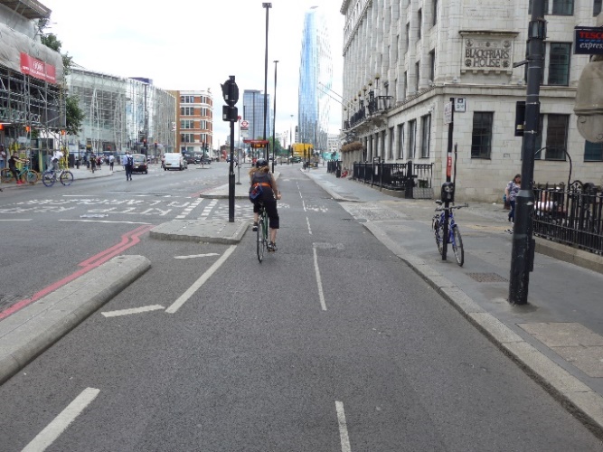
(New Bridge Street south of Tudor Street)


(3D model includes data © Crown copyright 2023, OS 100046668)
This location is in central London (City of London).
New Bridge Street is the A201. It carries two-way traffic. There are typically three vehicle lanes in this area (could be counted as four beside the bus stop).
There is a large and very complex road junction (or set of interconnected junctions) immediately to the south of the bus stop.
The cycle track carries two-way cycling.
There are relatively small side roads immediately at either end of the bus stop island (with the presence of these defining the ends of the island).
The cycle track is at carriageway level, but separated from this by permanent infrastructure (i.e. this is not ‘light’ segregation).
There is a gentle hill sloping toward the bus stop from the north, which is significant enough to increase cycling speeds on approach – but the effects may be relatively minor.
There is no zebra crossing marked on the cycle track. At one location the cycle track is raised to pavement level, and a lighter surface material applied to the cycle track. This is marked with triangular ‘ramp’ markings on the cycle track.
In dry weather there is a relatively high degree of visual contrast between the pavement (and island) and the cycle track. The ordinary pavement is of a lighter asphalt. The surface of the island is surfaced with flags.


Background mapping © Crown copyright 2023, OS 100046668
This location was chosen because we suspected the cycle track to be one of the busiest in Britain. There are very high levels of cycling on this track, and very high levels of pedestrian use of the pavement.
The presence of the cycle track is made obvious by its width and the use of relatively high kerbs (100-130mm) – although these introduce hazards of a pedal strike for cyclists. The level of use of the cycle track also makes its presence obvious.
The kerbs to either side of the cycle track are often with an angled face, but it seems unlikely that this provides any great advantage to cyclists due to their height (in comparison to more ‘forgiving’ lowered kerbs with an angled face).
Although there are triangular ramp markings indicating the rise in the cycle track surface, the ramps here are very gentle, and warning of their presence seems unnecessary. Combined with the bicycle symbols, it is possible that many interpret these as arrows indicating two-way use of the track.
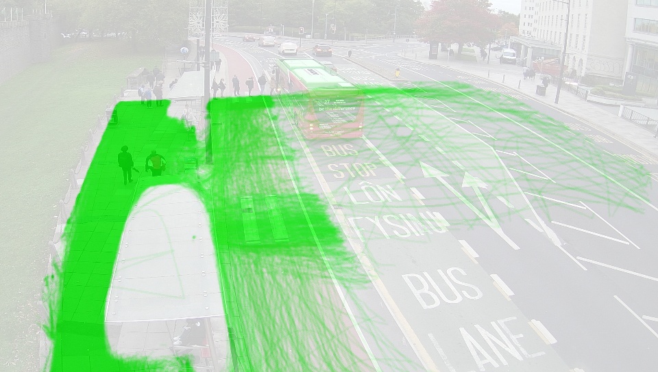
We were surprised by the number of pedestrians crossing the carriageway here, using the bus stop island to shorten the crossing distance. Other pedestrians are seen to walk along the island on route to/from the signalised crossing of New Bridge Street which is located immediately south of the bus stop.
This was the only cycle track in the study where we observed a pedestrian wait for more than 10 seconds to cross a cycle track (using recorded footage taken over many hours, including at peak usage times). In footage here of over 200 people crossing, taken at morning and evening peak times, one pedestrian waited for 48 seconds, around 4% waited for 20 seconds or more, and around 1.5% for 30 seconds or more.
It was obvious, as shown in two of the photographs above, that traffic exiting Tudor Street, immediately north of the bus stop, often created challenges for those cycling.
At other busy cycle tracks we cycled on there were sometimes situations when we were in a group of strangers. This was the only site where we would describe that we were part of a full flow of cyclists, by which we mean a situation where groups merge, and that most cyclists here have other cyclists close ahead and close behind (and often close beside). This created a situation for cyclists which was quite unlike that at other cycle tracks (in the same way that happens for drivers on roads where a full flow of vehicles exists). More details are given in the main report.
The path trace images below show that pedestrians (green traces) do not generally walk on the cycle track, and that there is very little cycling (blue traces) on the carriageway (and none was detected on the pavement).
Background image

Bicycles

Pedestrians

(Altab Ali Park stop)


(3D model includes data © Crown copyright 2023, OS 100046668)
This location is in central London, at the west of the London Borough of Tower Hamlets. Whitechapel Road is one part of a much longer major road (becoming Mile End Road, where another detailed-study site is found).
The carriageway here typically has three or four vehicle lanes (often one or two being a bus lane).
The cycle track carries one-way cycling. On the overall route it changes from being a cycle track to a cycle lane (painted on the normal carriageway) on many occasions. For most of the length of the track/route it has a blue surface.
The cycle track is at carriageway level, usually with full height kerbs to either side.
There is a zebra crossing marked on the cycle track. the track rises to pavement height at this location. This is marked with standard tactile paving on the pavement, but the ‘tail’ of this does not reach the building line.
Parking and stopping on the carriageway are restricted, but a loading area is marked on both sides of the carriageway here (this was seen to be used regularly).
There are shops and restaurants, and similar establishments, along this stretch of pavement.


Background mapping © Crown copyright 2023, OS 100046668
There were high levels of cycling here (the second highest level of all our detailed-study sites), and it is clear that this is on an important route for cyclists.
The character of this route, for cycling, is defined by the intermittent nature of the cycle track. Cyclists are often on a painted cycle lane, a bus lane, or on the edge of the normal carriageway. It was common to find that we were cycling with strangers in a group on parts of this route, often because a group forms while individual cyclists wait at a junction. The narrow width of the cycle track, particularly at bus stops, was a challenge in such circumstances – with considerable focus required to anticipate and deal safely with narrowed sections, and kerbs on bends at pedal height. There are also many side road entrance/exits – at which point protection from vehicles is minimal (generally a painted cycle lane only).
As can be seen on the path trace images below, an unusually high proportion of cyclists (blue traces) remained on the carriageway at the bus stop – many transitioning easily on and off the painted cycle lanes to either side of it. We observed many other uses of the track and carriageway. For example with e-scooters or other battery powered devices.
The loading area marked beside a section of the bus stop island was regularly used, as was another on the far side of the carriageway. Use was lower, but continued, outside the allowed times.
At times there were considerably more people cycling past the stop, than walking past or than vehicles passing. For example, in a 10 minute period at 08:40 on a weekday there were 90 cyclists, 65 pedestrians, and 67 vehicles (all only westbound numbers). Shortly before this, at 08:25, over a 10 minute period, we estimated that 19 people passed (westbound) in private cars, 9 in taxis, 2 on motorbikes, 45 in work-related vehicles, and 107 on 5 buses (the number of passengers is only a rough estimate taken as a bus passed). This suggests, broadly, that those travelling by bus, and those travelling by bicycle, were the largest groups, even if all those travelling by (other) motor vehicles were considered one group.
Pedestrians did not stand in the cycle track here, but few showed any concern crossing it.
The pavement was wide enough for the level of use so that we did not generally see pedestrians stepping into the track to pass other pedestrians or to pass obstructions.
The advertising panel on the bus shelter blocks visibility by/of some crossing pedestrians by/of cyclists (shown in an image above). However, few alighting passengers crossed in the location which was hidden by this. It helped that buses have middle exit doors and typically stopped so that these were at or before the bus shelter – meaning that those alighting and turning right/west could easily pass around the left end (from their perspective) of the shelter.
Background image

Bicycles

Pedestrians

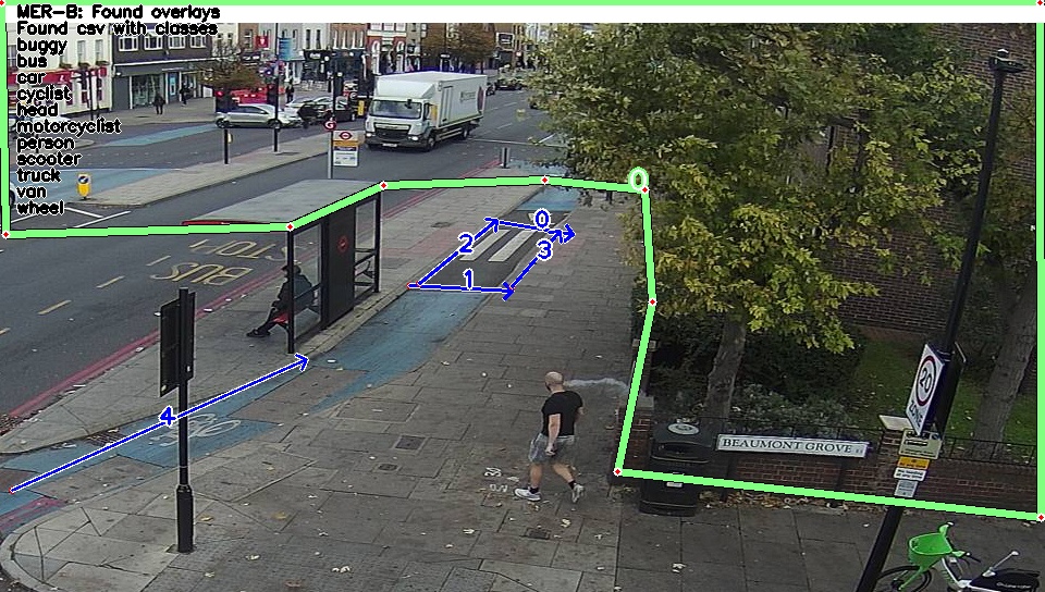
(at Stepney Green Station, westbound)


(3D model includes data © Crown copyright 2023, OS 100046668)
This location is on a major road route into central London. Mile End Road becomes Whitechapel Road further west (where a second detailed-study site is found).
At this location Mile End Road has four vehicle lanes.
As cyclists approach this bus stop (assuming they are already on Mile End Road) they are cycling in a bus lane, then in a painted cycle lane. They cross a major signalised junction (on the ordinary carriageway) into another stretch of cycle lane, pass a signalised crossing, then immediately at the bus stop join a cycle track. Immediately after the bus stop the track again becomes a painted cycle lane (to allow vehicles to exit a side road). After the side road there is the beginning of a lengthy protected cycle track (at carriageway level).
A residential building faces the pavement here.
Close beside the bus stop is a signalised crossing, providing access to a central pedestrian island, and a further signalised crossing to the far side of the carriageway. Stepney Green station is located at the far side of the carriageway.
Kerbs on either side of the cycle track are of up to around 120mm height (sufficient to present a risk of pedal strike by cyclists)


Background mapping © Crown copyright 2023, OS 100046668
As can be seen in the path trace images (below), a relatively high proportion of cyclists (blue traces) stay on the carriageway here, which seems unsurprising given the layout (as described above).
Cyclists often arrive in groups, having been held together at the traffic signals at the junction. They can also arrive at speed, having been unprotected from ordinary traffic on the preceding route. There are high kerbs, and sharp corners on the track, and this is too narrow for two cyclists side by side. Cyclists who stay on the carriageway gain additional distance from the front of any vehicles sitting at the exit of the side road.
It is trivial to join the cycle track immediately after the side road.
For those cycling in the track, vehicles exiting the side road present a risk, and they sometimes block progress (as shown in the first photograph above).
The behaviours adopted by pedestrians crossing the carriageway are of interest, because it was clear that the favoured route (for pedestrians arriving/leaving from/to the east) to cross to a central pedestrian island was by using the bus stop island, rather than by using a signalised crossing. This is described in detail in the main report. In the path trace images below, this can also be seen (traces in green).

(Background mapping © Crown copyright 2023, OS 100046668)
Background image
Bicycles

Pedestrians
