
This is a web page version of a report from Living Streets, which is also published as a pdf document. This version has been adapted to focus on providing accessibility for people who want to enlarge the text or to use a screen reader.
The key information below is taken from the document cover pages:
Document title: Inclusive design at bus stops with cycle tracks: Appendices 2-5
Document date & version: March 2024, Version 1.5
Publishing organisation: Living Streets
Author/research lead: Robert Weetman
The classification of design options – for situations where a cycle track continues past a bus stop – is clearer if it is understood that the ‘bus stop bypass’ versus ‘bus stop boarder’ classification is over simple.
The biggest issue is that the term ‘boarder’ is confusing and is used to refer to quite different designs. A secondary issue is that current classifications tend not to describe ‘hybrid’ designs.
This appendix provides additional ideas about classifying the different possible designs.
NB: This appendix is provided only to support ideas about classification, and does not provide any guidance on the value (or lack of value) of the different options.
This table lists some of the key dimensions which can be combined to create different bus stop designs. The options marked with an asterisk in this table are generally associated with designs known as a ‘bus stop bypass’.
Table 1: Key design dimensions
| Option 1 | Option 1 + option 2 hybrid | Option 2 | |
|---|---|---|---|
| Position of cycle track? | Cyclists pass between the bus stop and the main pavement * | Cyclists pass between different elements of the bus stop and related street furniture | Cyclists pass between the bus stop and the carriageway |
| Waiting area position? | Bus passengers wait on an island of pavement * | Bus passengers sometimes wait on the main pavement and sometimes on an island | Bus passengers wait on the main pavement |
Boarding /alighting position? |
Bus passengers alight onto an island of pavement* | Bus passengers alight onto a small area which isn’t part of the cycle track but which isn’t really a recognisable island of pavement area | Bus passengers alight onto the cycle track |
| Is island only for bus stop? | The island of pavement is distinctly defined, clearly existing to serve the bus stop* | There is a multi-use area which is neither part of the main pavement, nor a larger island of pavement, of the bus stop waiting area is a part | The island of pavement is much larger, continuing outside the area of the bus stop |
| How big is the island? | There is no island of any kind (even a painted area) between track and carriageway. | There is a small area between cycle track and carriageway, not large or significant enough for people to wait on it. | The island is big and significant enough several to wait on it comfortably. |
| Single or multiple bus stops? | The island of pavement serves one distinct bus stop * | There is an area which has a design much like the pavement, joining separate bus stop islands, but which isn’t really wide enough to be walked along | The island of pavement stretches over a longer area, and it serves more than one bus stop |
| Does main footway continue? | Passing pedestrians stay on the main pavement area when passing the stop * | There is only a narrow area of ‘main’ pavement, so many passing pedestrians walk along the bus stop island area (or on the track) | It is intended that all pedestrians cross the cycle track to pass the bus stop area |
| One or two way cycle track? | The cycle track is one-way | The cycle track is marked as one-way, but many people use it in the wrong direction | The cycle track is two-way |
| Can other vehicles pass behind the stop? | The bus stop island is separated from the main pavement by a cycle track | The bus stop island is separated from the main pavement by an access used almost entirely for cycling, but which can occasionally carry a vehicle | The bus stop island is separated from the main pavement area by a vehicle access |
| Who crosses what? | Pedestrians cross an area, whether or not marked with a crossing, which is clearly part of a cycle track * | Cyclists and pedestrians cross an area which feels to be shared equally between pedestrian and cyclist uses | Cyclists cross or pass through an area, whether or not marked with a crossing point, which is clearly intended mostly for pedestrian use |
| Does the cycle track maintain its significance? | The cycle track continues through the bus stop area in an obvious way, with boundaries which are obvious* | Something reminiscent of the cycle track continues through the bus stop area, but in a diminished form, or with boundaries which are unobvious | The cycle track stops and starts for the bus stop, meaning cyclists use an area which feels to be ordinary pavement |
| Is the rest of the cycle track obvious? | There is generally an obvious cycle track, before and after the bus stop area | The cycle track, before and after the bus stop area, has indistinct separation from the pavement | Cyclists are allowed to cycle on the ordinary pavement, before and after the bus stop area |
As discussed in the main report, we propose that in future, there are seen to be four key design types, which are:
Bus stop bypass (or floating bus stop / bypass bus stop)
Shared platform boarder
Continued kerbside track
Broken cycle track
Simplified sketches of these reference types are provided in Figure
1.
NB: Inclusion of these options is only to assist in
naming/classification issues.
Figure 1: Key reference design types
1) Bus stop bypass
2) Broken cycle track (shared pavement)

3) Continued kerbside track design

4) Shared platform boarder design

Table 2 provides links to a variety of real-world designs, demonstrating how much these can vary – and the inadequacy of a simple ‘bypass’/’boarder’/’shared’ classification scheme.
The titles in the ‘type’ and ‘sub-type’ columns are intended informally (i.e. not to imply a formal classification scheme).
Bold entries in the ‘type’ column indicate examples of the key reference design types (as in Figure 1). Other options can be seen as variations or hybrids of these.
Table 2: Google Streetview image links
| Type | Sub-type | Distinguishing detail | Ref | Streetview link |
|---|---|---|---|---|
| Bypass | Simple bypass |
|
BS-129 | https://goo.gl/maps/ELiHQC2RmxFajCUM7 |
| Bypass | Simple bypass |
|
BS-44 | https://goo.gl/maps/oJT6QfvD8FjZHHNB8 |
| Bypass | Simple bypass |
|
BS-86 | https://goo.gl/maps/1X5Jhd5FHv7CeCjd9 |
| Bypass | Extended bypass |
|
BS-139 | https://goo.gl/maps/TjMZnuKgbZoevFPDA |
| Bypass | Double-stop |
|
BS-182 | https://goo.gl/maps/BhPB6j7GMKjEj2n16 |
| Bypass | Pedestrians all use island |
|
BS-245 | https://goo.gl/maps/7y2MB7VYddHNCtKZ6 |
| Bypass-shared hybrid |
|
BS-225 | https://goo.gl/maps/fvhKQubx54cjJ77y8 | |
| Bypass | Separate pavement |
|
BS-15 | https://goo.gl/maps/wQUqaQJZh58R4xo96 |
| Bypass-shared hybrid |
|
https://goo.gl/maps/wQUqaQJZh58R4xo96 | ||
| Vehicle-bypass | Cycle /vehicle bypass |
|
BS-404 | https://goo.gl/maps/MYV3J6xdQNz5uVmf8 |
| Vehicle-bypass | Vehicle bypass |
|
BS-509 | https://goo.gl/maps/81gVGPBB6kU1SCb18 |
| Boarder-bypass hybrid | Bus infra off island |
|
BS-198 | https://goo.gl/maps/c45hqGZLdEuahiD18 |
| Boarder-bypass hybrid | Bus infra off island |
|
BS-111 | https://goo.gl/maps/fxcy6vhzCjYaqTMf7 |
| Boarder-bypass hybrid | Bus infra off island |
|
BS-143 | https://goo.gl/maps/P2hPEAnxSqiMN2C66 |
| Boarder-bypass hybrid | Bus infra off island |
|
BS-530 | https://goo.gl/maps/bR5GavYdMkYfRPKcA |
| Boarder-bypass hybrid | Bus infra split |
|
BS-112 | https://goo.gl/maps/7mtQCDV5vSrRqXcNA |
| Boarder-bypass-shared hybrid |
|
BS-150 | https://goo.gl/maps/nByHn7vKuxG8t6dw5 | |
| Continued kerbside track | Simple |
|
BS-460 | https://goo.gl/maps/reE1rPAJktnRtoWP9 |
| Continued kerbside track | Simple |
|
BS-490 | https://goo.gl/maps/yX9BVvN3Pnt8PQDa7 |
| Continued kerbside track-broken cycle track hybrid |
|
BS-448 | https://goo.gl/maps/jhYMG2vJFm4Aqcik8 | |
| Continued kerbside track-broken cycle track hybrid |
|
BS-476 | https://goo.gl/maps/ozzcRw6i38DNVn3T6 | |
| Shared platform boarder | Simple |
|
BS-386 | https://goo.gl/maps/rF99TgLEmszEcwuW9 |
| Shared platform-continuation of cycle track hybrid |
|
BS-25 | https://goo.gl/maps/vrFYB9Q8vS9EodWG8 | |
| Shared platform - shared area hybrid |
|
BS-309 | https://goo.gl/maps/peSN9n6vWmm825s58 | |
| Shared platform boarder | Simple |
|
BS-622 | https://goo.gl/maps/13ce8TKkC25EfoQr9 |
| Broken cycle track | Simple |
|
BS-313 | https://goo.gl/maps/KbuEfqgwmXebP9Ct7 |
| Other | Bus mounts track |
|
BS-287 | https://goo.gl/maps/9srHRDp511mbU7ad9 |
| Other | Two-way cycling within bus layby |
|
BS-338 | https://goo.gl/maps/JXSJmjhY2yVbHHK59 |
For the convenience of designers, the following list summarises some of the key suggestions made in the main report. The interpretation of these points should be on the basis of the text in the main report (which makes clear which points are more speculative and which are more firmly evidenced).
Alternatives to continuing a cycle track past a bus stop should be chosen if possible.
There should be an acknowledgement that blind and partially sighted people may be disadvantaged by the need to cross a cycle track to access a bus.
A key means to reduce any excluding effects is to significantly increase the overall accessibility of streets in the wider area.
Problems for pedestrians increase according to the level of cycling on the cycle track.
Problems for pedestrians increase as the environment cyclists are encountering becomes more complex, with the level of pedestrian use affecting this.
As a rule of thumb, it is helpful to consider three situations as different from one another, which are those with quiet-simple, moderately-busy-complex, and busy-complex environments.
The following add to the complexity of a situation:
Higher numbers of cyclists, a level of cycling when strangers find themselves in groups, larger flows of cyclists
Two-way cycling
The presence of groups of pedestrians, flows of pedestrians
Limits to space so that pedestrians are close to the cycle track, or so they are likely to stand or walk on the cycle track
A larger number of buses, stopping more frequently, more than one bus stopping at a time
Buses sitting at a stop for a prolonged period
Larger numbers of people alighting from buses, groups alighting from buses
Pedestrians queuing (e.g. for a cash machine, shop, taxis, or for the bus), crossing the carriageway, entering and exiting shops, standing chatting in groups
Breaks in a cycle track in which cyclists are at risk from vehicles
Obstructions and imperfections in surface – including drain covers, slippery metal features, kerbs at pedal height, kerbs with a vertical upstand, steep ramps
Sharp bends in the cycle track (particularly if the track is narrow and if kerbs are high)
Handlebar height (or higher) obstructions close beside the cycle track, even if these aren’t actual collision risks. Bollards in the cycle track.
Cycle tracks should be built so that it is very clear that they are separate from the footway.
This distinction between track and footway should be made obvious for blind and partially sighted people, and more obvious for all other pedestrians, with a drop in level to the track, and the use of kerbs of sufficient height (but which are reliably below pedal height). For the same reason, cycle tracks should be of a consistent colour (and tone – i.e. “light reflectance value”) and this should have a clear contrast with the footway.
Kerbs should be of a “forgiving” design (low enough so as not to risk a pedal strike, with an angled rather than a vertical face). They should be high enough to be detectable by blind and partially sighted pedestrians using a long cane, and with their feet.
For the reasons above it is likely to be a mistake to try to influence behaviours by introducing changes in surface colour on the cycle track (the exception being zebra crossing markings).
Identifiable kerb-free crossing points of the cycle track should be provided, either by raising the track to footway level or by dropped kerbs (from footway to cycle track level). For cycle tracks of a decent width, with forgiving kerbs, there may be little practical difference between these arrangements (as far as the user is concerned).
Tactile paving should be provided (in a standard arrangements) to highlight such points. It should be recognised that some pedestrians will want to avoid walking/wheeling over these.
Zebra crossing markings might be used to highlight the overall presence of the bus stop, and any key crossing points. Crossings with very few stripes, and/or short stripes may not be recognised as formal zebra crossings by many members of the public. Zebra crossings (alone) are unlikely to lead to high levels of priority being provided for crossing pedestrians.
Any zebra crossings should be located at places where most pedestrians are likely to cross, so that they are used rather than ignored.
Accessibility is improved by increasing the space available at the bus stop, particularly when there are likely to be larger groups of passengers waiting for buses, and/or alighting from them.
Crowded environments can cause challenges for disabled pedestrians alighting from a bus. These can be reduced if it is possible for people to leave the bus stop area by more than one route (avoiding the crowd rather than being forced to pass through it).
Excessive crossfall on a bus stop island, which can be introduced because of the combination of high kerbs at the carriageway, and lowered kerbs at the cycle track, should be avoided. It may help to align raised crossings of the cycle track, with the location that bus access ramps are deployed.
The environment around a cycle track can be complex, and an overall objective is to simplify this, ensuring that cyclists are free to look ahead, anticipating the behaviours of any pedestrian likely to cross the track. In order to achieve this:
It is important that the presence of a bus stop is obvious to cyclists.
In a more complex environment crossing pedestrians (or pedestrians wanting to cross) should be made as obvious as possible, to distinguish them from pedestrians who are not doing so.
Small sections of railing and the orientation of the bus shelter might be used to clearly separate waiting passengers from a cycle track, and to separate crossing pedestrians from any crowd at the stop
There should be sufficient width on cycle tracks, so that the attention of cyclists is not on avoiding collision with other cyclists (and decreases in width at the bus stop should not introduce the risk of such collisions).
Kerbs at the edges of the cycle track should be consistently and reliably lower than pedal height (i.e. not only at the bus stop), and of a ‘forgiving’ design (i.e. with an angled rather then vertical face).
Distracting bends in the cycle track should be avoided close to the bus stop area.
With the exception of simple zebra markings, paint markings on cycle tracks should be minimised.
Triangular markings highlighting the presence of ramps should only be used for ramps that are steep and high enough to cause cyclists an unexpected or unobvious hazard, not at less significant ramps.
Pedestrians about to cross the track must not be hidden behind obstacles and must not have their visibility of oncoming cyclists obstructed. Pedestrians might be prevented from crossing at places where they are particularly difficult to see (assuming that a diversion of a few metres makes them more visible).
If it is desired to include features to slow more extreme speeds – such as might arise on a downhill cycle track or with the use of illegally modified e-bikes – then cyclists should finish their negotiation of such features before they need to begin to pay attention to anticipating any potential crossing pedestrians.
Such features should not exclude (or cause pain or discomfort to) users of alternative designs of cycle, wheelchairs, mobility scooters, and other wheeled mobility aids.
Any ‘SLOW’ markings should be used in a manner consistent with its official meaning, and with how this marking is used on a typical carriageway. The official meaning is “Vehicular traffic should proceed with caution because of potential danger ahead”. The marking typically advises of danger to the person driving where this danger is unobvious. It could be used to warn cyclists of the risks associated with negotiating a feature as described in the point above.
Any signage to highlight the presence of a zebra crossing should be with a sign according to ‘Diagram 544’ in TSRGD (a warning triangle showing a crossing pedestrian).
The main report recommends that a set of enhancements – for making it easy for blind and partially sighted pedestrians to cross the cycle track – are researched.
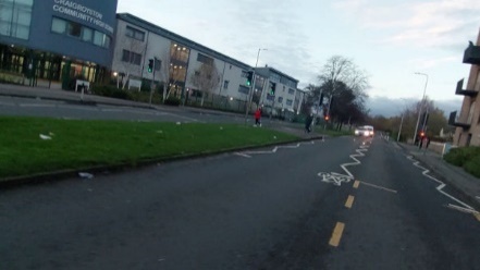
This appendix provides a sequence of 30 images, taken from a helmet-mounted camera, showing a two-minute journey on a cycle track which has gaps at bus stops. There is only “light segregation” from the carriageway, but the experience would be similar on a fully segregated track in which there were similar gaps.
A car is parked in the gap at the first bus stop. At the second the cyclist prepares to pass two buses, but the front one pulls away. At the third the cyclist checks to prepare to pass the front bus, finding the bus behind is pulling in close behind them
00:00 in track

00:02 bus passing

00:09 approaching gap in track

00:12 gap in track for side road

00:14 back in track

00:16 gap in track for crossing

00:17 gap in track for crossing- car parked ahead

00:21 looking behind to prepare to pass car

00:23 car parked in gap at bus stop (beginning to pull out to pass)

00:24 checking behind again
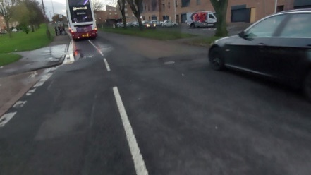
00:26 passing car parked in gap for bus stop (blocked access to track)

00:29 looking for a gap in protection to return to track

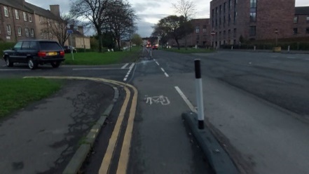
00:32 back in track

00:39 approaching gap for side road and bus stop, buses stopped ahead

00:42 gap in track, predicting need to pass two stopped buses

00:45 Car passing, preparing to pull out to pass buses
00:47 Checking behind and pulling into carriageway, car driving into the side road end behind

00:49 In main carriageway to overtake both buses, but front bus now moving

00:51 Overtaking rear bus, aware in bus driver’s blind spot, front bus now moved away

00:53 Passing front of bus, but may not yet be visible to bus driver

01:00 Back in track

01:15 avoiding drain cover

01:32 Noting bus stopped ahead

01:35 Gap in track for bus stop, bus pulling off from stop

01:55 SUV pulling across path (at speed but with sufficient distance)

01:58 gap in track for side road
02:24 in track (22 seconds since returning to track after gap)

02:32 bus in stop ahead, gap in track, considering need to overtake

02:36 checking behind to prepare to overtake first bus, now aware second bus is following and pulling in close behind, view of carriageway behind this bus is blocked (stressful)

02:38 bus following close behind, but then stopping, view of carriagway getting better, beginning to pull out to overtake first bus (however, the front bus pulled away)

(The gaps in this track to allow for the bus stops were made larger because of there being neighbouring gaps left for the side road entrances, but even without side roads gaps for bus stops must be several times the length of a bus.)
One thread of project activity involved focus groups and site visits with disabled people, as members of the public. These were people involved in the project specifically as members of the public, whereas other disabled people were involved because of a professional or other relevant role. The table below summarises the demographic characteristics of those involved.
Transport for All, who were supporting this thread, sought to recruit people “pan-disability” and across other demographic groups.
These details were provided by the participants themselves and not judged or assessed in any other way.
To view the table please refer to the original pdf version of this report section.