
This is an web page version of a report from Living Streets, which is also published as a 103 page pdf document. This version has been adapted to focus on providing accessibility for people who want to enlarge the text or to use a screen reader.
The report has been produced as part of the Living Streets project “Inclusive Design at Bus Stops and Continuous Footways”. This project is funded by the Scottish Road Research Board (Transport Scotland) and Department for Transport.
The key information below is taken from the document cover pages:
Document title: Inclusive design at continuous footways
Document date & version: September 2023, Version 2.12.3
Publishing organisation: Living Streets
Author/research lead: Robert Weetman
Editing/reviewing/research: Sam Wakeling (research and editing), Emma Pearce (research and field work), Stuart Hay (editing)
We are Living Streets, the UK charity for everyday walking.
We want to create a nation where walking is the natural choice for everyday, local journeys; free from congested roads and pollution, reducing the risk of preventable illnesses and social isolation. We want to achieve a better walking environment and to inspire people of all generations to enjoy the benefits the simple act of walking brings.
By ‘walking’, we include wheeling.
David Spaven, external editorial support
Illustrations (e.g. Figures 6, 16, 18, 25, 26, 28) © Jenny Elliott
We convened a project Reference Group to provide advice and ideas. We’d like to thank its members who are listed below:
Karen Russell, Transport Scotland
Alan Oliver, Transport Scotland
Fiona O’Neill, Department for Transport
Sally Gibbons, Department for Transport
Paul Cronin, Sustrans Scotland (2021-22)
Will Haynes, Sustrans (2023)
Susan Fulton, Mobility and Access Committee Scotland (MACS)
Suzanne Forup, Walk Wheel Cycle Vote
Professor Eva Heinen, University of Leeds (2121-22)
Rurigdh McMeddes, City of Edinburgh Council / SCOTS
Stacey Monteith-Skelton, City of Edinburgh Council / SCOTS (2021-22)
Professor John Parkin, University of the West of England
Caroline Stickland, Transport for All
Sue Sharp, Disabled Persons Transport Advisory Committee (DPTAC)
This report is the work of Living Streets, and the findings it describes are not necessarily endorsed by those listed above, nor any organisations they represent.
Our remit was to answer the broad question: do bus stop bypasses and continuous footways lead to people being excluded from use of the streets (and bus services), and what would make them more inclusive? We have responded to the challenge by seeking to clearly describe the infrastructure (its key characteristics), desired outcomes, and the user experience for people who walk, wheel, cycle or drive. From the beginning, our underlying assumption has been that if infrastructure excludes people or exposes them to increased road danger then it is not performing well.
This infrastructure is being introduced partly in response to national policy objectives to increase levels of cycling and walking. While clearly the product of a policy environment, the observations, conclusions and recommendations in this report are not a definitive statement of Living Streets’ position on bus stop bypasses or continuous footways. In submitting the findings to a wider audience, we hope that this is just the beginning of a much bigger conversation about what changes are needed to make streets more inclusive.
This work is an in-depth investigation relating to the use of continuous footways. It was prompted by questions around whether these make streets more or less inclusive, and whether particular design features make a difference.
To answer these questions, we used a multi-threaded approach over a project spanning two years. This brought together hard data, softer evidence of real-life behaviours, and learning from literature, consultation, focus groups, and interviews. Initial findings were refined through consultation with people with a range of differing views. The result is a set of conclusions which point to a complex and nuanced situation.
The initial report sections and accompanying appendices present the separate elements of evidence and threads of work that support our findings. The “Discussion of core findings” section of the report brings these together, covering the following issues in depth:
Key points in the discussion include that:
There is a very high level of confusion over what is and what is not a continuous footway, how they should be designed, and what their use aims to achieve
Many of the designs being called continuous footways in Britain do not convincingly continue the footway
Most of the designs being called continuous footways in Britain do not provide high levels of pedestrian priority
The use of these designs can create problems not just for some disabled people, but for a wider group
It can be seen that higher levels of pedestrian priority can more easily be established where there are fewer vehicles, travelling at much lower speeds
Structures used in other countries to create continuous footways are also used on footway crossovers (private entrances across a footway), creating a more inclusive design than is used at many British footway crossovers
What in this report we call “real” continuous footways, which unambiguously continue the footway, might be more effective in prioritising pedestrians.
We argue that the unambiguous continuation of a footway, in a “real” continuous footway, will not be sufficient to ensure pedestrian priority, safety, and the inclusivity of a design. We outline, in addition:
A set of necessary design features
A set of limits on where continuous footways could successfully be used.
We provide details on the need for:
The use of physical features which force only low vehicle speeds at the continuous footway (we propose “walking pace” as a rule of thumb)
Low levels of vehicle use of the side road, and the prevention of simultaneous two-way vehicle movement in and out of the side road
Appropriate conditions on both the side road and main road (which we describe).
Some discussion around the use of continuous footways has focused on whether tactile paving should be used, and how this should be laid out.
Recommendations are made complex because they must account for:
The current use of the term “continuous footway” to refer to very different infrastructure designs, used in quite different situations
The current use of designs which fail to provide high levels of pedestrian priority
The equivalence of continuous footways and footway crossovers, in practical terms, in situations where there is very low vehicle use and speed
Questions about future use at “real” continuous footways, where there would be low vehicle use, very low speed and unambiguous pedestrian priority.
We recommend the retro-fitting of standard tactile paving where designs mean pedestrians are not being provided with unambiguous priority, and where they need to respond to risks from vehicles to maintain their safety.
We describe a more complex set of factors to take account of in relation to the use of tactile paving in other situations. Some of these relate to broader navigational challenges, not only questions about pedestrian priority.
We suggest alternatives to standard arrangements could be trialled at sites providing unambiguous pedestrian priority, where/when these exist, as part of a programme seeking a nationally standardised approach.
We observed that to some extent designers and organisations representing disabled people might share overall objectives, while being divided into two different camps, with a lack of connection of knowledge-sharing being a significant problem.
It was evident that many concerns about current designs were valid, and have not been sufficiently heeded. However, it was also evident that there is a real risk that opposition to more radical change, from those who have experience of their needs being ignored, may help to entrench the status quo of traffic dominance and low pedestrian priority, making good quality changes less likely.
We recommend that those interested in progress and on improving conditions for pedestrians should build allegiances, connections, and real in-depth knowledge, lessening the divide between designers focused on implementing changes and organisations representing disabled people concerned about them.
Overall this work points to some bigger questions around how streets should be designed.
We suggest that the successful use of continuous footways, and the success of many alternative means to improve conditions for pedestrians, will depend on a greater level of reform of our streets.
This report sets out the results of research carried out by Living Streets into continuous footways. These can be described as infrastructure designs intended to provide enhanced priority for people walking and wheeling1 by continuing the footway (i.e. the pavement) of a bigger road over the end of a smaller side road. However, as we shall see, there is much confusion over what is, and what is not, a continuous footway.
The work was funded by the Scottish Road Research Board, Transport Scotland and Department for Transport, starting in 2019 and concluding in May 2023.
Some people and organisations believe that changing the design of a side-road junction, from a more traditional British design into one including a continuous footway, improves conditions for pedestrians. Others disagree, suggesting that continuous footways make streets more difficult to use for disabled people. The research project studied whether continuous footways make streets more inclusive or less inclusive, why they might do so, and what might make the difference between one and the other.
Design guidance is inconsistent in describing continuous footways or provides alternative names for situations where the footway continues. With this confusion in mind, the project studied a wide range of designs in a wide range of locations. We suggest changes to ambiguous designs and make recommendations for the future use and testing of designs that try to create unambiguous continuations of the footway – whether at small private entrances or on somewhat wider entrances or on public roads.
As part of the wider project, we also studied related questions about bus stops where there is a cycle track, and the results of this work are covered in a separate report.2 Whilst these types of infrastructure are very different, they are associated with one another in some places, and in both cases the research was investigating similar questions around inclusion and accessibility for pedestrians.
To ensure the integrity of our work and to support our access to a wide range of knowledge and expertise, we:
Regularly consulted a “Reference Group” in which we brought together experts in design, disability, inclusion, and research (membership is listed inside the front cover)
Worked with the disabled persons organisation “Transport for All” (which was also part of the Reference Group). Transport for All led our engagement and site-visit work with disabled people, and took part in key informant interviews, helping us to analyse these
Took emerging findings back to people who had been engaged in the research (and three organisations not previously involved) to check these, our reasoning, our understanding, and the way in which we were explaining ourselves.
We used what we have called a “multi-threaded” approach in carrying out the research. The need for such an approach arose because:
Most of the questions we were asking were complex
Crucial factors around inclusion and exclusion, like how fearful people are, or how they might behave if less fearful, cannot easily be quantified
It was important to try to understand whether different designs, which do not currently exist in the UK, might work in future – without being able to test these
We could not observe the experiences of people who had already been excluded by unacceptable designs and thus who were not present
We needed to understand how infrastructure might exclude people, but it would have been unethical to ask people who felt they were unsafe using infrastructure to do so in order that we could test how much this put them at risk.
The advantage of this approach is that we could bring together learning from across the wide range of ‘threads’ in our work. However, it should be emphasised that this makes reporting back on the field work, analysis, conclusions and recommendations inherently complex. By way of example, there is some overlap in the main threads (and associated report sections and sub-sections) as these are summarised in the bullet points below. For instance we spoke to two key groups of people with relevant professional roles throughout the project: “design-orientated informants” and “user-orientated organisational representatives” (e.g. representatives of the organisations RNIB and Guide Dogs), and some of these people sit simultaneously in both groups. Practically it was one set of interviews, but in terms of reporting on our findings it made sense to separate these sub-threads. (Together we describe these groups as “professional informants” to distinguish these people from the individual members of the public we worked with.)
Details can be found in subsequent sections but, in summary the main threads of research comprised:
A literature review (see Section 3)
Mapping and recording existing British and foreign continuous footways using a GIS system (see Section 4)
Structured interviews (and further work) with professional informants (see Section 5)
Work with disabled people (as individual members of the public) using focus groups and site visits (see Section 6)
Unstructured in-person study of a wide variety of continuous footways
Detailed-study site work comprising (i) in-person study of 10 continuous footways, using both structured techniques and less formal approaches and (ii) analysis of behaviours at these sites using fixed-cameras (alongside shorter segments of video footage taken by researchers), supported by the use of artificial intelligence processing (see Section 7).
As an important final stage in the research, we consulted on a summary document that described the conclusions we were drawing from the work. We distributed this to most of those who had previously been consulted or interviewed and ran two consultation workshops with mixed groups of these participants, also inviting feedback and comments by email. At this stage we also met and sought feedback on emerging findings from several other relevant bodies, including specialist consultancy companies and Active Travel England.
Figure 1 on page 9 provides a simplified schematic showing the threads, and key elements of the work within each thread.
This approach means that we have been able to bring together hard data, softer evidence of real-life behaviours, and learning from literature, consultation and interviews. The result is a set of wide-ranging conclusions presented in a narrative form. Because of the depth of the work, important details on problems and solutions are found throughout the report (in particular in the Discussion of core findings section – Section 8) and in the Appendices; however the main Conclusions and Recommendations are summarised in the final section.
Accompanying this main report, as separate documents, are:
Appendix 1, providing information about detailed-study sites and the results of work on these
Appendices 2-4, providing more information about the challenges involved in studying pedestrian-vehicle interactions, information about ramps, and a summary of proposed limits on the use of continuous footways.
A literature review.
There is also a separate report (“Inclusive design at bus stops with cycle tracks“) which presents the results of the parallel study of bus stops and cycle tracks (including “bus stop bypasses”).
We have aimed this document both at those with technical knowledge about street design, and at the wider range of interested parties. A small number of technical terms are used throughout the text, along with some names we have chosen to refer to specific elements of infrastructure, as outlined below.
A “footway” is an area for pedestrians associated with a carriageway - commonly called “the pavement”. A “carriageway” is the area of a road or street intended for vehicle movement.
Mirroring the way in which we have found the term “continuous footway” is currently used, in the report we use it to refer to a broad range of situations, some of which only provide an ambiguous area in which it is unclear what is footway and what is carriageway (thus making it unclear whether the footway continues). In order to draw a distinction between these and designs that unambiguously continue the footway we refer to the latter as ‘real’ continuous footways.
When referring to ambiguous designs in which it is not clear whether or not the footway continues, we use the phrase “drivable space” to mean the area available for both pedestrians and vehicles.
Typically a side road junction is understood to be between a main road which is larger or carries more traffic, and a side road which is smaller or carries less traffic. We studied some junctions with continuous footways where this difference in status/size was not obvious – or where both roads were relatively unimportant. For simplicity, in referring to the prioritised road we use the term “main road” throughout the report (and corresponding phrases like “main carriageway”), even to refer to these quieter less-significant roads.
We use the phrase “side road entry treatment” to describe a broad range of designs in which there is a change to the surface of the carriageway of a side road at its junction with a main road. We use the phrase “raised side road entry treatment” where a side road entry treatment brings the carriageway of the side road to footway height (but does not continue the footway).
The term “footway crossover” is used to refer to situations where a footway continues over a smaller private entrance, such as to a single private driveway, yard, petrol station, or car park. These are sometimes called “vehicle crossovers” or simply “crossovers”. Later in this document we discuss the close relationship between footway crossovers and continuous footways.
The term “cycle track” refers to situations where an area is provided specifically for cycling, which is physically separate both from the carriageway and the footway (whereas a “cycle lane” is marked on the carriageway). Occasionally we use the word “bicycle” because this is familiar, when a more accurate title for the range of bicycles, tricycles, and adapted wheeled devices used for cycling would be “cycle”.
“Pedestrian” refers both to people walking and those using wheeled mobility aids such as a wheelchair or mobility scooter.
We use the words “inclusion” and “exclusion” (and associated terms such as “inclusive”) as shorthand to refer to the way in which design (and wider factors) can make the use of streets easier and safer, or more difficult or impossible for disabled people.
We heard from disabled people who themselves preferred that we wrote about “disabled people” or “blind and partially sighted people” in line with the social model of disability. However, some participants preferred terms like, “people who are blind or partially sighted”. This is a sensitive issue, so we hope that readers will accept that we have chosen one option rather than the other in good faith, and in seeking consistency across the reports, whilst acknowledging the diversity of views on this topic.
At an early stage in the research we conducted a literature review. A full report of this is provided separately, but the key points are summarised below.
For the review we studied formal infrastructure guidance on continuous footways, informal literature, research, and policy documents. The principal focus was on UK literature but, because it has been suggested that UK designs are inspired by those in the Netherlands and Denmark, we also looked at key documents from these countries.
We confirmed that there is significant inconsistency in the terminology used across these documents, and that design guidance differs on key details. However, there is agreement in UK design-orientated literature that continuous footways can be used to prioritise the movement of either pedestrians, or of cyclists (if combined with a cycle track). We noted that many documents only suggest benefits for one of these groups, omitting mention of the other.
Welsh guidance refers to what it calls “blended side road entry treatments” and suggests that at these “the continuous footway strongly indicates to drivers that they should give way to pedestrians using the footway”. The Chartered Institute of Highways and Transportation suggests that at “blended junctions”, “drivers are expected to give way to pedestrians and negotiate the crossing of the footway as they would if using an access to a private site”. Local Transport Note 1/20 (usually known as LTN 1/20), in relation to the use of continuous footways3 beside cycle tracks, specifies that options providing “design priority” exist so that “cyclists can cross the minor arms of junctions in a safe manner without losing priority.”
Our research confirmed that the situation in the UK is complex regarding rules and legislation which might affect the provision of continuous footways. Continuous footways are not covered in the Highway Code, but related expectations around driver behaviour are. We contrast this with the clear and consistent situation, in relation to “exit construction” designs, described in Dutch guidance and in wider Dutch literature – and in their road-use rules.
We found two key UK-focused research reports on designs that are described as providing continuous footway. These highlight a situation where behaviour varied greatly across different sites, with some sites showing improved behaviours, but with most showing a situation in which a significant proportion of drivers do not give way to pedestrians.
The research by the University of the West of England4 (UWE) recorded rates of “forced yield” – where drivers forced pedestrians to give way to them – varying from none through to 37%. The authors conclude:
“There are implications for the design of continuous footways arising from the research. Overall, designs need to aim at creating a situation where the [number of occasions that the] turning vehicle driver does not give way are negligibly small. In circumstances where the driver does not give way, the design should ensure that the vehicle speed has to be low such that contact between different road users can be avoided by the driver. These conditions can be achieved by the principles of having: distinctive difference in paving material between the carriageway and the continuous footway in all lighting conditions; ensuring distinctive height difference across the whole continuous footway that is not compromised by the effects of longfall and crossfall5; clear separation of cycleways from footways; ensuring well maintained and unambiguous road markings; having radii and height difference that create low motor vehicle speeds; maximising inter-visibility between all road users.”
The study also noted that there appeared to be very little agreement between the predictions made by their key informants (who were designers and other experts) and the actual performance of the sites they studied. At one badly performing site, they recorded that pedestrians were forced to yield in 37% of all interactions. Three of the key informants had predicted that this site would perform well, and two had predicted it would perform badly.
All the sites in this study lacked at least two critical design features identified in the research, and most were more problematic (see Table 2 in Section 6.5 of the literature review).
The study concludes that “more examples of good practice continuous footways should be constructed to enable further study of which design factors and flow patterns work best.”
The project looked for research on the design, functioning, and safety of continuous footways outside the UK.
We could see from less formal literature that Dutch “exit constructions” (which create a continuous footway across an entrance or exit) are a key inspiration for continuous footways in Britain. It also confirmed that these exit constructions have been in use for many decades. Later in the project some designers spoke about taking inspiration from other countries, but our mapping work confirmed that that these designs are only a standard feature of Dutch infrastructure and in most other countries occur rarely.
There appears to be little published research, even in Dutch literature.
What was evident in Dutch literature was that exit constructions are a well-defined element of infrastructure, with a legal definition, a standardised design, and with direct effects on the rules for drivers written into road use regulations. That design includes the use of “entrance kerbs” (in Dutch “inritbanden”), a lack of visible corner radii, the absence of paint markings (i.e. to indicate priority), and the continuity of the footway level and surface.
The little Dutch research we could locate suggested that consistency in design and compliance with national guidance was important if these were to be as safe as junctions with a marked priority.
Dutch research also suggested that the use of exit constructions could best be justified not as a local measure to improve safety at individual junctions but as part of the more significant area-wide changes resulting from their “sustainable safety” policy. It was evident that exit constructions are seen as having a very well-defined role within the wider design framework mandated through this programme (which is a national systemic safety programme): focusing on its effect in producing a gateway to clearly mark the transition between two visually and functionally distinct classes of street, which are specifically (i) those carrying traffic through an area, and (ii) local access streets.
In formal UK literature we found little or no mention of any vision for using continuous footways as a design element in this kind of wider systemic safety approach.
We looked for written accounts of opinions on whether continuous footways have effects on how inclusive6 British streets are, and for supporting evidence. There is considerable anecdotal evidence, rather than systematic studies, which suggest there may be problems for blind and partially sighted people.
Although there was some limited design guidance on tactile paving, this guidance was inconsistent and contradictory.
However, the absence of research does not imply an absence of problems with inclusion and accessibility for certain groups of disabled people.
The literature review highlighted some key design factors which we concluded could influence the function and effectiveness of continuous footways.
A core idea was that the appearance of the continuous footway, and most obviously the sense that the footway continues, would create changes in behaviour. The related idea of design priority was discussed, although the physical features that lead to this were ill-defined.
It was evident that choices of material could have an influence, making the drivable space7 appear to be part of the surrounding footway or part of the carriageway or something different from both.
Changes in the level of the carriageway or footway might have a similar effect on driver / pedestrian perceptions.
A second core idea was that physical constraints could be used to limit vehicle speeds and affect the complexity of vehicle movements.
The review pointed to the presence of a height difference between carriageway and the drivable space, and the design of ramps to bridge this difference, as potentially important design factors.
It was also evident that corner radii, and the possible paths that vehicles could be driven on, could be significant.
Some literature drew a distinction between sites allowing vehicles to turn in and those allowing exiting vehicles (and thus also sites allowing both). There were suggestions that narrowing of a junction mouth might help to establish pedestrian priority where two-way traffic is allowed.
A simplified list of design factors which were established to be of potential significance is as follows:
Continuity of main carriageway kerb
Lack of visible (kerb) radii at the main carriageway
Continuity of any markings (e.g. yellow line) along the main carriageway edge
Height difference and ramp design
Visual continuity of materials and colour of footway and any associated cycle track
Contrast between footway and carriageway colour and material (and of both with any cycle track)
Continuity of the level of the footway
Sight lines (but with no consensus over whether good or poor visibility is desirable/undesirable)
Constraint of route available for vehicles
Dimensions of the drivable space (both depth and width, noting that it is difficult to standardise which dimension is understood to be “depth” and which “width”)
One-way use of the side road (as preferable)
Mitigations (and specifically narrowing of the entrance) if two-way traffic is allowed on the side road.
A list of related, non-design factors that were established to be of potential significance is as follows:
A low enough number of crossing vehicles
A low enough vehicle flow on the main carriageway
High enough pedestrian numbers (and high enough numbers of cyclists on any associated cycle track parallel to the footway)
A high ratio of pedestrians/cyclists to vehicles crossing
Location of the structure acts as a distinct transition between different categories of road (e.g. at the gateway to slow-speed residential streets).
The project used a GIS system to map the locations of over 500 continuous footways, footway crossovers, or footway-like side road entry treatments in Britain. In addition to their location, we also recorded information about the characteristics of the infrastructure at these locations. This:
Provided information about what designs have been used
Gave us a more accurate idea of the number sites in Britain at which an attempt has been made to continue a footway over a side road end
Supported our selection of sites for more detailed study
Enabled us to give British sites a unique reference number, and a name, for later reference in the study.
In attempting to map and record continuous footways the project team had to decide what counted as a continuous footway.
As this GIS/mapping work progressed, we confirmed that we could find no set of features that could be used to objectively define whether what we were looking at should be counted as continuous footway.
We came to a decision that the project would try to record:
Every location in Britain
- that included a design we thought to be currently described as a continuous footway (by members of the public, designers, or organisations commenting on their use)
- where members of the public might consider that a physically significant structure continued a footway over the end of a side road.
Many locations in Britain where less physically significant structures visually suggest a continuation of the footway over the end of a side road
Some locations in Britain where there seems to be a continuation of the footway over a wider private entrance (including some used by the public, such as to car parks or petrol stations)
Some locations in other countries where footways appear to be continued over the end of public side roads
Some locations in other countries, and outside of the Netherlands, where private entrances appear to be constructed with features reminiscent of Dutch exit constructions.
To help us determine the locations of relevant British sites, a range of techniques was used, for example by focusing on those we:
Already knew about
Identified by searching social media for the term “continuous footway” and “Copenhagen crossing”
Identified by searching the internet and social media for discussion of major work redesigning streets, particularly where this work introduced cycle tracks.
The project team used Google Streetview to briefly study all the sites identified, except in a few locations where images were not sufficiently up to date.
For each location we tried to record whether we thought that what we could see fitted with this study as being an example of what might be called a continuous footway. This used a 5-point scale from “definitely not” to “definitely”.
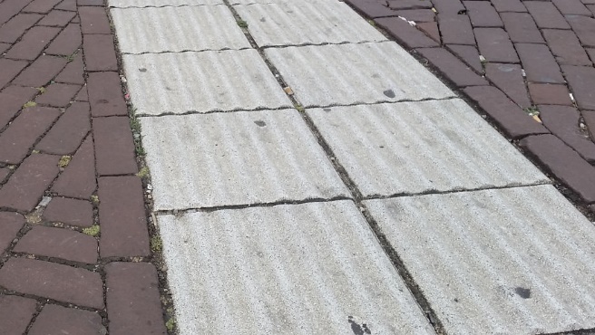
To illustrate the difficulties involved, Figure 2 provides images of six relevant British locations (each providing vehicle access to/from a smaller side street or entrance).
Example 1 is the only image showing a location judged by this study to provide an unambiguous continuation of the footway. For many of the other examples it was difficult to judge whether the footway continued, or whether the drivable space was part of the carriageway (or whether it was neither footway nor carriageway). Example 2 might traditionally be called a “side road entry treatment” because it does not appear designed to continue the footway. Example 3 has been called a continuous footway despite it being visually and physically less significant because of the lack of visual contrast and level access for vehicles. Example 4 is very like Example 1 but is not surfaced as a footway. Example 5 might traditionally be called a “footway crossover” because it provides access to private land. Example 6 might traditionally be called a “raised side road entry treatment”.
Image 1: Footway appears to continue in an unambiguous way. Drivable space at footway height. Steep access ramp.

Image 2: Drivable space at carriageway height, but significant contrast with carriageway surface and similarity to footway surface.

Image 3: Little carriageway-footway contrast. Drivable space at carriageway level. Interpreted as continuation of footway?

Image 4: Surface implies break in footway. Steep ramp significantly slows vehicles. Drivable space at footway height.

Image 5: Private entrance over footway. Frequent access by large vans. Footway drops to carriageway level.
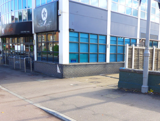
Image 6: Surface implies break in footway. Raised drivable space feels like a speed table.

The project recorded details of designs at 512 British locations.
Identifying whether or not designs were continuous footways proved very difficult, more so than we had expected.
Of the locations mapped we decided that:
40% (around 200) definitely fitted this study
24% (around 120) fitted this study to a significant extent (but not entirely)
17% were marginal in terms of characteristics
10% probably did not fit this study
9% definitely did not fit this study.
Our main learning was about how ill-defined continuous footway designs are on British streets. This measure was, as a consequence, inexact and subjective.
In many places we could see designs where there was some sense that the footway continued over the side road end, but the following were also true:
In many locations:
drivers might not really take much notice of what physically was an insignificant barrier to speed or progress
it was difficult to decide if the area to be driven on looked like footway, carriageway, or some kind of special area
small details made the difference as to whether the area that could be driven on looked like carriageway or footway – such details included the presence or absence of specific paint markings.
There were designs which:
we think were intended to continue the footway, but where the area driven on was of a very different colour and texture, making this area unlike the footway
were probably not intended to continue the footway, but where the area driven on was of a colour and texture much like the footway.
Walthamstow in London provides a very specific design that is being used across a wide area, with perhaps 100-200 examples, often with an associated cycle track. The literature review found indications8 that these were called Copenhagen crossings or “blended crossings” by the local authority (and that these were not seen to be continuous footways), but during the project these designs were referenced as continuous footways by participants on several occasions.
We did not find an equivalent situation anywhere else in Britain. We could see that the Walthamstow design tended to provide a larger area at the junction (not just covering the area that can be driven on), with a distinct surface, with a colour and texture different from both the surrounding carriageway and footway. The area that provides vehicle access is at the level of the surrounding carriageway. The judgement over whether this area continues the footway or provides an area that is neither footway nor carriageway, is a very subjective matter.
Figure 3 shows two images of these Walthamstow designs (although difficult to see in the image, the edge of the drivable space is defined by the lack of a kerb along the edge of the main road – an area also marked with the square white “elephants footprint” markings along the edge of the cycle track).
Image 1: Close up of showing drivable space

Image 2: The same area, photographed from further away

The use of designs that appear to continue the footway over the end of a side road are not all new, some appearing to have existed for decades. Given the absence of the term in older design literature, we doubt that these were referred to as continuous footways when built. In later work one of our key informants, with a long expertise in this area, suggested the same.
(Note that the project did not attempt to date infrastructure with any accuracy, so the observation above is an informal one, based on our experience of analysing street design and the apparent age of the infrastructure judged by its condition.)
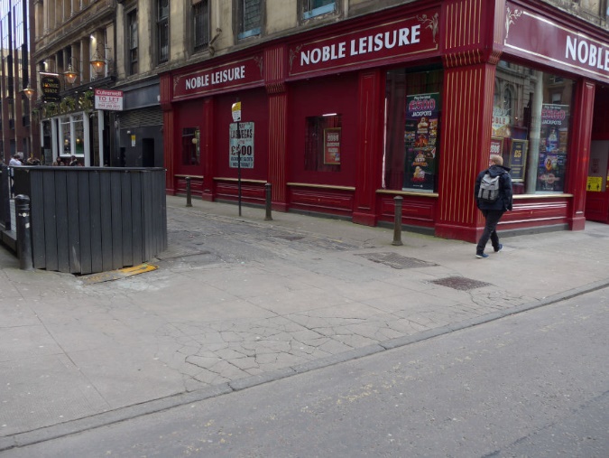
Figure 4 shows images of the entrance to Drury Street in Glasgow, one of our detailed-study sites, which appears to be an example of such a situation.
Image 1: From the perspective of a pedestrian
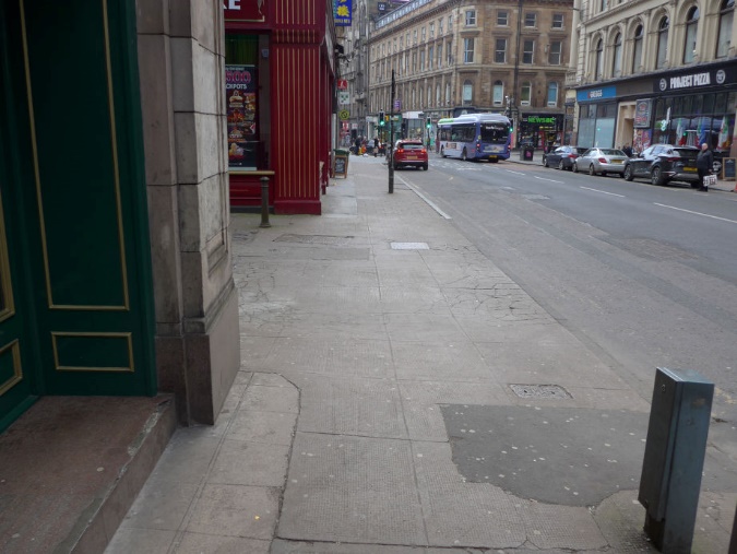
Image 2: From the perspective of a driver turning in
Entrances and exits from private land are not all provided by allowing vehicle access over a footway. Many are constructed as if with sections of carriageway, requiring pedestrians to step down a kerb, and up another. We could see little consistency, so that both busy and quiet entrances are designed as both footway crossovers9 and with a kerbed carriageway.
In Britain, many (probably most) footway crossovers are constructed to have a footway that all slopes toward the carriageway. This slope is often called “crossfall” in technical literature. Figure 22 in Section 8 provides images of footway crossovers.
In contrast, it proved simple to classify Dutch junctions and entrances as either having or lacking an “exit construction” (“uitritconstructie”). It was also easy to anticipate where these would be found – confirming that the approach to their use was consistent across the country.
Our literature review demonstrated that Dutch exit constructions are also applied at private entrances. We were surprised that it was difficult to find examples of the kinds of private entrance to driveways of private houses that are common in Britain. We could see that these do exist, but there appear to be few housing estates where they are common.
One key feature making Dutch exit constructions recognisable is the use of a specific ramped kerb (see images in Figure 23, page 86, and more details in Appendix 2). Our review of Dutch literature confirmed that the presence or absence of these “entrance kerbs” (“inritbanden”) is taken as a key indication of the presence and status of an exit (which in the practical sense also means an entrance).
In Britain we recorded only a very small number of junctions or private entrances where kerbs similar to Dutch entrance kerbs have been used. Ten to twenty were recorded in Glasgow, all on small lanes or entrances. (Appendix 2 provides a discussion of ramps and the recent use of kerbs supplied by the company Charcon, which are inspired by Dutch entrance kerbs.)
The project conducted a few investigations of the use of relevant designs elsewhere in Europe – mapping locations in Berlin, Brussels, Copenhagen, Dublin and Stockholm. Examples were relatively rare, and some of those found provided only an ambiguous sense that the footway continued.
What we saw in the centre of Barcelona was of particular interest. Within denser areas many smaller lanes or private entrances/exits are designed in a way that is recognisably like Dutch exit constructions. This similarity arose, in particular, from the use of ramped kerbs very much like Dutch entrance kerbs.
In this section we describe our approach to our work with professional informants – people employed in relevant professional roles. This covers two groups, namely design-orientated informants and user-orientated organisational representatives. It sets out who we spoke to, how we did this, and what observations we derive from this work.
Rather than attempting to consult with a large number of organisations representing disabled people and other interest groups, we chose to work more intensively, and in-depth, with a smaller number of key organisations, judging that:
The extensive literature review meant that the project had already established the views of many key informed/involved organisations
It was more important to focus on a smaller number of organisations established as having a position on this infrastructure, and to seek a deeper understanding of their knowledge and views
The project would also work directly with individual disabled members of the public to understand the range of experiences that they encountered (see Section 6).
This part of the research took place mostly after completing the literature review and mapping/GIS work. It was ongoing throughout the remainder of the project.
The title design-orientated informants was used to mean people who were involved either in designing or supporting the provision of continuous footways, or who had professional knowledge about them. We spoke to these people primarily for their professional expertise. The title user-orientated organisational representatives was used to mean people with a relevant professional or voluntary role with an organisation, whom we could ask about the views of their organisation. Together we describe these groups as “professional informants”, distinguishing these from the individual members of the public we worked with separately.
For simplicity we describe this work as if those involved can be divided easily into these categories. Most design-orientated informants worked for organisations involved in the design or provision of infrastructure. Most organisational representatives worked for bodies organised to support or represent disabled people – however these groups are interconnected. Some of those we worked with were interviewed both for their personal design-related expertise and to understand the position taken by their organisation. People representing their organisations often contributed a wider personal and professional expertise.
A number of the people we worked with have lived experience of disability, and personal experiences were offered as evidence for the project. We report on our learning from such input in Section 6, alongside learning from focus groups and site visits with disabled members of the public.
It should be noted that while this report is focused purely on our work on continuous footways, this was carried out alongside research into the provision of cycle tracks at bus stops. Most of our work with interviewees was simultaneous on both of these themes.
The research work comprised both semi-structured interviews and more informal or ongoing contact. The latter was an important element of our work and helped us to understand what we were learning, and to test out ideas and conclusions. Even where semi-structured interviews were used, these – by design – were followed up with unstructured, informal discussion.
This work included ongoing contact, throughout the research project, with a project Reference Group in which we brought together people with a wide range of professional knowledge and a range of differing views, including on design, engineering, inclusion, disability, academic research, the needs of pedestrians and infrastructure for supporting cycling.
We name Reference Group members inside the front cover of this report.
Work with design-orientated informants included semi-structured interviews with:
Four local authority officers managing the installation of relevant new infrastructure in different cities
An engineering consultant involved in supporting local authorities to install relevant new infrastructure.
We also had discussions with:
A team in Manchester involved in researching the impact of relevant new infrastructure
Consultants from five organisations with specialist knowledge about relevant new infrastructure
A local authority team responsible for a specific project involving the installation of relevant infrastructure in Edinburgh (and for running research into its effects)
Researchers and others looking at the effects of similar infrastructure in other countries
Two local authority officers responsible for the installation of relevant new infrastructure in Leeds.
Work with user-orientated organisational representatives included semi-structured interviews with:
Representatives of three national organisations campaigning for improved conditions for blind and partially sighted people
A representative of a national organisation concerned with cycling for disabled people
A senior representative of a national organisation campaigning for changes to infrastructure to support cycling
A senior representative of a national organisation involved in promoting, designing, and funding changes in infrastructure to support cycling and walking.
Work not fitting the above categories included:
Discussions with two staff employed to teach the use of long-canes or guide dogs (one a long-cane user), and with them a visit to several relevant Scottish junctions (including two of our detailed-study sites)
Wider discussions (mostly focused on problems crossing cycle tracks) with people involved in providing or coordinating training on the use of long canes or guide dogs, and with a representative of a relevant professional network organisation.
Staff from the organisation Transport for All attended the semi-structured interviews and some of the other discussions. The semi-structured interviews were recorded, and Transport for All helped to analyse these for the key points and themes that had been raised.
Contributors were assured that their input would be strictly confidential, that quotations provided in the report would be anonymous, and that any recordings or transcripts would be deleted at the end of the project. We did this because:
It was vital that contributors could be honest and open
We wanted contributors to feel able to be clear about the limitations of their knowledge
Where contributors were not involved officially as a representative of their employer, we wanted them to be able to speak freely about internal challenges within their organisation
Where contributors were involved as representatives of their organisations, we wanted also to hear their personal views
This was not an open consultation to establish what positions were held, but rather an exercise to deepen our understanding of positions already established in the literature review work.
Before approaching organisations involved in campaigning for inclusive streets (where we arranged interviews with their representatives) we had already used the literature review to establish a set of key concerns shared by many of these organisations, and by people they represented. Rather than carrying out another survey of the views of these organisations (and others like them) we chose instead to work with a small number of these organisations, extending our understanding beyond these established positions.
We reassured the organisational representatives that we already understood:
The importance of kerbs for blind and partially sighted people in defining the edges of a footway
The importance of tactile paving for marking kerb-free transitions between footway and other areas
Problems with large areas of tactile paving
The importance of consistency in the use of tactile paving.
Below we report observations drawn mostly from interviews with people employed in roles in changing infrastructure (rather than interviews with representatives of user-orientated organisations). These were people employed as designers, engineers, local authority officers, or in similar roles. For the sake of simplicity we are also including learning from interviews with representatives of organisations focused on better cycling infrastructure, even where the organisation was more user-focused than design-focused.
None of these informants could point to any widely agreed definition of continuous footways – although there was agreement that they were designed to continue a footway over a side road.
Most spoke, in one way or another, about continuous footways being a way to increase the priority of pedestrians over vehicles entering or exiting a side road. Some provided additional detail. For example, one said that the objective was that pedestrians “don’t even have to look up”. Another said, “I think a continuous footway is where the footway dominates, ultimately the cars feel they have to give priority”.
Some commented on continuous footways providing a kerb-free route, useful to those using wheelchairs or mobility aids.
Some agreed with us when we suggested that continuous footways may often be installed as part of work on cycling, but others disagreed.
Several design-orientated informants commented that continuous footways are being introduced as part of bigger changes to encourage people to walk or cycle, and to discourage them from driving. We asked one senior participant about whether changes to support cycling were putting a lifestyle choice (to cycle) above inclusion. This person disagreed, suggesting that the need to encourage cycling was urgent, not as a lifestyle choice but something necessary because of “the climate emergency”.
One or two participants made a comparison between continuous footways and footway crossovers. One said that before the term continuous footway had become popular they would have called these “driveway crossings”.
Some participants confirmed that continuous footways are being built as part of schemes to support cycling, but some argued that their use wasn’t normally connected to these.
We briefly asked for comments about what makes a continuous footway work well. The following were suggested:
The area to be driven on should look like the rest of the footway, even if constructed using load bearing materials (such as smaller block paving)
The area of footway that can be driven over should be accessed by ramps (with ramp steepness a factor in slowing vehicles, although this might be limited by the need not to damage vehicles)
These access ramps should create a visually straight kerb line along the edge of the main road, rather than there being any visible corners
There is a need to limit the swept path that can be taken by vehicles, ensuring they have to make a tight turn (at slower speed) when entering the side road
There is a problem creating a visually obvious continuation of a footway in those circumstances where there is little existing visual contrast between asphalt footways and asphalt carriageway
There is a link between the use of continuous footways and new rules in the Highway Code (Rules 170, 206 and H2)10.
These suggestions are in line with those detailed in previous research, and particularly in the study by UWE11, as also summarised in the literature review summary section of this report (Section 3).
Some senior and influential participants were aware of the challenges that continuous footways might create for blind and partially sighted people. One reflected that blind and partially sighted people might “be completely at the mercy of the turning vehicle adhering to the rules”. However even those participants who were aware of this problem were unsure of how to solve it.
In contrast, one senior representative of an organisation involved in support for cycling-related infrastructure, when asked whether continuous footways might not be accessible for everyone (i.e. inclusive), responded, “Is that a problem? It had never occurred to me that that might be a problem”.
We concluded that knowledge about the possible effects of continuous footways on the inclusiveness of streets is variable and limited amongst some groups.
We discussed the use of tactile paving in some depth with a number of participants and confirmed that design guidance is inconsistent.
Some suggested that tactile paving should not be needed at continuous footways if these are working properly. Others suggested that the problem with providing tactile paving was that it might change the behaviour of pedestrians, making them less likely to walk confidently. One person, who had been involved in changing many junctions, specifically stated that anything that encourages a pedestrian to look up to negotiate passage is unhelpful when they should be claiming their right of way.
Other participants suggested that the problem with tactile paving is that it visually marks the edges of what then looks more like a section of carriageway, thus weakening how the continuous footway is perceived by drivers.
More than one participant spoke about the challenges that blind and partially sighted people face more generally, pointing out that the absence of tactile paving might create problems with overall navigation for those who want to know they have reached a side road. One spoke about how too much tactile paving can become confusing.
Many participants were aware that there is an ongoing debate about how tactile paving ought to be used at continuous footways, and a need to research options.
The designers we approached considered that they are working from experience as much as guidance, and indicated that we had not missed any key guidance in our literature review.
We confirmed our finding, based on the review, that there is a problem with the inconsistency of different guidance. One participant spoke about the lack of clear rules to follow, and about having to have their own “belief system” to guide their work. We took this to mean that designers who want to make significant improvements to how streets function for pedestrians are not supported by any national plan, philosophy or agreed design principles to that effect.
We were told by more than one participant that they faced big challenges in dealing with others within their organisation or authority, and that these held them back from doing better work.
One (from an engineering consultancy) highlighted differences in approach between, on the one hand, those involved in more innovative projects and, on the other hand, “highway engineers”. They explained that the company’s highway engineers were often driven by concerns about “avoiding liability”. This participant suggested that documents like “DMRB” (Design Manual for Roads and Bridges) were seen as “bibles” by the highway engineers. They contrasted this with the apparent lower status of other documents like “Designing Streets” or “Manual for Streets” which were intended, when written, to supplant the use of these for the design in more urban environments12.
Another participant spoke about those involved in “road safety audits” referencing the “Traffic Signs Manual” as another equivalently influential document. We were told that these people “want things to be legally correct” and that they had been told internally “it’s not you that’s going to end up in court”.
One participant spoke about the value of narrowing the space that can be driven on at a continuous footway so as to produce a “give and go” situation – where only one vehicle can pass through the space at a time. They then described a situation where that approach had been rejected because of fears that traffic on the main road would be held up if trying to enter the side road. The street in question was a short cul-de-sac; the “main” road had a speed limit of only 20mph; and in mapping work we had classified the structure provided at the side road end as not providing a continuous footway.
To understand the relationship between ramp steepness and detectability we carried out a site visit with two mobility trainers who work with blind and partially sighted people. One was a long-cane user.
We visited junctions on Sauchiehall Lane (with Holland Street), Scott Street and Pitt Street (with Sauchiehall Street) in Glasgow – two of our detailed-study sites – and a third site similar to that at Sauchiehall Lane site.
Together we checked, informally, whether we felt that a blind or partially sighted pedestrian on the footway would be able to detect the unusually steep ramp defining edge of the continuous footway at Sauchiehall Lane (i.e. between the continued section of footway and the main carriageway).
More detailed experiments are needed to provide better evidence, but we concluded that this ramp was probably detectable – either with a long cane or underfoot. We speculated that most guide dogs would consider this to be the footway edge, although proper evidence is also required to confirm this. It was evident that such a ramp is significantly easier to detect than the edges of the drivable space at our other detailed-study sites (which were flush or with more gentle/low ramps).
Below we report observations drawn from interviews with representatives of user-orientated organisations. Also included, for simplicity, is learning from work with those employed in wider roles by such organisations – although we met with this latter group to learn from their individual professional expertise, rather than to discuss the positions of their organisations.
These interviews confirmed that there has been confusion over exactly what infrastructure is covered by the phrase continuous footway. In general, the organisational representatives had specific locations in mind but little or no knowledge of the many different designs used throughout Britain.
None of these organisational representatives made comparisons between the concepts of a continuous footway, footway crossover, and side road entry treatment, but many expressed confusion over the reasons why specific designs were being used.
Comparisons were often made in these interviews with the idea of “shared space13”, with many of those we spoke to thinking that the intention of designers was to create ambiguous areas – where pedestrians and drivers negotiate passage with one another. This was an important observation because of the contrast with what we heard from designers, who instead spoke about providing pedestrians with priority. Similarly, in our literature review we had established that the limited guidance available focuses on providing pedestrian priority.
When discussing questions of safety from traffic, all those user-orientated organisational representatives interviewed considered that continuous footways created situations where pedestrians needed to stay alert, choosing a safe time to cross the side road by observing traffic, or negotiating visually with drivers.
None of the people interviewed as representatives of organisations focused on disability spoke about continuous footways being deployed as part of more long-term and comprehensive efforts to refocus streets on the needs of pedestrians. This contrasted strongly with responses from those involved in designing and providing continuous footways.
The strongest sense was that people felt changes were ill-thought-through, that these were happening without good reason or because of the incompetence or even obsessions of designers. In some cases, there was a feeling that changes were all being made because of an unreasonable focus on the needs of cyclists, putting these above the needs of others.
Organisational representatives tended to speak about improving streets with the removal of some recent changes, the restoration of kerbs, the addition of dropped kerbs, improvements to maintenance, and the addition of new signalised crossings (i.e. with traffic lights/signals). We heard less about any vision of more profound change.
This contrasted to the way that design-oriented informants involved in the project expressed enthusiasm about more profound change in favour of pedestrians and cycling.
These and other differences in views are summarised in Section 5.5 below.
We heard a great deal of detail about the importance of kerbs, as a key feature helping blind and partially sighted pedestrians to know where the edges of a footway are. One participant put this simply and very clearly, saying: “Kerbs are really, really important”.
Several interviewees were keen to point out that guide dog users – not the guide dog – judge when it is safe to cross the carriageway of a road. As an additional detail, it was confirmed that some experienced guide dogs may act of their own initiative to avoid injury to themselves or to their owners, thus providing some additional reassurance as to whether a carriageway was safe to cross.
It was indicated that some blind and partially sighted people may choose to cross the end of a side road by walking a few metres into the side road, seeking a place where kerbs are at right angles to the direction of crossing, away from the junction mouth and usual desire line. The word “indenting” was sometimes used to cover this practice. We also discussed the practice of walking much further into the side road to cross it well away from the junction.
Some participants spoke about the difficulties that blind and partially sighted people can have when trying to walk in a straight line across a more open area – meaning one not bounded by kerbs, walls, fences or similar structures. With this in mind, one participant highlighted the value of features that can provide a “guide line”, by which we mean something that can be followed easily, with a long-cane or by feeling for it underfoot. Another participant spoke about following guide-line features within a railway station in the Netherlands. (We found it helpful that one of our researchers had also followed such guide-line features along Dutch streets using a long-cane – under the guidance of an experienced long-cane user.)
Figure 5 (overleaf) shows guide-line paving used in a Dutch station and on a Dutch street.
Image 1: Guide line paving in a station
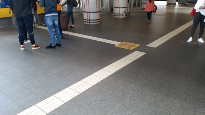
Image 2: Second close up image of paving in a station

Image 3: Guide line paving on a street

Image 4: Close up image of the paving on the street
Several participants spoke about mobility training being difficult to access. One explained that the availability of mobility training in one area had had an effect on where they chose to live when they knew they were losing their sight. This participant emphasised how long some other blind and partially sighted people had to wait for training.
Representatives of one organisation did not agree to take part in a structured interview but asked to have a discussion during a site visit in Glasgow. Overall, it was clear they were strongly opposed to the concept of continuous footways.
One of their representatives expressed the view that Dutch continuous footways (i.e. exit constructions) do not work well at all, and that they had observed “chaos” at one relevant Dutch junction.
This organisation highlighted particular concerns about the effects of the design at junctions on Sauchiehall Street, one of which was a detailed-study site. Based on our study of this site we agreed with many of their observations about how these junctions worked, and the problems that might result for blind and partially sighted people. However, we had judged that the designs at these junctions provide an ambiguous area rather than an unambiguous continuation of the footway, and we had recorded that the lack of physical features constraining vehicle speeds and paths was a problem.
The same organisation was invited to visit the nearby detailed study-site at Sauchiehall Lane with us as we had observed different conditions and behaviours there, however they declined. With other organisations we discussed what could be learned by studying locations where we’d observed problems but also those where we saw few or no problems.
Table 1 below provides an impression of some of the differences that were apparent in the views expressed by the design-orientated and user-orientated interviewees. The contents of this table are greatly simplified and generalised for clarity (meaning that the comments do not provide a specific indication of the attitudes and ideas expressed by any one person or during any single conversation).
It should be noted that in highlighting differences in views we do not intend to imply that one or other party was correct and the other wrong. Evidence from other parts of this study may be seen to support one or other position. For example, at many of the sites we studied conditions on the ground were closer to those described by user-oriented organisational representatives than they were to the ideal described by the design-orientated informants. It might be concluded that it is the role of user-oriented organisations to represent not theory but the real-life experiences of their members. Similarly, any failure to outline a bigger vision for change might result from a lack of evidence, on the ground, that bigger changes are likely.
In the report discussion section (Section 8.4) we discuss this issue further, putting the onus on those responsible for pursuing changes to streets to work in depth with disabled people and organisations representing them, We conclude that it is in the interests of all that learning takes place in both directions.
In this web page version of the report Table 1 has been converted into two lists to aid accessibility.
This first list (to compare to the second list) is of beliefs expressed by design-orientated informants
Difficulties with designs arise because of the resistance which exists to reducing the level of priority given to vehicles.
The overall objective of changes like these is to prioritise pedestrians over vehicle movement.
The aim of a continuous footway is to create a situation where pedestrians have unambiguous priority over vehicle movement (no mention of the idea of “shared space”).
Continuous footways are one element in a much bigger set of changes (beyond maintenance, dropped kerbs, etc) which are required to make streets more inclusive to support both pedestrians and cycling.
Cycling will only become something which is ordinary with changes to infrastructure. Current conditions mean that sometimes people who are cycling behave badly (e.g., cycling on pavements). There are individual people prepared to behave badly and who cycle.
The need for more cycling and for this to be given a higher priority is established in policy and evidence.
The second list (to compare to the first list) is of contrasting beliefs expressed by user-focused organisational representatives
Difficulties with designs arise because of the incompetence of designers, or because they are focused on prioritising cycling (even at the expense of inclusion).
The overall objective of changes like these are unclear, or are to prioritise cycling over other modes of transport.
The aim of a continuous footway is to create an ambiguous situation where pedestrians need to negotiate with drivers to progress (linked explicitly to the idea of “shared space”).
The changes that are needed to make streets inclusive include the addition of crossings and dropped kerbs, and the maintenance of existing streets. The bigger changes that have taken place are to support cycling and they generally make streets less inclusive.
Cycling is a problem because many or most cyclists behave badly (pointing to specific observations such as of cyclists ignoring red traffic signals).
The need for more cycling is unproven and contested.
This section reports on our work with disabled pedestrians (in contrast with the previous section that describes our work with design-orientated informants and with organisations representing disabled people). The objective of this thread of the research was to ensure that we heard first-hand about the variety of experiences that different disabled people face.
It should be noted that the broader research project also looked at problems with bus stops where there is a cycle track, and much of the activity listed below was undertaken in a way that investigated experiences related to both types of infrastructure. This work was focused on experiences as a pedestrian – we did not try to investigate the experiences people had when driving.
Transport for All (TfA) organised and ran four online focus groups and four site visits (each examining both bus stops and continuous footways). Researchers from Living Streets were closely involved in all activity throughout the process.
The partnership enabled:
The focus groups and site visits to be arranged by a user-led organisation with expertise in ensuring an inclusive “pan-disability” approach
Focus groups to be facilitated by a disabled facilitator, appointed by TfA
The concerns of the disabled people participating to be properly heard, and for them to have confidence that they were being treated equitably.
TfA sought contact with people who might be interested in being involved, and selected only some of those replying – seeking to ensure that participants had a range of impairments and ages.
Twenty participants were involved in total, although not all took part in both focus groups and site visits.14 Five participants had a visual impairment (sometimes alongside other impairments).
Two TfA staff attended the London site visits, and a third TfA employee attended the Glasgow site visits. Each of these was themselves a disabled person, one using a wheelchair during the visits.
TfA worked with us to assess the risks involved in organising site visits to look at continuous footways and bus stops. A number of our study sites did not provide the conditions they felt necessary to ensure participants were comfortable and felt safe. TfA also had concerns about managing risks to participants, and about making them comfortable, on busy streets more generally. The sites we did visit with disabled people were not problem-free in this regard. Even here we judged that it would have been irresponsible to suggest to some blind or partially sighted participants that they cross some of the spaces on the streets without support. This underlined the importance of gaining a first-hand perspective.
Sites were chosen (i) to provide a good understanding of what might be more effective designs, and what might be less-effective, and (ii) to be close to available accessible meeting space, enabling more focused conversation as part of the event.
The events were as follows:
Online focus group, London-based participants (continuous footways)
Online focus group, London-based participants (bus stops)
Online focus group, Glasgow-based participants (continuous footways)
Online focus group, London-based participants (bus stops)
Site visit, London, bus stops (and continuous footways)
Site visit, London, continuous footways (and bus stops)
Site visit, Glasgow (bus stops)
Site visit, Glasgow (continuous footways).
Following the work with disabled members of the public, TfA organised a “solutions workshop”. This was attended by the key Living Streets researchers, four TfA staff (two being access consultants) and a representative of the Mobility and Access Committee for Scotland. This was facilitated by a TfA staff member who had not previously been involved in the project.
During the workshop, improvements to continuous footways that had been suggested by members of the public were analysed for their advantages, disadvantages, practicality, and value.
Outside of the structured work organised in partnership with TfA, the project’s contact with disabled people also included:
Discussions with a group of disabled people working on the accessibility of public transport.
Detailed discussions about the personal experiences of a (further) guide dog user, and about the specific techniques that person uses when navigating British streets.
The participants were given the opportunity to suggest solutions which might make the sites we studied with them more inclusive.
Suggestions included:
The use of steep ramps to slow vehicles
Signage to instruct pedestrians to look for traffic
The addition of zebra crossing markings
The reversal of changes that make the footway appear visually continuous (and the use of various high-contrast effects to emphasise the presence of the drivable space)
The addition of tactile paving to mark the edges of the drivable space
Road markings to ask drivers to slow down
The use of traffic signals
Work to improve drivers’ awareness of the Highway Code
Mirrors used in places where visibility is restricted.
The following underlying ideas were discussed in connection with the wider use of streets by disabled pedestrians. Some of what was learned from this work was unsurprising – corresponding to what we had understood from previous studies, or what we would expect from any conversation with members of the public. We have called these underlying ideas because they are well understood, not because they are unimportant. They are listed because – although they are well known – many participants had no confidence that anyone was designing according to these principles.
Some of the ideas relate primarily (although not exclusively) to the inclusion of blind and partially sighted pedestrians. These included:
The particular importance of consistency in infrastructure features (providing predictability and increasing confidence)
The difficulties that arise in dealing with vehicles or people using devices which are harder to hear, such as electric vehicles, e-scooters, and bicycles, particularly when other traffic noise covers what noise these do make
The importance of kerbs:
The importance of visual contrast:
The importance of signalised crossings (i.e. using traffic lights), not only for blind and partially sighted people, but also for those who need more time to cross, and / or are less able to predict more complex movements of vehicles
The importance of tactile paving – used correctly and installed consistently – advising the presence of controlled crossing points (with a zebra crossing or traffic signals) and warning of locations with a kerb-free transition between footway and spaces where vehicles might be encountered.
Issues around kerbs were broken down as follows:
The importance of kerbs and other distinct boundaries in defining a clear path that can be followed, which is known to be separate from vehicles (including bicycles)
The importance of kerbs as being a consistent, defining feature marking the transitions to and from footway space when pedestrians are crossing carriageway space or cycle tracks.
Issues around visual contrast were broken down as follows:
The importance of visual contrast (in both colour and tone) making the difference obvious between areas of footway and areas where vehicles, including bicycles, might be encountered – specifically for partially sighted people, but also for others who might need this transition to be more obvious
The importance of visual contrast being present in wet weather or after dark (often not the case in practice)
Some ideas related to wider groups of pedestrians. These included:
Many people, including those using wheelchairs and some other mobility aids, can be hidden behind most vehicles, even small cars
People do not trust those driving (or cycling) to behave in line with established rules, and consequently rules don’t reliably ensure safety
Poor surface quality makes some journeys impossible or extremely difficult for many people, including those with impairments to their walking or balance or who are wheelchair users
The value of kerb-free routes for people using wheelchairs and other mobility aids (a potential conflict with some above points)
A lack of dropped kerbs, or other level access, makes some journeys impossible or extremely difficult for wheelchair users
The low quality of some dropped kerb arrangements is problematic, particularly where slopes are steeper, slopes are not in the direction of travel, and where surfaces are not sufficiently flush.
We found that the idea of a continuous footway is not well understood by members of the public. Many of those we spoke to were able to draw learning from other situations, and others related their experiences at different types of entrance, such as at car parks (which might be called footway crossovers).
In discussions around the priority given to pedestrians or motor vehicles in the Highway Code many participants were unsure about which road users have official priority in a range of particular situations. Also, their expectations were that those driving and cycling will, in any case, take little notice of many rules about priority. One person spoke about “people needing to rely on the mindset of a driver on any particular day” and that no matter what the rules say it would always be seen “as the pedestrian’s fault” if they were injured.
Some participants felt that changes introducing new infrastructure were often being put in place to favour limited groups of road users, and particularly to favour those who cycle. They saw that the needs of cyclists were being prioritised, with little regard to the disadvantages arising for a wide range of disabled people. For example, one person suggested that a local authority was trying to create a “cycle-only borough”.
However other participants pointed out that they would not cycle in their city because of the traffic conditions.
Importantly, some people highlighted how the general conditions on British streets can disadvantage or even exclude people:
One participant spoke about using buses to travel very short distances because of local accessibility issues: “sometimes I just take a bus to cross that bit”
One blind participant referred to changes in infrastructure meaning that in places where they had previously felt secure, “it’s like a guessing game”
One participant commented that when moving more slowly, “being able to jump out of the way [e.g. to avoid an oncoming bicycle] is a problem”
Another participant, asked about problems with parked vehicles blocking the footway, described sometimes having to go home and repeat the journey later in the day hoping the pavement would be clear.
As in interviews with organisational representatives, we discussed crossing techniques with several blind and partially sighted participants.
Asked about how parked vehicles affect crossing the end of a side road, one participant contrasted the way in which their guide dog would “bounce” across the road when a view was clear, while only edging forwards if parked vehicles blocked the dog’s view of oncoming vehicles. The same person spoke about reaching out to touch parked vehicles to confirm their presence or to judge where it might be safe to stand in preparing to cross.
Interviewees talked about the problems caused if there are large numbers of parked vehicles along the edges of the carriageway of the side road. One guide dog user explained that it was sometimes impossible to pass between parked vehicles to get onto the carriageway at all. He also described having crossed in a chosen location, only to be faced with parked vehicles preventing access to the far footway (as illustrated in Figure 6). He said he sometimes had to walk back along the actual carriageway to the junction just to get onto this footway.

Blind and partially sighted participants highlighted the problems involved in navigating even ordinary streets. Although many of these problems are well known, what was striking was how consistently we were told of the high level of concentration required, and the challenges inherently involved.
Key points were:
Participants described how counting features to track progress on a journey – while also staying safe – is difficult
One participant spoke powerfully about his fears about becoming completely lost, having taken a wrong turn, even on very familiar journeys. We were reminded that few other pedestrians (without a visual impairment) face such challenges
This participant also spoke strongly about how navigation can be easier when there is consistent noise from traffic on a busy road, and that quieter environments are more alarming because there was less noise to orientate by, and more of a sense that they had become lost
Several participants spoke about their real fear that they would be injured by other people (as opposed to vehicles), for example by those cycling or using e-scooters on a footway, or that their guide dog would be hurt or their long cane damaged
Some participants pointed out numerous places where it was easy to walk onto a cycle track or carriageway without knowing they had done so
Partially sighted participants spoke about the additional problems of navigating after dark, due to the decreased visual contrast between key areas, or the loss of more visually obvious features, like a brightly coloured building.
Participants spoke about environments becoming more difficult to navigate when they are more crowded, increasing the risk of a collision with another pedestrian or of a long cane user hitting the feet of another pedestrian. We were told this caused people embarrassment, and some mentioned being wary of the risk of the other pedestrian responding with anger.
According to participants it can be much easier for some partially sighted people to judge risks when the vehicles or bicycles they wish to avoid are arriving from one direction only; and they sometimes face a situation where they cannot see that a driver is trying to communicate by waving through their windscreen.
Some participants spoke about the way in which tactile paving can help blind and partially sighted people to navigate, but we also discussed its limitations and how it can confuse people when over-used.
We confirmed that tactile paving is often used only to provide a warning of a kerb-free transition between footway and carriageway, and when used in this way it does not necessarily indicate an optimum (or even safe) crossing point.
Several participants explained how, at (standard) junctions with swept kerb corners, they would “indent” into the side road (away from any tactile paving) to a place where kerbs at either side of the carriageway were more parallel to one another. These kerbs then acted as a means of lining up to cross, reducing the risk of deviation from the desired direction.
Figure 7 illustrates standard blister-style tactile paving and shows an example of it used at a place where crossing might be hazardous.
Image 1: Showing a guide dog user standing at a dropped kerb which slopes mostly towards the main road, not in the direction they might want to cross the side road (Image copyright © @Heardinlondon)

Image 2: Showing tactile paving at a dropped kerb at a very wide side road entrance, with vehicles driving in and out of the side road
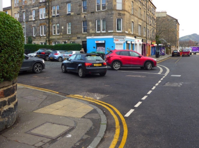
It was demonstrated to us that tactile paving at a dropped kerb or controlled crossing is made easier to understand by an associated slope toward the carriageway. This slope gives a sense of direction, making it obvious that to one side is carriageway and to the other is footway.
We confirmed that it is understood that many blind and partially sighted pedestrians struggle to feel the orientation of the blisters on blister-style tactile paving in a way that allows them to orientate themselves (to choose the ideal angle to face for crossing the road). There is also a problem that the slope on dropped kerbs does not typically point in the desired direction of travel (see Figure 7).
The problems with such dropped kerbs include that they can:
Suggest, to blind and partially sighted pedestrians, a crossing direction that would actually take them out into the main carriageway
Create risks that wheeled mobility aids, like mobility scooters, tip over (because of being navigated at an angle to the slope).
Participants highlighted the fact that larger level areas of tactile paving are harder to interpret, and that multiple neighbouring areas of tactile paving can produce a confusing situation.
Participants commented that some tactile paving changes its meaning according to its orientation. For example, where “ladder and tramline” arrangements are used to indicate an area intended for cycling – a situation in which the direction of the ridges (along or across the pedestrian’s path) has significance. At some sites we could see that such paving had been used in places where it could be encountered by pedestrians arriving from different directions, making its meaning very difficult to interpret as a result.
We discussed whether alternative tactile paving layouts might be useful in situations where a continuous footway could be proven to unambiguously prioritise pedestrians.
Figure 8 illustrates two sites where alternative arrangements have been used. In both cases the paving is set back from the area where vehicles might be encountered, and in one the paving used is corduroy-style rather than blister-style.
Image 1: showing corduroy paving placed far from the drivable space

Image 2: showing standard blister style paving located before reaching the side road

Participants were concerned about any new arrangements being more confusing and complex than existing standardised approaches. They highlighted that the latter mark the obvious transition between footway and carriageway in a way that is relatively easy to interpret.
Through this discussion we became aware of particular problems that might arise, for pedestrians exiting the side road, if alternative layouts of tactile paving are used.
Pedestrians exiting a standard side road – assuming they are on the desired side of the side road – walk to the end of the side road then turn away from it on the footway beside the carriageway of the main road. While initially on the side road footway their path is bordered by the kerb of the side road. Forward movement is checked when they encounter the kerb of the main road (ahead). The presence of these kerbs simplifies navigation. If navigating a continuous footway, or other arrangement when the surface of the side road is raised to footway height, the detectable kerb to the side of their path is lost before they reach the carriageway of the main road, complicating navigation. Combined with this, any encounters with non-standard tactile paving arrangements may add further confusion.
Inclusive street design must accommodate people who have multiple impairments. One of the biggest challenges raised with us, in relation to continuous footways and other junctions, was about their accessibility to partially sighted people who rely on colour contrast, not on tactile paving.
A good example was one participant who is both partially sighted and a wheelchair user. She spoke about how she cannot see where the edge of many normal footways is when travelling along them. She said “I have to hug the building line” (to stay safe and to avoid falling off the footway).
Many people who are blind or partially sighted find it challenging to walk in a straight line over a more open area. The challenge grows greater:
If there are no clear features to allow a pedestrian to be certain about the direction they are setting off in
If there are no clear features to indicate when the pedestrian has reached the other side of the wider area
The larger the area is in which there are no features to navigate by
The more there are other threats and pressures (such as from traffic or a crowd of people) to deal with at the same time.
These factors are potentially problematic for the navigation of continuous footways.
One participant spoke about their experiences with parked vehicles at a footway crossover that had been created to provide access to a car park. She highlighted this because the crossover had removed the clarity of what is footway (and the associated kerbs), so people had begun parking on areas intended to be footway – blocking her use of these.
A significant number of participants described the problems tactile paving cause them because of difficulties with balance or pain as they walk across them. On journeys to and from one site we observed that a participant steered his wheelchair over mid-height kerbs rather than using dropped kerbs that had blister-style tactile paving before them.
Although conversations like this were focused on problems, some of the feedback on new infrastructure was much more positive. One participant spoke about the beneficial effects for wheelchair users when kerbs are removed. Using Sauchiehall Street in Glasgow as an example she explained “I use a wheelchair full time. When I was crossing to get to the restaurant I thought “wow, this is great” because I felt so safe.” Notably this street was criticised by participants with visual impairments.
Ten junctions were chosen for much more detailed study, referred to throughout this report as detailed-study sites.
At these locations we measured dimensions, took standard sets of photographs, recorded behaviours on short and long segments of video, and made structured and unstructured observations of behaviour. This was followed up by the use of fixed-cameras, mounted at height on masts, recording several days of footage of behaviours – which we analysed in detail later.
At all but one of these locations we judged that designers had attempted to prioritise pedestrian movement by continuing the footway of a main15 road over the end of a smaller side road.
At the tenth site (Simpson Loan, Edinburgh) we concluded that the designer had intended to create a side road entry treatment to try to indicate that pedestrians should be given some priority, without trying to provide a continuation of the footway across the side road. This site was chosen for study as a more standard junction, and to see whether the unusual configuration of the footway here affected user behaviours.
Full details about each detailed-study site can be found in Appendix 2. This section summarises our approach and the key evidence gained.
The detailed-study sites were chosen from those mapped earlier in the research.
To aid the research and offer comparison we chose sites:
In Scotland, England and Wales
Which provided examples where the side road carried either two-way traffic, one-way entering traffic, or one-way exiting traffic
With both very little use by vehicles and a much greater level of use
With both a complex environment and a simpler environment
With steep vehicle access ramps, gentle ramps, and a lack of any ramp
With changes that created tight corners for those driving, and without tight corners
Which convincingly created the appearance that the footway continues
Which failed to convincingly create the appearance that the footway continues.
The phrases “complex environment” and “simple environment” refer mostly to the level of pedestrian use, but also to how pedestrians behave. In this sense complex environments include those where people might be in groups, walking in and out of shops, or where people are walking in many different directions. In contrast, simple environments include those where pedestrians tend walk alone, along a predictable set of routes.
Our chosen detailed-study sites were as shown in Table 2. Full details, including illustrations, plans and photographs can be found in Appendix 2:
In this web page version of the report Table 2 from the original document has been converted into a list. Each item in the list provides a unique site reference code, the name of the city, the name we gave the detailed-study site, a link to Google Streetview, and a link to a map at www.openstreetmap.org.
CF-487, Cardiff, Glamorgan St at Cowbridge Rd East, https://goo.gl/maps/MsY2gf6zUc55JGWa8 Openstreetmap.org link
CF-72, Edinburgh, Simpson Loan at Chalmers Street, https://goo.gl/maps/Kvtyvniyke3PPzhz7 Openstreetmap.org link
CF-93, Glasgow, Sauchiehall Lane east of Holland St, https://goo.gl/maps/152diyU2SdCm1nB9A Openstreetmap.org link
CF-102, Glasgow, Scott Street at Sauchiehall Street, https://goo.gl/maps/nZTTvG18V8g3K1xL6 Openstreetmap.org link
CF-85, Glasgow, Drury Street at Renfield Street, https://goo.gl/maps/KmHduiH4echaqUzR7 Openstreetmap.org link
CF-2, Leeds, Kirkstall Road Haddon Road, https://goo.gl/maps/9a1LiDPNe4CmXFjz5 Openstreetmap.org link
CF-366, Leeds, Kirkstall Road Woodside Avenue, https://goo.gl/maps/ipPznRtuYhqYcLAx6 Openstreetmap.org link
CF-1, London, Lansdowne Terrace at Guilford Street, https://goo.gl/maps/ZwasTTsK4hu4gUp87 Openstreetmap.org link
CF-228, London, Wilfred Street at Buckingham Gate, https://goo.gl/maps/XWWDUPAH7LRvvA748 Openstreetmap.org link
CF-394, London, Alderney Road at Bancroft Road, https://goo.gl/maps/cPkqNenXXLQfyPaYA Openstreetmap.org link
To demonstrate the variety of designs involved, Figure 9 shows images from simplified 3D models of eight of the ten sites.
(Copyright information: 3D model includes data © Crown copyright 2023, OS 100046668)
Image 1: Alderney Road (at Bancroft Road), London
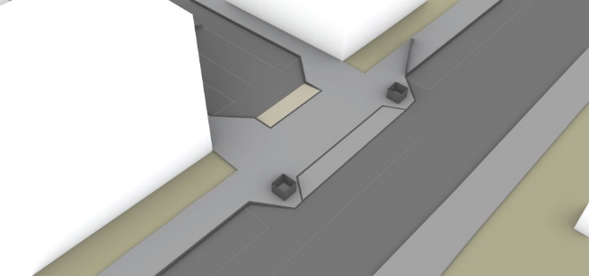
Image 2: Drury Street (at Renfield Street), Glasgow
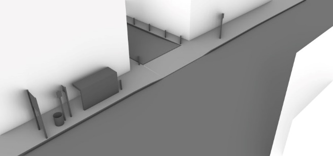
Image 3: Haddon Road (at Kirkstall Road), Leeds
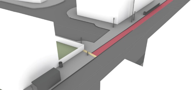
Image 4: Lansdowne Terrace (at Guilford Street), London
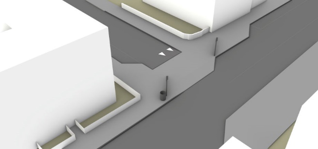
Image 5: Sauchiehall Lane (at Holland Street), Glasgow
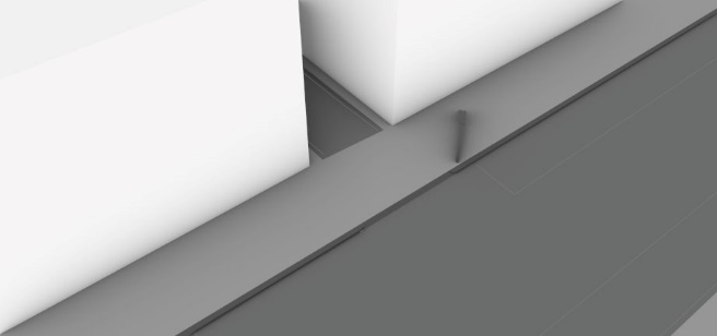
Image 6: Scott Street (at Sauchiehall Street), Glasgow
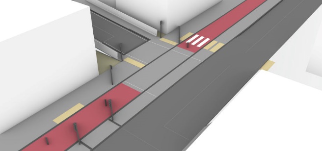
Image 7: Wilfred Street (at Buckingham Gate), London
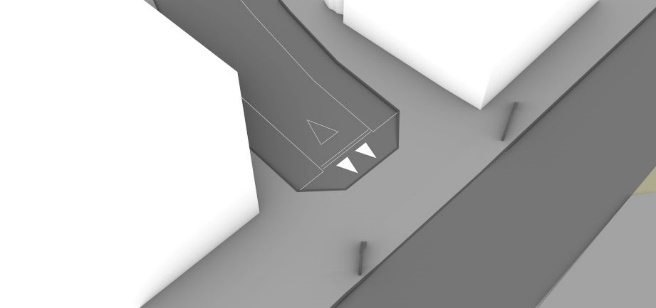
Image 8: Woodside Avenue (at Kirkstall Road), Leeds
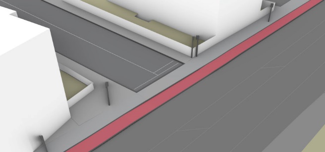
A number of repeat visits were made to some of these sites, enabling us to see them at different times of day and at different times of year.
Our in-person study (as distinct from the fixed camera analysis) of these sites included:
Careful evaluation of the context of each location
Recording the dimensions and features at each site, and producing simplified site plans
Taking a structured set of photographs for reference
Recording longer videos (up to around an hour in total) using hand-held cameras and temporarily-fixed wide-angle cameras
Recording our experiences walking and (sometimes) cycling through these sites
Taking structured and semi-structured observations and counts of vehicles and behaviour.
We carried out a count of different road users, with the aim of providing a general guide as to the level of use we were observing, rather than a detailed analysis.
Our approach was standardised, recording counts for ten minutes at a time. It was judged that these counts give a guide as to the level of use, and that this period was practical for in-person observation. At busier sites it was not possible for one researcher to record all traffic movement simultaneously. Instead, they recorded different aspects of use over two sequential 10-minute periods. This was a practical method to collect data from a 20-minute period (short enough so changes in level of use were small) but covering all users. At the busiest sites multiple observers were used to make this practical.
Where we saw more unusual behaviours, this on-site study also allowed us to take a record of how significant these were – for example at the Alderney Road site an unexpectedly high proportion of pedestrians were crossing the carriageway of Bancroft Road at the junction, and routes in and out of Alderney Road (the side road) appeared more important to drivers than routes along the “main” Bancroft Road.
Having this information meant that we were able to predict roughly what behaviours might be seen on the fixed-camera footage, and this also assisted in identifying the best locations for these cameras.
We used fixed cameras to provide footage of behaviours over a much longer period, using the services of the company Streets Systems. These were attached to a telescopic mast, which was held upright by attaching it to appropriate existing sign posts or lamp posts (i.e. lighting columns).
For most sites the cameras used provided four views, making it possible to cover multiple angles. Only one mast was used at each site.
Footage was recorded over at least two days, and often three days.
The footage allowed us (usually) to observe:
Whether pedestrians turned their heads in looking for vehicles
Whether pedestrians changed their walking or wheeling speed or rhythm
The routes pedestrians took through the site.
The limitations of the footage included:
At some sites we could not locate the cameras to see properly into the side road
We could not judge facial expressions or other similar details
We could not see the behaviours of drivers through the windows of their vehicles.
The main limitations in using camera footage are the same limitations that exist while observing behaviours in person.
Our analysis of fixed-camera footage included both informal and structured elements, both being important.
Supporting both elements, Streets Systems were able to use artificial intelligence to extract clips of video which show situations where pedestrians and vehicles cross the same area within a short time of one another. For all but the busiest sites, this made it more efficient to analyse interactions, meaning we did not need to watch the full length of the video footage.
Streets Systems also used artificial intelligence to provide:
Images onto which the paths of street users are traced, according to whether they belonged to certain categories (e.g. pedestrian, cyclist, car, van), combined into hourly and multi-day images
Heatmaps (repeating the above, but with brighter colours showing areas of high usage)
Counts of street users passing specific points (strictly speaking these were lines, not points), allocated to the above categories, and presented as graphs showing usage hour by hour.
We devised a structured process to allow an objective comparison of different sites.
Appendix 4 provides an explanation of the options considered for alternative analytical processes, and of the limits on structured analysis of behaviours at a side road junction.
In summary, the process involved:
Analysis of the experiences of pedestrians, counting each “pedestrian experience” where something notable happened (ignoring the others) rather than counting each interaction
Recording when we observed situations where we considered that what actually happened to pedestrians was unsatisfactory – assessed as a “Risk Level Actual” (RLA) measure
Using a measure based on simplified predictions of what a blind or partially sighted pedestrian might have experienced from an interaction – assessed as a “Predicted Vulnerability Indicator” (PVI) measure
Recorded indicators of “Observable Polite Driving” (OPD).
Our decision to focus on pedestrian experiences rather than interactions between pedestrians and vehicles was a practical one. The need for this arises for a wide range of reasons, which we describe in detail in Appendix 4.
The most important reason is because one pedestrian can interact with multiple vehicles, and one driver can interact with multiple pedestrians.
At busier sites such multi-pedestrian/multi-vehicle interactions were common. For example we repeatedly saw situations with:
Drivers giving way to pedestrians already crossing (because the alternative was to collide with them), with a number of pedestrians then feeling confident to cross in front of the stationary vehicle, partly because it was not moving and partly because other pedestrians had already halted its progress
Pedestrians crossing in front of a vehicle because the vehicle was stationary in a queue of traffic waiting to exit the side road
Pedestrians having an exiting driver give way to them, but with an entering driver continuing.
The character of these interactions cannot adequately be captured by a simplistic record of separate vehicle-pedestrian interactions (recording who gave way to who in each case). A balance was struck between over simplifying categorisation and creating an impractically high number of interaction categories.
For any study evaluating the effects of infrastructure design – overly-simplified approaches would provide misleading results, for example because:
Vehicle drivers are recorded as giving way to pedestrians while they wait in a line of traffic queuing to exit (perhaps because they don’t narrow the gap to a vehicle ahead), making a junction that is relatively difficult to cross appear to be prioritising pedestrians
Sites with very high numbers of pedestrians will show high levels of vehicle give-way behaviour (almost) irrespective of the design of the infrastructure (these sites changing character when there are fewer pedestrians)
Any count of the total number of interactions must either be highly subjective or limited in accuracy because many interactions can occur at a distance, with only subtle changes in driver behaviour (for example with a driver slowing slightly sooner so as not to intimidate a crossing pedestrian).
The last point is crucial. A well-designed junction might be one in which approach speeds are very low, and here there may be a much smaller number of interactions where pedestrians come close to vehicles – and a much larger number of distant interactions, where a driver makes only subtle changes in behaviour (avoiding a closer interaction). To be able to compare the performance of such a junction to one with a poor design both close and distant interactions must be counted.
In practical terms our process meant one record (in an analysis database) for every pedestrian or associated group of pedestrians (e.g. friends together) crossing, with a note made of the number of pedestrians in each group (with such a group sharing one common experience, but with this counted separately for each group member). For each experience, we recorded, where relevant, three key measures (RLA, PVI, OPD) as described below.
The “risk level actual” (RLA) measure records actual problematic or unsatisfactory events, at two levels. The lower category (nominally recorded as “probably risky or worrying” or “prA”) includes situations where we felt that a pedestrian was probably at some risk and situations where we thought the pedestrian was probably worried by what happened or by the conditions they experienced. The higher category (nominally recorded as “definitely risky or scary” or “drA”) includes situations where we felt that a pedestrian was more at risk or was definitely alarmed or scared by the situation.
There is the potential for a high level of subjectivity in this measure. To ensure that we were working as objectively as possible we recorded a table indicating what events should be classified within this measure, and what events fitted within the lower or higher category. This is shown below as Table 3.
Note that this RLA measure is designed to be sensitive to problematic issues that might exclude some pedestrians, rather than being a way of evaluating actual risk as “moderate” or “high”. Many pedestrians can be seen in our footage to be dealing well with what we classified as more risky or difficult situations.
In this web page version of the report Table 3 has been converted into text. The text lists three classification codes and their meanings.
Classification code “sA” meaning situations not to be classified as risky or worrying/scary:
Pedestrian showing something from this list:
continues without changing speed or direction
has to walk around a stationary car which is in the way
walks between queuing cars if there is no vehicle movement
walks in front of a waiting vehicle, or between waiting vehicles, using the drivable space (i.e. the space intended both for driving and pedestrians) without leaving the drivable space, if there is no vehicle movement
diverts off drivable space behind waiting vehicle if this is stationary or almost stationary
runs (rather than walks) out of politeness (not out of fear).
Classification code “prA” meaning “Moderate” problems. In other words situations to be classified as “probably risky or worrying”, but which are not sufficiently so to be classified as “definitely risky or worrying/scary”.
Pedestrian showing something from this list:
steps into the main carriageway or associated ramp to pass in front of a waiting vehicle
appears to nearly walk into the side of a slow moving car but notices the risk at the last moment
walks in front of a waiting vehicle, or between waiting vehicles, using the drivable space (i.e. the space intended both for driving and pedestrians), without leaving the drivable space, if there is minor vehicle movement
probably could have crossed in time, but unusually high vehicle speed, large vehicle size, or other similar factors meant they chose not to try
show any signs of fear, or more raised concern for the welfare of small children, than is typical on crossing a road
alters direction, even a little, as a result of concerns about a vehicle pointing toward them
stops abruptly, but it looks like they were actively aware they might need to (e.g. walking quickly and looking actively up the side road as visibility becomes possible)
stops short of what is intended to be the drivable space because a vehicle entering or leaving the side road is driven outside that area (if they need to step back, this is recorded as drA).
Driver showing something from this list:
commits to a manoeuvre that they need to complete for their own safety, while pedestrians are very close to the drivable space (but there is no actual risk of a collision)
commits to entering the side road thinking they are clear to do so, but then has to hold, blocking traffic on the main road
holds short of hitting someone, is clearly aware they are there well before any risk of actually hitting them, but is assertive in driving as if the person is inconveniencing them.
Classification code “drA” meaning “Higher” risk problems. In other words, situations to be classified as definitely risky or scary/worrying.
Actual collision (none seen)
Pedestrian showing something from this list:
acts in alarm
takes a step back, or they stop abruptly if it seems they did not expect to need to do so
has to move back or sideways because a vehicle is encroaching in their space
uses the main carriageway to cross in front of a vehicle
runs, out of fear or worry
would have been stuck in a space one driver was expecting to travel through, had a driver travelling in the opposite direction not stopped their vehicle to allow progress
walks in front of or between waiting exiting vehicles if there is at the same time a risk from vehicles entering, including if a driver is waiting for a gap in traffic on the main road which will allow them to enter.
Driver showing something from this list:
commits to a manoeuvre they will be forced to carry out for their safety (because of another moving vehicle), and had the pedestrian not stopped, collision with one or the other seemed possible
commits to a manoeuvre to enter the side road, which they will be forced to carry out for their own safety, while a pedestrian is dealing with or emerging from negotiating exiting vehicles into the space the entering driver is needing to use.
A second driver does not hold clear despite the pedestrian dealing with negotiating a waiting exiting vehicle.
The PVI measure seeks to provide a guide to the kinds of problem that might be faced by pedestrians who are blind, partially sighted, or who are less able to negotiate more complex and risky interactions with vehicles. This is not a measure of what happened, but a greatly simplified prediction of what might have happened had each pedestrian been blind or partially sighted.
Clearly any actual attempt to predict people’s experiences would be entirely subjective, and likely inaccurate, so it is important to emphasise that this measure is not an actual prediction of what experiences blind or partially sighted people would have at these locations. Instead, the PVI measure used a set of more objectively observable factors to provide a broad numerical indication informing us about how well a junction was prioritising pedestrians. It does this by asking whether a pedestrian who assumed they were on a footway, and who continued without taking notice of any threat from vehicles, would encounter problems.
Specifically, the PVI measure asks what would have happened had the pedestrian we observed in the footage been blind or partially sighted, had they continued ahead at the junction without changes to speed or direction of travel. It makes the assumption that the pedestrian has no awareness of a potential collision with a vehicle, and that they take no avoiding action. It also assumes that the drivers of the vehicles involved behave exactly as captured in our footage, and that they do not take any additional action (over and above the way they were observed behaving in reality) to avoid a problem or collision – even as the potential for one became obvious.
Table 4 shows the indicators that could be selected for the PVI measure. More than one indicator could be chosen for recording each pedestrian experience.
In this web page version of the report Table 4 has been converted to a list to aid accessibility. Each item in the list includes the PVI code, what this signifies, and a longer explanation.
Table 4 includes the following warning text: Take note that the PVI measure explanations are not predictions of actual experiences but instead indicators based on assumptions to provide an objective numerical measure of junction performance.
HbC, “hit by car” , Pedestrian would have walked in front of a moving car sized vehicle
HbL, “hit by larger” , Pedestrian would have walked in front of a moving larger vehicle
HBl, “hit by bicycle likely” , Pedestrian would probably have been hit by a bicycle
HBr, “hit by bicycle risk” , There would have been some risk of a collision with a bicycle
TdMB, “touching distance moving bicycle” , Pedestrian would have walked within touching distance of a moving bicycle, but there would have been no collision
TdMC, “touching distance moving car” , Pedestrian would have walked within touching distance of a moving car sized vehicle, but there would have been no collision
TdML, “touching distance moving larger”, Pedestrian would have walked within touching distance of a larger moving vehicle, but there would have been no collision
WiMC, “walk into moving car”, Pedestrian would have walked into the side of a moving car sized vehicle (any movement)
WiML, “walk into moving larger”, Pedestrian would have walked into the side of a moving larger vehicle (any movement)
WiSC, “walk into stationary car”, Pedestrian would have walked into the side of a stationary car
WiSL, “walk into stationary larger”, Pedestrian would have walked into the side of a stationary larger vehicle
The “observable polite driving” (OPD) measure is a way to record when we could see that drivers behaved politely. This tries to distinguish between drivers giving way because they are effectively forced to do so, from situations where they had chosen to give way (i.e. explicitly acknowledging the priority of the crossing pedestrians). It also allows a record of situations where drivers were effectively forced to give way, but where they did so with apparent politeness.
Table 5 shows the indicators that could be selected for the OPD measure. More than one indicator could be selected for one pedestrian experience.
In this web page version of the report Table 5 has been converted to a list to aid accessibility. Each item in the list includes the OPD code, what this signifies, and a longer explanation.
Hg, “holds leaving gap”, Driver holds (stationary), leaving a gap in front of them on the drivable space (i.e. the area intended both for driving on and for pedestrians) which the pedestrian uses
Hm, “holds moving”, Driver holds clear of the drivable space while continuing to move, but moves in a way that appears to be intended to allow a pedestrian to cross at their established speed
HJc, “holds just clear”, Driver holds (stationary) just clear of the drivable space (with the vehicle partly on this, or otherwise dominating the space because it is close to the pedestrian)
HVc, “holds very clear”, Driver holds (stationary) very clear of the drivable space (or at the edge of this space where the result is that they are sufficiently distant from the pedestrian not to dominate the space)
Details of our analysis for each detailed-study site are in Appendix 2. This section presents four key graphs summarising observations and problems.
Figure 10 compares the numbers of pedestrians and vehicles crossing the drivable space, broken down to show the maximum and minimum numbers observed in any hourly period (in our study period of 7am to 7pm). (Note that vehicles at Lansdowne Terrace were mostly bicycles.)
The balance between vehicle and pedestrian numbers helped to determine the character of the environment at each site, but note that peak/minimum pedestrian/vehicle numbers did not necessarily occur during the same study hour.

Figure 11 shows a graph on which actual problematic pedestrian experiences – flagged as including moderate or higher level problems according to the RLA measure – are plotted against the number of vehicles crossing the drivable space.
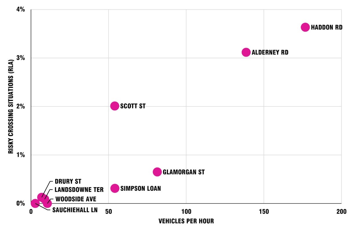
Figure 12 shows a graph recording situations for a pedestrian that we classified as problematic according to the PVI measure, plotted against the number of vehicles crossing the drivable space.
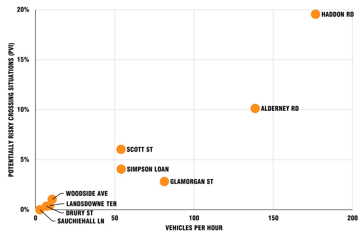
Figure 13 shows a histogram illustrating the percentage of pedestrian experiences that we flagged for each site as including moderate (pale pink) or higher level (dark pink) problems, according to the RLA measure, broken down to show the balance between these two categories.
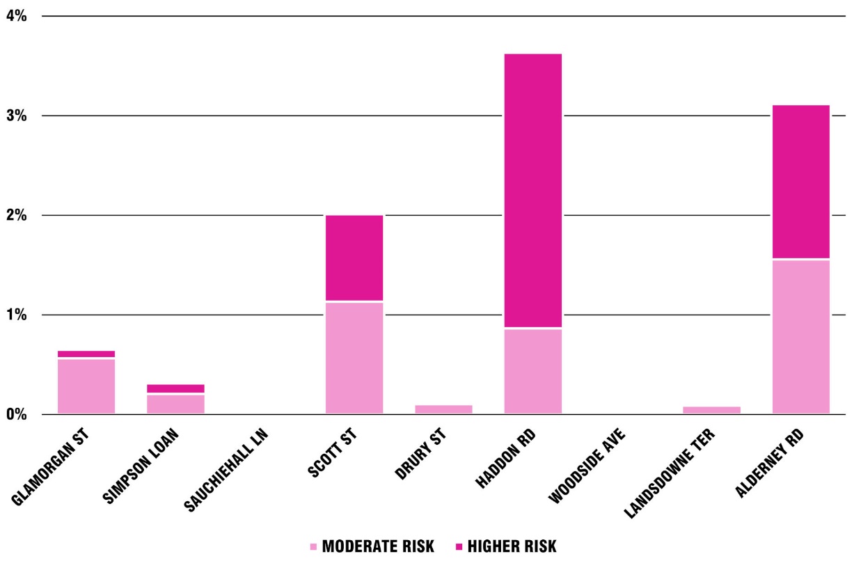
It was established that problems existed at almost all our study sites. We did not speak to those involved in designing our detailed-study sites, but the evidence shows almost all fail to establish the degree of pedestrian priority which we consider designers were aiming for.
There is no doubt that at most of our study sites the design completely fails to create a situation where pedestrians “don’t even have to look up” – which was clearly stated as an aim by one of our key designer informants. This is consistent with previous studies, which show a wide range of conditions at different locations, with at some sites a high number of situations where drivers forced pedestrians to yield (see the literature review for details).
Our conclusion is that critical factors in these designs not achieving priority for pedestrians include:
The failure to force very slow vehicle speeds
The provision of these designs in locations where drivers are approaching too fast
The provision of these designs in locations where drivers do not feel able to comfortably slow down or stop
The failure, in some locations, to convince drivers, via visual clues, that they are mounting / crossing a footway
The provision of these designs in locations where there is too high a level of traffic movement.
Figure 11 and Figure 12 in the sub-section above show that the number of actual riskier experiences for pedestrians (RLA) that we observed, and indeed the number of experiences we predicted would theoretically have caused problems for some disabled pedestrians (according to our PVI measure), were on the whole just products of the number of vehicles entering or exiting the side road.
It can be seen from Figure 13 that at some of the sites at which higher numbers of vehicles were crossing between 2% and 3.5% of pedestrian experiences were flagged as problematic according to our RLA measure.
In some cases it was quite common to observe pedestrians who looked like they were struggling or who appeared concerned or frightened by the conditions they were facing. We could not capture objective data about fear, but as observers saw situations at some of the busier locations which alarmed us.
Unsurprisingly, at quieter locations there were fewer problems for pedestrians. For example, we recorded:
No interactions between pedestrians and vehicles in three days of video at the crossing of Sauchiehall Lane (at Holland Street)
No difficult interactions (RLA) at the crossing of Woodside Avenue (at Kirkstall Road).
Pedestrians made adaptations to their behaviour at locations where this was necessary to stay safe, for example:
At some sites, at times, pedestrians could be seen behaving with particular caution, looking carefully for oncoming vehicles before crossing – and at busier sites lining up in groups, waiting to cross
At sites where there were vehicles queuing to exit, pedestrians usually moved slightly into the side road, leaving the area intended for their use (the drivable space), in order to cross behind or between vehicles
At busier sites, pedestrians could sometimes be seen crossing slightly into the side road, distancing themselves a little from entering vehicles.
Pedestrians could also be seen taking decisions based on only the very briefest of glances, and we suspect that on many occasions people were utilising additional information, such as from the sound of traffic. They also sometimes seemed to be making complex calculations, for example by judging that an exiting queue of traffic was about to move.
On many occasions pedestrians were observed making sudden judgements about how to stay safe, for example:
Suddenly stopping when a vehicle passed close in front of them
Stepping backwards to keep clear of an entering vehicle which had encroached onto the space they had been standing on.
This adaptability of most pedestrians can create a misleading situation where infrastructure looks to be well-designed because most cope with using it, and injury rates are low. However, the specific impairments of some disabled people mean they do not have the same information available to them, or power to act as easily to stay safe. Some others have impairments to their mobility which limit their options physically. And a third group, which includes younger (non-disabled) children and some neurodiverse people, are less able to make the more advanced judgements needed to stay safe or to make progress in these more complex situations.
We saw many interactions between drivers and pedestrians in which it was evident that the driver was responding on the fly to the situation that had emerged ahead of them. In such circumstances it was obvious that the driver was giving way, sometimes by reacting very quickly, in order to avoid hitting a pedestrian who had walked into their path.
Such interactions are of a different character to those in which a driver gives way in anticipation of a pedestrian:
Arriving and wishing to cross
Intentionally walking into their path (perhaps asserting their presence to force the driver to give way)
Walking into their path accidentally (having not noticed either the drivable space or the presence of the oncoming vehicle).
While the differences between these interactions were sometimes obvious (subjectively), there were also many interactions that could not easily be categorised – there being no objective method for an observer to determine whether a driver was anticipating a need to give way, giving way voluntarily, or giving way because the alternative was to run into the pedestrian.
There are locations where pedestrians are, at least commonly, being prioritised, and where the level access provided by continuing the footway has advantages for all users. The situation at Sauchiehall Lane was a good example, as was that at Drury Street (also in Glasgow).
At Sauchiehall Lane, the low levels of vehicle use mean that it is very unlikely that a pedestrian and vehicle will meet, while the ramp and constrictions of the lane force vehicles to be driven very slowly.
For the purposes of general navigation, it is important for the presence of side roads to be detectable by blind and partially sighted pedestrians. However where very minor entrances, like to Sauchiehall Lane, exist in an otherwise complex and compact streetscape it seems unlikely that the loss of the detectability of this lane will lead to problems.
Our data shows where traffic is very low and the time traversing a continuous footway across a minor entrance/exit like this is short, the risks of negative experience are minimal. Meanwhile, the level surface and the ability to proceed without any pause or worry are an advantage.
At Drury Street, the high levels of pedestrian traffic, low level of use by vehicles, and constraints provided by the narrow lane, effectively create pedestrian priority. However, there were some unsatisfactory interactions observed here, and the success of this particular continuous footway is qualified. The absence of a steep ramp, and the width of Renfield Street at this point, mean that vehicles could take a relatively fast and/or sweeping path on entering, or could cross the drivable space at odd angles (i.e. more parallel to the footway rather than pointing their vehicle more obviously along the line of the lane).
At junctions where there are a large number of pedestrians present, particular behaviours emerged. Based on an informal analysis, we concluded that these included the following:
Drivers were more likely to be more cautious when they could see lots of pedestrians ahead of them. We suspect that the presence of a number of pedestrians becomes much more obvious than the presence of a single pedestrian; also that it becomes much more difficult for an approaching driver to interpret and predict behaviours as the number of pedestrians increases.
Where there were more pedestrians, there was a much greater chance that a driver arrives when pedestrians are crossing the space they wish to drive over. In these circumstances almost every driver held back, and where necessary to avoid causing injury, stopped to wait. This created a situation where following pedestrians were confident to cross, meaning the driver waited for them too.
Individual pedestrians in larger crowds may be taking less notice of a junction, relying on the responses of people around them rather than carefully checking for themselves for oncoming vehicles.
We saw no evidence that the presence of structures that appear to continue the footway, but which don’t also restrain vehicle speed and path, automatically lead to good driver behaviour.
Examples include the performance of the structures at the end of Alderney Road (with Bancroft Road) in London and at the end of Haddon Road (junction with Kirkstall Road) in Leeds. The Alderney Road structure is of a different colour to the carriageway, matches the footway, and is raised to footway level. In contrast, the Haddon Road structure is visually insignificant, as both footway and carriageway are asphalt, and this is flush with the carriageway. Yet we recorded a rate of problematic situations which was roughly comparable at both sites once the higher levels of traffic at Haddon Road were considered.
Conditions observed in this study were consistent with observations from previous studies about the higher number of problematic situations caused by vehicles entering the side road (in comparison to those exiting). In observing behaviours, we concluded the following:
Entering drivers might not be anticipating a need to stop, so they maintained a higher speed if they could. Exiting drivers were already anticipating a possible need to stop at the main road, if only for their own safety, and this seemed to make them more inclined to stop.
Some entering vehicles could only be seen by pedestrians looking behind (i.e. over their shoulder), whereas exiting vehicles could be seen by looking to the side.
It seemed to be difficult for pedestrians to separate out which drivers were intending to turn, within a stream of approaching vehicles. Not all drivers indicated, and even if they did it takes longer for a pedestrian to look for this than to spot a vehicle leaving the side road.
Vehicles on the main carriageway were likely to be approaching faster, meaning that predictions about the intention of their drivers needed to be made at a greater distance.
Conditions on the main carriageway made a difference to how drivers behaved on turning right into a side road. In busier traffic, most obviously at Haddon Road, these drivers faced a choice between waiting a longer time and taking a greater risk. We could see drivers sometimes made a turn judging that they would be able to clear the main carriageway before a collision occurred (notably sometimes in front of large, fast-moving vehicles). It seemed unlikely that those drivers, under considerable pressure to make that one judgement accurately, had accounted for pedestrians crossing.
We observed pedestrians taking account of such a situation by waiting to cross.
Situations where there is traffic queuing to exit the side road produced quite a different environment for pedestrians, in comparison to those where exiting vehicles were rarer.
The environment created by queuing exiting vehicles could be difficult and problematic, for example:
Vehicles were physically in the way
Pedestrians had to account for the risk that vehicles move unpredictably, for example rolling backwards or forwards (with a risk of being crushed between vehicles)
The presence of queuing vehicles visibly dominated the junction
Pedestrians needed to deal with both queuing and entering vehicles simultaneously.
Figure 14 illustrates conditions created when four vehicles were queuing to exit Haddon Road in Leeds. The driver of the blue car has been waved into the road by the driver of a small white lorry, and the driver of a black car (nearer to the camera) has stopped in response. Typically pedestrians here could be seen, in such circumstances, to move into the side road, passing between vehicles further back from the intended crossing point at the end of the side road while at the same time taking care to watch for vehicles turning in.
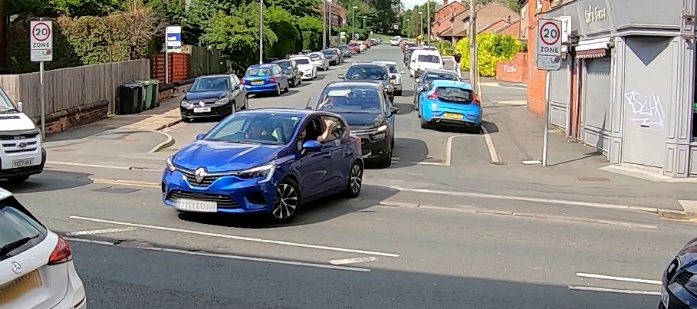
Situations where pedestrians were simultaneously negotiating entering and exiting vehicles were of a very different character to those where they were only dealing with a threat from one direction. The problems included:
The need to watch for traffic from multiple directions
The need to judge the behaviour of more than one driver at one time
The reduced availability of options when making a mistake
Crossing pedestrians could be hidden from entering vehicles by the presence of exiting vehicles
The view of entering vehicles was blocked for pedestrians by exiting vehicles.
Figure 15 shows images extracted from video footage of two-way traffic movement at Alderney Street (London) and Glamorgan Street (Cardiff). In both cases pedestrians are faced with complex vehicle movements, and drivers are negotiating conditions in which they are focused on avoiding damage to their vehicles.
Image 1: Alderney Street in London
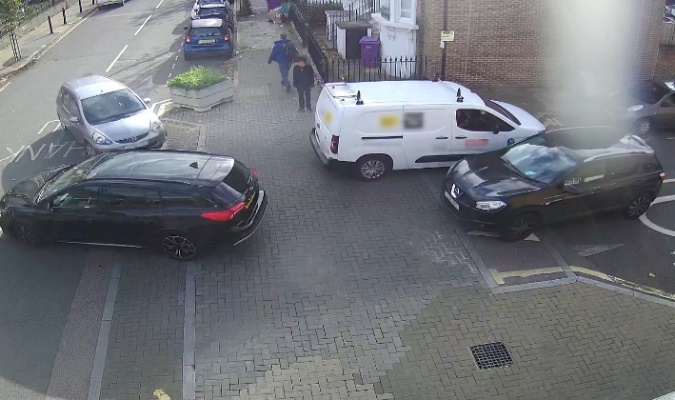
Image 2: Glamorgan Street in Cardiff
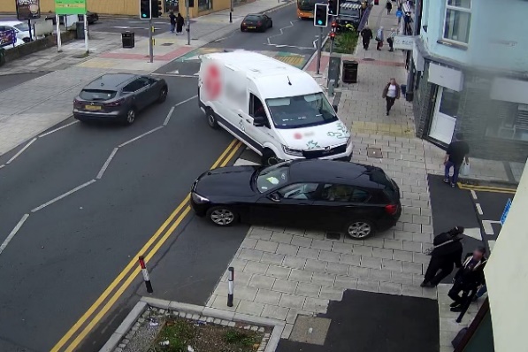
Researchers judged that vehicle approach speed from the side road had an effect on pedestrian behaviour. We did not attempt to assess vehicle speed objectively because of the prohibitively difficult technical challenges involved in doing so. Effects were observable by noting the differences in the behaviour of different drivers at an individual site – with vehicles approaching faster or more slowly.
When vehicles were approaching faster, pedestrians were more cautious. We theorise that this added caution arises because people wanted to be confident about having sufficient time to cross safely, and because they may have considered that drivers of faster vehicles would be less likely to stop.
A vehicle approaching faster seems sometimes to cause pedestrians to hold back for a disproportionate length of time, giving way before this is strictly necessary. Pedestrians need to respond to these faster moving vehicles while the vehicles are much further away from the junction, making judgements more difficult. Adding a margin for error in such circumstances has a bigger effect than when a vehicle is approaching more slowly.
Our observations on the effect of approach speed on the main carriageway are more limited. Determining whether pedestrians were responding to subtle signs that a driver was intending to turn into the side road was challenging. However, it seems self-evident that approach speed has an effect. We theorise some drivers may assume speed (and momentum) gives them priority over crossing pedestrians.
For pedestrians it can be difficult to judge which vehicles are turning into a side road given:
Any increase in traffic levels, because there are more vehicles to look at
Even small increases in approach speed, as these mean that judgements need to be recalibrated, especially if a vehicle is accelerating or decelerating
Drivers considering giving way to a pedestrian may be less comfortable in holding up others when in heavy traffic
Drivers considering giving way may feel less safe doing so if in faster moving traffic
Drivers turning right across traffic are under greater pressure when approach speeds and levels of traffic are higher.
Our literature review noted that previous studies provide evidence that the most problematic pedestrian-vehicle interactions occur when drivers are turning right from the main road into the side road. At our detailed-study sites the problems with “right turn in” movements included:
Drivers taking a relatively fast, sweeping turn, maintaining speed
Drivers choosing to take the right turn in front of larger or faster oncoming vehicles, relying for their safety on their judgement that they would be clear of the main road before there was any collision
Some of the drivers we saw turning right seemed to be preoccupied with looking for a suitable gap in traffic, consequently paying little attention to crossing pedestrians.
Informal observation of whether drivers gave way at the position officially marked with white dashed give-way line markings, suggested that, in the absence of pedestrians:
Many drivers did not actually stop their vehicles at all, even when giving way to other traffic – continuing to move slowly, judging when they could continue, and only stopping when there was no other option
Those drivers who did stop their vehicles to give way, did so at the point when they could not keep moving without inconveniencing or alarming drivers in oncoming traffic.
At some of our study sites exiting drivers had very little time to respond to pedestrians intending to cross, as these pedestrians emerged from behind walls, or parked vehicles. This influences whether drivers give way, as many did not have the opportunity to do so. This problem was, of course, worse in the case of higher approach speeds.
Figure 16 illustrates the difference between two designs (showing a raised side road entry treatment rather than a continuous footway). The first creates a situation where a pedestrian can step onto the raised section of carriageway having taken only one or two steps after becoming visible to a driver. In the second image the pedestrian is visible to a driver for three or four times as long before they step onto the carriageway.

We chose one study site, at the junction of Simpson Loan with Chalmers Street in Edinburgh, to study this effect (Figure 16 is roughly modelled on conditions here).
Pedestrians crossing Simpson Loan while walking north (in a situation as shown in the left image above), typically take only around two steps between them becoming visible to an exiting driver, and them stepping onto the space used by vehicles. A wall blocks visibility of pedestrians, and their views of approaching vehicles. Southbound pedestrians are visible for very much longer (being in a situation roughly equivalent of that shown in the right image – although the build-out section of footway here is even longer than that illustrated).
There were many situations in which exiting drivers had insufficient time to respond to northbound pedestrians, however we recorded few situations where pedestrians were at risk because they stopped and looked as at any other junction (this site having been chosen as an example of a side road entry treatment rather than as an example of a continuous footway).
On the other hand, southbound pedestrians are visible for a protracted period before arriving at the crossing point. However, we saw little evidence that increased visibility of southbound pedestrians on its own led drivers to give way more often. There were some occasions when drivers appeared to behave in a way which allowed southbound pedestrians to cross by driving more slowly toward the junction – but such effects are very difficult to quantify.
Appendix 2 provides an additional commentary on the ramp designs (or lack of ramps) at our detailed study sites, the gradients and heights of these, information about Dutch entrance kerbs and their use in exit constructions, and the availability of different entrance kerb units in the UK.
Subjectively, it appeared that at most of our detailed-study sites vehicles could be driven at a problematically high speed over the crossing point (drivable space).
Speeds were not measured because of the level of technical challenge involved. This difficulty relates to the need to gauge the changing profile of vehicle speed over the infrastructure rather than the speed at any one easily identified point.
Figure 17 shows ramp design, or the lack of a ramp, at Sauchiehall Lane, Wilfred Street, and Scott Street. More images are provided in Appendix 1 and 2.
Image 1:
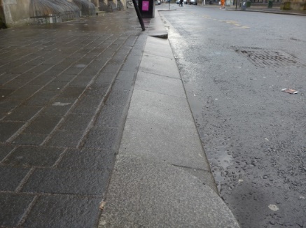
Image 2:
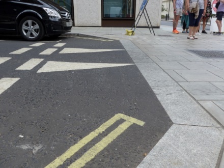
Image 3:
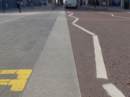
Self-evidently, sufficiently steep and high ramps, bringing the carriageway to footway height, force drivers to moderate their speed to avoid discomfort or even minor damage to the vehicle.
In some locations there were no ramps provided or these were in an unhelpful location. At the junction of Scott Street and Sauchiehall Street in Glasgow (the third image in Figure 17) there is a ramp on the main carriageway (raising the main carriageway to the level of the surrounding footway, leaving no difference in height at the location where ramps were used at those other sites where they were included). This ramp was of a gently sloping design, and some vehicles here did not slow at all. The raised carriageway allowed problematically fast, sweeping turns into the side road. The design at Drury Street in Glasgow also has no ramps. In Walthamstow the standard designs lack ramps.
Where ramps were present we looked to see if drivers noticeably slowed down, for example to a walking pace, but did not see any evidence of this being a consistent and predictable effect – other than at Sauchiehall Lane. We thus judge that the ramps elsewhere were not steep or high enough.
In Section 8, Discussion of core findings, we suggest that good continuous footway designs will always include ramps which are sufficient to slow vehicles to around walking pace.
Problematic situations were seen to arise at sites where drivers were able to negotiate the turn into or from the side road in a sweeping curve.
Figure 18 illustrates the effects on vehicle path of tighter corner radii at a standard side-road junction. A slight tightening of corners, as shown in the second image, might mean a driver having to slow their vehicle before entering the side road. The third image shows that a more severe tightening of corners might make it necessary to slow a vehicle considerably just to negotiate the junction without risk of damaging the vehicle. A positive side effect of this layout is that tactile paving and kerbs, and the slope on any dropped kerb arrangement, define a clear direction for crossing (rather than pedestrians crossing at a point where these are at an angle to their direction of travel).
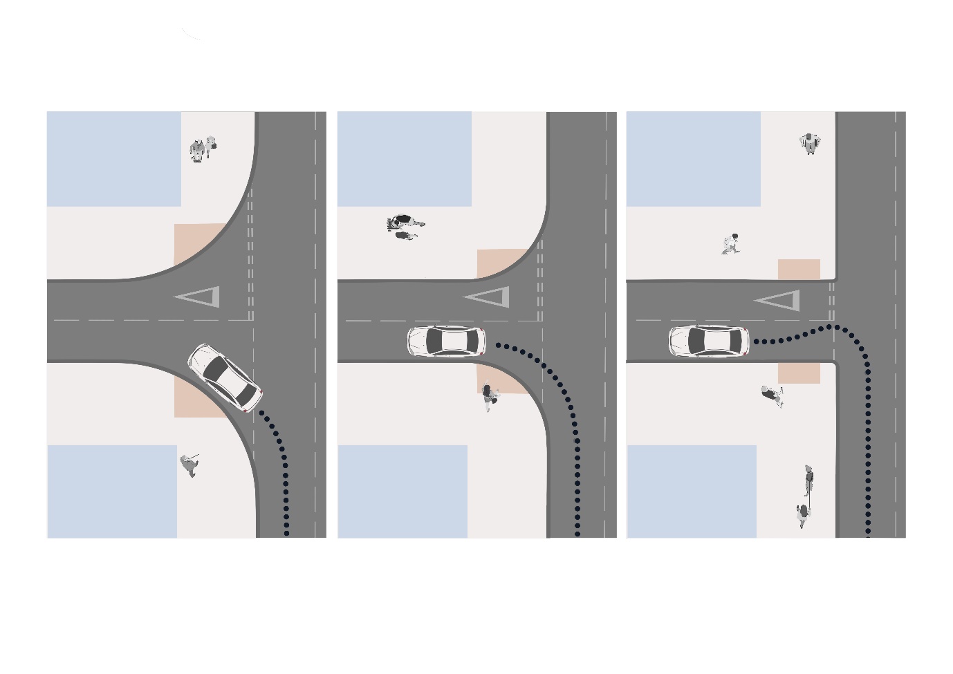
Figure 19 illustrates the problems seen at the Scott Street junction (with Sauchiehall Street). The left image is taken from the fixed camera, and beside this the right image shows traces, superimposed on that image, indicating the paths taken by cars entering the side street here (the numbered arrows indicate points used to analyse vehicle and pedestrian numbers). It can be seen that vehicle drivers are free here to follow a sweeping curve as they cross the drivable space.
Image 1: Photograph with no traces
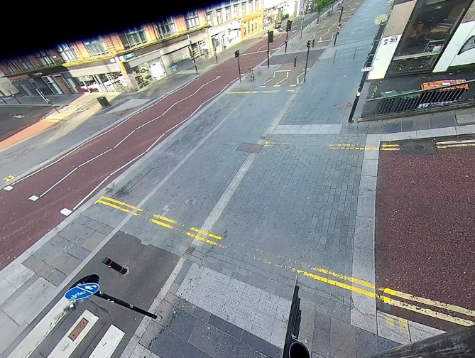
Image 2: Photograph with traces superimposed on it
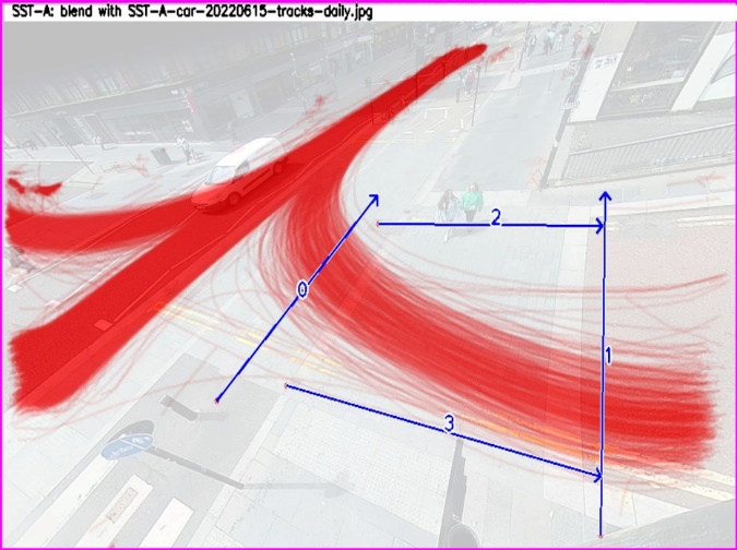
Figure 20 shows images from the fixed camera used to study the site at Glamorgan Street (at Cowbridge Road East) in Cardiff. Problematic conditions were sometimes seen here – particularly when vehicles were both entering and exiting simultaneously. However, some constraints to vehicle path – not least caused by the width of Glamorgan Street when vehicles are travelling in both directions – are evident.
Image 1: Photograph with no traces
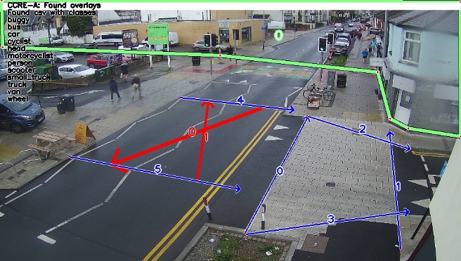
Image 2: Photograph with traces superimposed on it

Figure 21 shows a sequence of images from the fixed camera at Haddon Road, Leeds. In these it can be seen that
The car entering the side road is in heavy flowing traffic
The vehicle path is a sweeping curve, encountering the area the pedestrians are walking well before this is lined up for travelling along the side road
The vehicle effectively arrives from behind the pedestrians
Because there are no exiting vehicles the driver is able to use part of the “wrong” side of Haddon Road as part of the sweeping curve.
Image 1
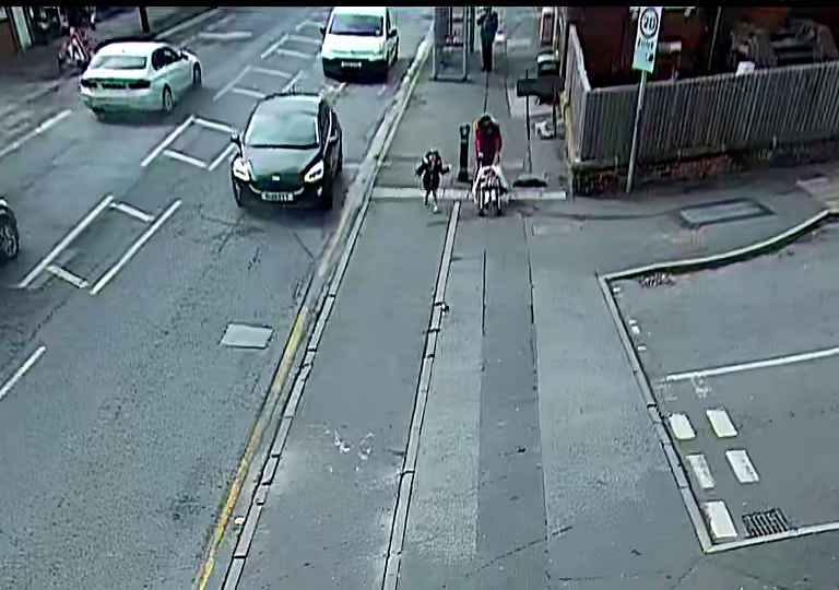
Image 2
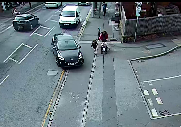
Image 3

Image 4
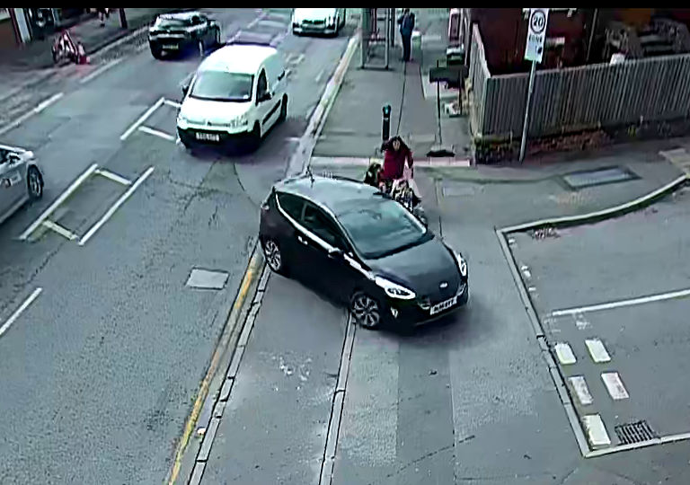
This project has yielded evidence that structures being called “continuous footways”, on wider busier public side road ends, are failing to provide a high degree of priority for pedestrians.
The project team spent many months observing the behaviours of both pedestrians and drivers, investigating how different infrastructure hindered or benefitted pedestrian movement and safety. There were times when we saw positive driving behaviour, which matched design aspirations, only for us to then witness the power of an individual impatient driver to undermine any sense of pedestrian safety and comfort. It is apparent that the fine details of design can have a crucial impact on whether designs prioritise pedestrians, but it is also evident that wider street and traffic conditions have an effect too.
In reporting on this study there is a fine line between describing the problems observed with new infrastructure, and the risk that such criticisms will be taken as a defence of the status quo. There are important lessons to be learned, but it is equally crucial to acknowledge that existing streets (without continuous footways) exclude or intimidate a wide range of pedestrians, and consider pedestrian priority as, at best, an afterthought.
If what has been tried isn’t working well then this raises important questions about alternatives. There are some obvious simple changes that might help to improve matters a little. These include the addition of dropped kerbs, tactile paving, signalised crossings (i.e. with traffic lights), and additional maintenance. However, it seems highly unlikely that traffic signals can be added at every busy side road junction, and while adding dropped kerbs and tactile paving is essential it does nothing for the overall priority of pedestrians. This research highlights the need for much wider changes to our streetscapes, including at side road junctions and entrances. We have considered where the idea of a continuous footway fits (and doesn’t fit) with this, and what design details are important.
With a view to drawing together the many threads of a complex project, this section is framed as a discussion, organised in themes. This includes both conclusions and recommendations. Many of these are high-level, but some provide important supporting findings of detail.
The main conclusions and recommendations are listed separately in the final section, “Summary of main conclusions and recommendations”.
The literature review determined that there is a high degree of confusion over what is, and what is not, a continuous footway. This was confirmed in conversations with designers, and from evidence throughout the rest of the project work.
This complicates any discussion over the effectiveness of continuous footways, and about how they should be designed. The resulting lack of design standardisation also has real-world effects.
However named, there are a growing number of side-road junction treatments where new designs – often with some similarity to continuous footways – have decreased or removed the distinction between carriageway and footway.
For more details about the level of confusion over terminology and the lack of standardisation, please refer to information in the accompanying literature review, and on conversations with designers (Sections 3 and 5.3).
Based on consultation interviews, work with disabled people, and the detailed-study site work, it can be concluded that
different designers of continuous footways – or designs being called continuous footways – may have had quite different objectives
outcomes for users are not necessarily in line with designer expectations.
There appear to be three principal strands in terms of designer intention. These are that behaviour would be changed by:
creating ambiguity between what is footway and what is carriageway (leading to everyone being careful and looking out for one another)
creating an unambiguous continuation of the footway (leading drivers to behave carefully simply because they feel they are driving over footway)
creating an unambiguous continuation of the footway, but with behaviours determined as much by strong constraints on vehicle speed, path, and movement complexity (i.e. both forcing vehicles to slow and using appearance to encourage cautious driving).
Designs can be seen to fail in different ways when compared to the designer’s intentions. Problems may arise because:
The theory was wrong or incomplete. For example, some designs fail despite creating ambiguity and others fail even when they appear to have created unambiguous continuations of the footway.
A design is intended to create one effect but creates another. For example, some designs intended to create unambiguous continuations of the footway in reality create an ambiguous drivable space, or simply something that to drivers seems to be part of the carriageway.
The physical constraints on driver behaviour are insufficient. Some designs can be seen to have ramps that fail to slow vehicle speeds, or a design allowing drivers to enter the side road driving at speed in a wide sweeping curve.
The volume or speed of traffic using the streets is too high. We saw similar designs used on different streets performing very differently, because of the number of vehicles using them or their speeds.
The last point is a particularly important one. Our study showed that different behaviours arose at sites that appeared similar, but where overall traffic conditions were different – or at single sites as traffic conditions changed during the day. This points to questions that are wider than about design principles.
This study observed failures to prioritise pedestrians but also found evidence that continuous footway designs may be useful in some places. Some lessons can also be applied to the design of footway crossovers. Our broad observations are:
Most of the infrastructure currently being called a continuous footway, or which attempts to continue the footway over the end of wider side roads in Britain, does not successfully prioritise pedestrians over vehicles. This has implications for inclusion.
Pedestrians are disadvantaged where the footway appears to continue, but drivers still assume priority crossing the drivable space.
Pedestrian priority is reduced where traffic volumes and speeds are higher
While some continuous footway designs clearly fail to prioritise pedestrians, there are locations where there are more benefits than disadvantages arising from the use of ‘real’ continuous footway designs (which create unambiguous continuations of the footway).
Features of good quality ‘real’ continuous footway designs at the end of public side roads would also have value if used to improve footway crossovers to/from a private area or access.
The clearest examples of positive effects were on Sauchiehall Lane in Glasgow – a location with low vehicle use and strong constraints on vehicle speed and movement.
For more information, please refer to sections reporting on work with disabled people and on our detailed-study sites (Sections 6 and 7).
The study raises questions about how to improve those locations where infrastructure can currently be seen to be less inclusive than desired.
A key question investigated was in relation to the use of tactile paving at continuous footways. Guidance is currently contradictory, and many of the concerns raised with us were about the absence of tactile paving at continuous footways in Britain.
As noted throughout this report, at most of the detailed-study sites pedestrians were not being provided with unambiguous priority. There were also regular situations where they needed to respond to risks from vehicles to maintain their safety. In such circumstances, as a minimum alteration, a standard arrangement of blister-style tactile paving should be retro-fitted to the kerb free edge of the area so that blind and partially sighted people can know to stop before crossing the path of vehicles. Mapping the problem, and developing local retrofit programmes is a matter of urgency in terms of inclusion and safety.
This conclusion applies equally to sites with footway crossovers (providing vehicle access over the footway to private sites) where high numbers of vehicles cross the footway (for example at entrances to petrol stations and car parks), especially where crossover design allows for faster vehicle speeds.
This is an important conclusion, but it does not imply that standard tactile paving arrangements should necessarily be used where it is possible to create more effective continuous footway designs nor at all footway crossovers.
From our observations, we concluded that tactile paving would not deliver benefits at the quietest of our study sites, where pedestrians were crossing very narrow lanes. Nor is there evidence that using tactile paving at most smaller footway crossovers (such as private driveways) is likely to have benefits. Unintended consequences include costs, maintenance issues, and the introduction of significant problems for users who find tactile paving difficult to negotiate. Indeed, the provision of tactile paving at every small lane entrance and every private access, even if such a programme was realistic would, for blind and partially sighted pedestrians, undermine the significance of the tactile paving at major entrances or side roads.
The evidence we have collected suggests that ‘real’ continuous footways, which are well designed and standardised and installed in appropriate locations, could prioritise pedestrian movement. This could apply on side road junctions not just like those at Sauchiehall Lane or Drury Street, but also on what are currently wider entrances/exits. However, the determining factor is likely to be the creation of conditions more like those we saw at these sites – with only very slow vehicle speeds possible, very low vehicle numbers, and very simple vehicle movements.
Such conditions do already exist in some locations in British towns and cities, but this raises questions about how such conditions could be created more widely. This would require greater reform – but greater reform seems essential if pedestrians are to be prioritised by any means.
To make this report consistent and understandable we have had to invent new terms. For example, we refer to ‘real’ continuous footways to distinguish designs that unambiguously continue the footway, compared to approaches where the intention is less clear. Similarly, for the space that can be driven over in more ambiguous designs we refer to the “drivable space” – as in such situations it is not obvious whether this area is functioning primarily as a footway or carriageway.
This is just one of many issues that illustrate the high degree of confusion that currently exists around the use of the title continuous footway, and about what designs are covered by it.
The clearest response to this confusion would be to standardise the use of the term – applying it only to those ‘real’ continuous footways where an unambiguous continuation of the footway exists. This is to be recommended.
An alternative might be to adopt the Dutch use of the title “exit construction” for a more carefully defined feature, with reference to the Dutch designs. However, this is probably unhelpful given the current proliferation of alternative terminology.
If use of the term continuous footway is standardised as referring to ‘real’ continuous footways then this raises questions about what to call the many ambiguous arrangements that already exist, which it wouldn’t cover.
There are two existing terms in common use, which might apply to such arrangements: “side road entry treatment” and “raised side road entry treatment”. These terms are used to refer to a broad range of designs under each heading, rather than any one recognisable design. It is recommended that in future these terms are used to refer to any arrangement that fails to provide an unambiguous continuation of the footway. There may be other alternative catch-all descriptions, such as “traffic-calmed junction”.
For more information about the problems with terminology, please refer to Sections 3 and 4, describing the literature review and the mapping work respectively.
In other areas of road design, standardisation is used to ensure that infrastructure has recognisable meanings to drivers. It seems likely that standardisation of continuous footways is necessary to create predictable driver and pedestrian behaviours. If continuous footways become a recognisable well-defined element of infrastructure this will help drivers understand how to deal with them. Where necessary rules could be created to apply to these situations (in the Highway Code), something that would be difficult as things stand.
Piloting ‘real’ continuous footways should be the first stage in a national programme seeking this standardisation. The use of standard design elements is critical. This should start with the use of a recognisable entrance kerb, of appropriate gradient, materials and colour.
For more information about standardisation of equivalent designs elsewhere, please refer to the summary of the literature review (Section 3).
It seems unhelpful to continue to provide designers with guidance which implies that continuous footways and footway crossovers are entirely different pieces of infrastructure. There is no practical difference between a footway continuing across a small public lane and a footway continuing over an equivalently sized private access road.
Figure 22 shows images illustrating the connections.
Image 1: Footway crossover to private driveway
(problematic crossfall/slope over whole footway width)

Image 2: Footway crossovers along a longer stretch of footway (problematic crossfall/slope throughout)

Image 3: Exit construction (using entrance kerbs)
at a Dutch petrol station – part of creating a level footway

Image 4: Dutch-style entrance kerbs (by Charcon) being added at a footway crossover (to a private driveway) in a new residential development, to create a level footway (photo © courtesy of Aberdeenshire Council)

It seems essential to support designers by clarifying the legal differences between the provision of access across a footway to a public street, versus that across a footway to a private area or access. Specifically, questions about the legality of providing vehicle access over a footway to a public street must be answered. For more information about these issues, please refer to the summary of the literature review in Section 3.
There are also related issues in regard to how legally drivable areas, and non-drivable footways, are described in traffic orders – with these being clearly specified (without ambiguity).
Clarifying the close connections between continuous footways and footway crossovers is important. This will help to link discussions over the conditions and design features needed to ensure that the infrastructure functions well and is inclusive – whatever more theoretical differences there might be between these.
In the long-term drivers may be encouraged to adopt more careful behaviour at continuous footways through the consistent use of the same ramps at footway crossovers as at ‘real’ continuous footways, and in particular the adoption of appropriately steep, high, and recognisable entrance kerb style ramps. For more information about ramp design, please refer to Appendix 2.
When discussing questions of safety from traffic, most of the user-orientated organisational representatives we interviewed believed that continuous footways created situations where pedestrians needed to stay alert, choosing a safe time to cross the side road by observing traffic, or negotiating visually with drivers. This contrasted with designers and others involved in providing continuous footways, who told us the objective was to create situations where pedestrians did not need to do this at all.
While we saw evidence that some designers lacked detailed knowledge, and that supporting guidance was limited or flawed, we found no evidence to back up the strong (negative) views of some disabled people on designers’ capabilities and motivations. In contrast, we heard from a range of designers, and from associated professionals, about their passionate wish for streets to be improved for all pedestrians, including disabled people.
In contrast some designers explained that problematic designs were arising because those wanting to do really good work were being forced to compromise, by people they described as “highway engineers”, those involved in road safety audits, or by others focused on improving or maintaining capacity and flow (traffic speed and volume) entering and leaving junctions.
It was notable that none of the people interviewed as representatives of user-orientated organisations (which were focused on disability and inclusion) spoke about continuous footways being introduced as part of more comprehensive efforts to improve streets for pedestrians. This contrasted strongly with responses from those involved in designing and providing continuous footways, who tended to present their use as just one element in a much bigger potential programme of change.
Our observations do not necessarily imply that design-orientated informants were right and user-orientated organisations wrong. For example it might be argued that while designers were reporting an idealised vision of long-term change, user-orientated organisations, and disabled people, were reporting their real-life experience of those changes.
To some extent we could see that these designers and organisations representing disabled people might share overall objectives, while being divided into two different camps, with a lack of connection or knowledge-sharing being a significant problem.
Worryingly, it was evident that there is a real risk that opposition to more radical change, from those who are – not unreasonably – afraid that their needs are being ignored, may help entrench the status quo of traffic dominance and low pedestrian priority. This can make good quality changes less likely. A divide and rule situation makes desirable outcomes for pedestrians less likely.
Work is needed to lessen the divide between these two camps. The aim should be to build allegiances, connections and real in-depth knowledge around what seems to be a strong shared desire for streets that prioritise pedestrian movement. This requires time and effort. Designers, and others promoting changes to streets, must devote more resources to working in depth with disabled people – and the time of disabled people must be valued properly. Consultations and engagement work should not be limited to a set of pre-determined options, instead offering scope and openness for real learning. Some of the organisational representatives we worked with highlighted recent lost opportunities to involve them, at an early stage, in work that supports the use of continuous footways. Unfortunately, the kind of more comprehensive work which we carried out as part of this project, with disabled people and relevant organisations, remains rare.
It is important that designers understand how changes made to streets can profoundly affect disabled people, and others on the edge of being excluded. Designers involved in providing changes to side road layouts (including with the use of continuous footways) should know the key factors making navigation safe or dangerous, or easy or difficult, for blind and partially sighted people. These do not necessarily preclude the use of new designs, but a lack of an understanding means that new designs may exclude people.
Most significantly, it is a problem for blind and partially sighted people that there has been a rise in the number of locations where the distinction between footway and carriageway is blurred, or where the transition from one to the other is indistinct. This has the potential to increase fear, not only at these locations but much more widely – as the sense that footways are (relatively) safe spaces is eroded.
It may not be fully appreciated that blind and partially sighted pedestrians also face conditions where they may be frightened of becoming lost, of walking unknowingly into danger, or that they need to apply a significant effort to avoid these situations.
It is important for designers to understand that current streets provide a level of exclusion meaning that an individual blind or partially sighted pedestrian may not be able to predict whether a particular journey can be accomplished on a particular day.
Designers need to fully understand the importance of the following if they are to meet the needs of blind and partially sighted people:
The need for simplicity and predictability, and in particular standardised indications of the presence of side roads – providing both a navigational feature and an indication of the transition between footway space and areas where pedestrians are at raised risk from vehicles. The simplicity and effectiveness of kerbs in producing this effect.
The effects of raised areas of carriageway, and kerb-free transition points, whether at continuous footways or elsewhere, in regard to the above point.
The difficulties in traversing a larger open area in a straight line, and the need to have clear physical features that enable them to orientate themselves – both in terms of direction and so that they can recognise beginning and end points (and preferably also physical features that indicate when a mistake is made, and which allow for this to be corrected)
The limited ability of many blind and partially sighted pedestrians to use the alignment of blisters on tactile paving for correctly orientating themselves before crossing, and the consequent importance of kerbs
The difference between the easy interpretation of a slope at a dropped kerb with blister tactile paving on entering and exiting an area of carriageway, compared to the difficulties interpreting level area of tactile paving
The way in which many blind and partially sighted people navigate by seeking particular familiar features, or by counting the occurrence of certain obvious features, and the role of side roads in this regard
The basic challenge of keeping track of movement and progress on a journey while navigating with limited sight – with a long cane / by using a guide dog / by feeling for features with hands and feet.
For more information, including on tactile paving, please refer to our work with disabled people as described in Section 6.
This sub-section sets out key conclusions and recommendations related to the future use of continuous footway designs. In summary, it proposes that:
‘Real’ continuous footways – which provide an unambiguous sense that the footway continues (as viewed from the perspective of both pedestrians and those driving across them) – do have value. However, these will only work well, and can only be inclusive:
If there is an unambiguous sense that the footway continues
with the inclusion of features that strongly limit vehicle speed (e.g. to a walking pace)
with the inclusion of features that limit the complexity of possible vehicle movement (e.g. so that simultaneous two-way vehicle movement is prevented) or if used where such conditions exist anyway
if used in locations where traffic volumes and speeds are appropriately low
if used in locations where wider traffic speed (on approach to the location) is appropriate.
Alternative designs, which do not attempt to visually continue the footway, and which maintain a clear distinction between footway and carriageway for blind and partially sighted pedestrians, should be used in locations where such conditions do not exist or cannot be created.
An obvious alternative is the use of more traditional raised side road entry treatments – which raise the carriageway to footway level but in which there is no attempt to create an impression that the footway continues. Traffic speeds and paths at such a design can be restricted using many of the same design elements discussed in this report.
It seems likely that in situations where speeds and volumes cannot be sufficiently reduced then a good quality raised side road entry treatment may be more inclusive than a compromised continuous footway. Standard blister-style tactile paving, in a standard layout, should be used in such locations (see Section 6.2). Other research might evidence whether zebra crossing markings could be added to further improve priority.
It is difficult to determine exactly how low vehicle speeds should be to properly prioritise pedestrians on suitably designed continuous footways or footway crossovers. We conclude that the necessary speed is very low. Only if trials prove that ‘real’ continuous footways can successfully and inclusively prioritise pedestrians, in very low-speed environments, should trials be considered where slightly faster speeds are possible.
A useful rule of thumb – unless it is proven that higher speeds are appropriate – will be that it is necessary to bring vehicles to a walking speed, using physical design features, before they cross the continuous footway structure. In addition to increasing the prioritisation of pedestrians, such conditions will also substantially reduce the risks arising for them when things don’t work as planned.
It is self-evident that sufficiently steep high ramps can slow vehicle speeds. We tried to evaluate how steep and high a ramp needs to be to ensure that a continuous footway properly prioritises pedestrians. A comprehensive discussion is provided in Appendix 2, and this also highlights the recent increased availability of Dutch entrance kerb style units in the UK. Key details are summarised below.
At most continuous footways in Britain the ramps used, if any, provide much less of a constraint on speeds than those used as standard at Dutch exit constructions or with the equivalent infrastructure in some other countries.
The height of the ramp is as important as its gradient (based on basic geometry and physics), but we found little mention of ramp height in literature discussing continuous footways. The inclusion of this detail in guidance is crucial.
The use of much steeper ramps at a small number of junctions in Glasgow (around 15-25) was notable. These are not all necessarily continuous footway designs (many have a non-footway like surface on the drivable space), but they seemed nonetheless to be relevant to this study. We chose one such site at the junction of Sauchiehall Lane and Holland Street as a detailed-study site. We considered this to be a location where the continuation of the footway was unambiguous. It was obvious that vehicles had to be driven more slowly here when mounting or descending these ramps. Such sites provide an initial model for an appropriately steep and high ramp design, not least because of their Dutch-style entrance-kerb design (see Figure 23 and Appendix 2 for details).
Image 1: Sauchiehall Lane ramp/kerb (Glasgow)

Image 2: Standard Dutch entrance kerb (Amsterdam)

One of our key informants, who was directly involved in the design of some continuous footways, was questioned about the use of more gentle ramps in their projects. They indicated a personal preference for steeper and higher ramps, but that the local authority employing them was concerned about the risks of being sued for damage to vehicles. The designer explained that the authority believed that it had to provide conditions that could be negotiated in any road-legal vehicle (for example including sports cars, and long limousines) without damage. We note that such vehicles will be used on Dutch streets, and assume that the City of Glasgow assessed such risks in regard to the ramps at Sauchiehall Lane (and elsewhere).
Clearly, the legal risks local authorities will face in using sufficiently steep ramps must be clarified and resolved if ‘real’ continuous footways are to be part of British streets in future. Otherwise styles of ramp that are standard infrastructure in other countries, and that are designed for this specific purpose, may not be included in designs used here.
(The issues introduced by positioning of the ramp – across the main road rather than alongside it – at the junction of Scott Street (with Sauchiehall Street16), seem sufficient evidence that these unusual arrangements are to be avoided.)
It should be noted that the requirement for a suitably high ramp has consequences for situations where, alongside the footway, there is a wish to continue a stepped cycle track across a side road end. Stepped cycle tracks sit between footway and carriageway, at a height lower than the footway with their outside edge marked by a drop to carriageway level at a second kerb. If such a design was continued across a side road end then a suitably high ramp could not be provided between either carriageway and cycle track, or cycle track and footway.
The use of a steeper ramp gradient (with sufficient height) has other advantages in terms of inclusion. From informal subjective observation, alongside two experts in mobility training, we concluded that the ramp at the junction of Sauchiehall Lane (with Holland Street) would probably be detectable with a long cane, and under a pedestrian’s feet. Such an arrangement might be sufficiently steep for a guide dog to interpret as marking a kerb line and footway edge. If this is the case, the position of these ramps may define routes for blind or partially sighted pedestrians, helping to reduce risks of disorientation and of drifting into the carriageway.
Further research to confirm this observation would be required, and this could be conducted by bringing together a larger number of long-cane and guide dog users.
One concern raised with us is that some adapted vehicles used by (or for) wheelchair users have attachments beneath the vehicle, with a relatively low clearance to the ground. Steeper/higher ramps might cause damage to such vehicles. This risk should be investigated further, and the disadvantage it may cause should be treated seriously. However, in the long-term vehicle designs tend to adapt to suit road conditions.
A second concern raised was that people using adapted cycles may find steeper/higher ramps create a barrier for them. This is an important consideration, and further research may help to clarify how much this is an issue – and what options exist to mitigate any disadvantage. It seems relevant to note that Dutch guidance17 advises against the use of exit constructions if a main cycle route is along the side road but that their use to support a main cycle route to cross a side road is common.
It is highly probable that the increasing use of larger off-road style vehicles like SUVs, designed to minimise discomfort from bumps, is reducing the effectiveness of ramps to control speeds. However, vehicle speeds can also be limited by constraining vehicle paths - ensuring tighter turns and sufficiently narrow spaces for vehicle use.
Figure 24 shows two images of Dutch exit constructions, and a number of features that create a constraint on vehicle paths.
Image 1:

Image 2:

Such constraints include:
Sufficient height on the kerbs to either side of the ramps (meaning that drivers of car-sized vehicles are careful to use the ramps, without clipping corners – marked A in the images)
The extent (length) of the ramps (marked B in the images), and particularly of the ramp alongside the main carriageway
Strategic positioning of features like bollards, signposts, cycle racks, and other street furniture (marked C in the images). The positioning of these features can ensure that a vehicle must navigate not just one but several pinch points – which has a greater overall effect.
A challenge for designers will be to balance a desire to allow larger vehicles to turn (such as delivery lorries), whilst also constraining the speed of smaller vehicles. Elsewhere we have recommended that continuous footways should only be used where conditions allow drivers to stop on the main carriageway. Such conditions should also allow the drivers of occasional larger vehicles to use the whole carriageway space for manoeuvres.
As well as speed-reducing impacts, there are other less obvious advantages in constraining the path of vehicles. At some of our detailed-study sites, vehicles were occasionally driven wide of the space intended, with drivers using areas intended only for pedestrian use. Such locations included Alderney Road in London, and Glamorgan Street in Cardiff. There, an entering vehicle sometimes met an exiting vehicle, significantly narrowing the space available for manoeuvring. We saw entering drivers steering off the intended path, particularly with their front wheels. This could be seen to sometimes force pedestrians to step backwards.
Similarly, some of the disabled participants in the study spoke about problems with the parking of vehicles. They had observed situations in which ramps to footway height had encouraged the parking of vehicles on wider areas of footway. At some of our detailed-study sites the distinction between areas for parking and areas for pedestrians had also been muddied.
Constraints on vehicle path can also help to make approaching vehicles more visible to pedestrians. At a number of our detailed-study sites entering drivers sometimes approached pedestrians from behind, rather than from their side. This could be seen for example at both Scott Street (junction with Sauchiehall Street) and Drury Street (junction with Renfield Street) in Glasgow. At these sites there is no entrance ramp, meaning that vehicles turning from the main carriageway can pass across the footway with a wide sweeping turn.
In our study we found no sites in Britain where the path available for right-turn-in movements had been constrained, but we consider that such restrictions might be made with appropriate central features on the main carriageway.
From observations it is obvious (and unsurprising) that pedestrians can more easily deal with vehicles arriving from one direction than they can simultaneous two-way movement of vehicles. Two-way movement creates a substantial step up in difficulty and risk for all pedestrians.
Two-way traffic also produces situations where some pedestrians are hidden from entering drivers by exiting vehicles (most obviously those whose head height is below the vehicle height). This greatly increases risks to those pedestrians.
Until the effectiveness of continuous footways, in creating unambiguous pedestrian priority, can be proven for one-way vehicle movement, designs that permit simultaneous two-way movement should not be used.
We use the phrase “simultaneous two-way movement” to allow for situations like those that exist at cul-de-sacs. Cul-de-sacs can be extremely quiet side streets on which a narrowed entrance functions without any problems, but – simply due to being cul-de-sacs – they cannot be one-way streets.
Narrowing the space available for driving restricts the path of vehicles and hence reduces speeds. It also ensures simultaneous vehicle movements are not possible. When combined these factors transform the safety and comfort of pedestrians.
Our design-focused informants told us about resistance to the use of one-vehicle-wide two-way entrances to side roads. They talked about the pressure to maintain traffic flow and speed on the main carriageway. However almost any solution that prioritises pedestrian movement across any side road entrance will rely on entering drivers being able to stop safely and comfortably on the main carriageway. The idea that traffic flow should be maintained at the cost of pedestrian priority over a side road also contradicts recent changes to the Highway Code, which instruct drivers to give way to crossing pedestrians.
In Edinburgh a set of road design features (to prioritise walking and cycling) are being built on West Coates and other sections of the A8 west of Haymarket Station. Some of these allow space for one small vehicle to sit between the carriageway and a cycle track, either just after leaving the main carriageway, or while waiting to enter this. This may permit entering vehicles to leave the main road without immediately needing to cross the spaces used by pedestrians and by cyclists. The performance of these designs may provide valuable information about this approach, and the City of Edinburgh Council is studying their effects.
There are other important advantages in narrowing the space that can be driven over. These include:
Pedestrians are vulnerable to vehicle movement while on a much smaller space
Blind and partially sighted people only need to maintain a straight path for a short distance (assuming that they are provided with features by which they can orientate themselves to cross the space)
Pedestrians are visible to drivers (and vice versa) before stepping onto the drivable space.
Figure 25 illustrates the way in which, for a standard side road junction, build-out areas make pedestrians visible to a driver (and the driver’s vehicle visible to pedestrians) while they remain on the footway. In the case of a continuous footway, the equivalent change is to narrow the space available for driving over.
Image 1: Plan view of situation with and without build-out areas

Image 2: Drivers view of situation with and without build-out areas
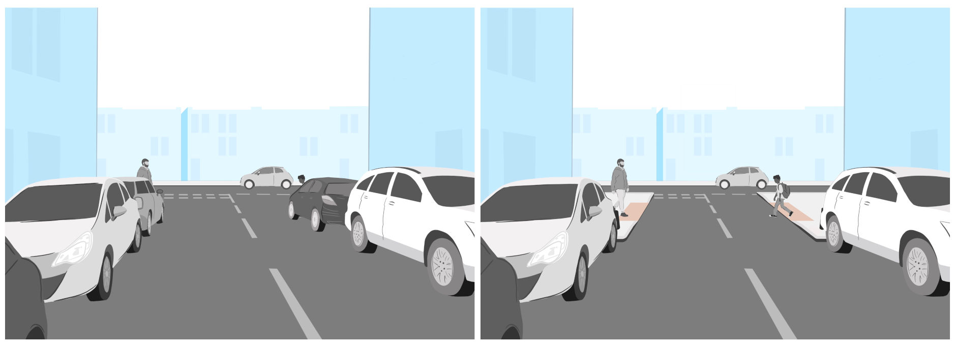
Very few continuous footways in Britain include features to achieve this narrowing effect. However, they are a relatively standard feature on Dutch exit constructions (as defined by the extent of the ramp on the side road, and other limits to the area that can be driven on).
On many streets such “build-out” areas (and their equivalent on continuous footway structures) might make a substantial difference to the length of time that a pedestrian is visible before any potential interaction with a vehicle. In many cases these build-out areas more than double the time before the crossing point (or drivable space) is reached. Crucially, pedestrians also have more time to observe approaching vehicles.
However, it is important to note that some of our detailed-study sites included build-outs or an equivalent narrowing of the drivable space, yet still failed to properly prioritise pedestrians. Therefore, we conclude that this feature is helpful, but that on its own it is not sufficient to ensure priority.
Dutch exit constructions typically also have a build-out area to account for situations where parking is allowed along the side of the carriageway of the main road. Figure 26 shows a simplified illustration of how such a feature would change the design of an ordinary British side road junction.

This second build-out area moves the end of the side road into the main carriageway. In the case of a continuous footway the position of the ramped transition to the main carriageway would be moved, tightening the turn required by entering vehicles.
Figure 27 shows the standard image of an exit construction included in the Dutch ASVV urban street design guide18, which can be seen to have both features. More details of this document are described in the literature review (see Section 3).

In our study of the effects of restricted visibility on driver behaviour we noted that these are complex. On the one hand, drivers may be more careful if it is obvious that they are emerging into a space where they cannot see oncoming pedestrians or vehicles, but on the other hand they may be less careful for the same reason.
This is a complex scenario to analyse, but in our observations we saw many situations in which individual drivers appeared to take little care in emerging into a space where they might have put pedestrians at risk. We also observed that drivers could often be seen to respond quickly when a potential collision arose. With these observations in mind, it can be argued that what matters is that drivers have as much opportunity as possible to see conflicting pedestrian movements. The section above recommended design options to improve visibility.
Some previous discussion around restricted visibility has focused on whether give-way markings should be placed further from the main carriageway, even if this means that drivers who stop at these markings cannot see oncoming vehicles. However, as noted in Section 7.4, in practice drivers rarely stopped at such markings – and they could often be seen to ignore their exact location.
The literature review established that Dutch exit constructions do not include any markings of priority. It also found that there is little certainty among experts that these markings, in Britain, provide any legal priority for pedestrians.
Minor changes in continuous footway design could be seen to substantially change whether or not a design produced an unambiguous continuation of the footway. It appears that the addition of only minor features, such as paint markings, can create an ambiguous effect – making it unclear what is footway and what is carriageway. Examples of such markings included triangular ramp markings, lines indicating parking restrictions, and give way markings.
It seems reasonable to conclude that a ‘real’ continuous footway effect will be weakened if paint markings associated with the carriageway are marked on the footway area.
It was clear from the study that drivers interpret such markings as only one of many indications of a need to give way. It seems reasonable to conclude that the provision of any such markings will have an insignificant effect on driver behaviour in any situation where it is already obvious that they are driving over a section of footway (although this should be kept under review where ‘real’ continuous footways are introduced). Therefore, any need to provide such markings may indicate the failure of a design to create an unambiguous continuation of the footway (with the consequent pedestrian priority).
This study does not have good evidence as to whether give-way markings provided on the carriageway, and encountered before a driver mounts a ramp onto a ‘real’ continuous footway, will have a substantial effect – although it indicates doubt that such markings provide legal priority to pedestrians. The inclination to give way to pedestrians should therefore be researched if examples of ‘real’ continuous footways are built.
It seems likely that there are many other factors, aside from the positioning of the lines themselves, which will be more important in determining where drivers stop their vehicles to await a gap in traffic (see Section 7.4).
Earlier we noted that the performance of continuous footways is likely to depend, at least in part, on low enough vehicle approach speeds.
This relates both to vehicles approaching from the side road and vehicles approaching on the main carriageway.
In practice, the physical constraints on speed in the side road need to be determined not only by the presence of more common speed-calming features (i.e. humps or an equivalent using vertical deflection), but also by the width of the carriageway. Appropriate design should imply to drivers that slow speeds are natural on the side road, and should make faster speeds physically difficult or impossible. It should be noted that Dutch exit constructions (where used over public streets) are only used at the transition between slow speed local access streets and urban through streets (see Section 8.6) – and that the local access streets are designed to be “self-explaining” to emphasise their low-speed function.
These conditions should also have an effect not just on drivers exiting the side road, but also on those entering, who may be much more likely to give way to pedestrians if they know that they are entering a low-speed environment than if they consider this an interruption to an ongoing faster journey.
Speeds on the main road also matter. For a continuous footway to work properly (in allowing drivers to give way to pedestrians) drivers must feel safe and comfortable slowing to a walking speed, or in stopping, as their vehicle approaches on the main carriageway.
The study noted that at many of the detailed-study sites there were few back-up options available for pedestrians crossing.
Blind and partially sighted people may sometimes choose to walk into a side road so that they can cross it at a safer or simpler point. In some situations, such an indent may be of only of a metre or two, but in other cases people walk much further into a side road. On some side streets the presence of parked vehicles makes it difficult or impossible for a blind or partially sighted pedestrian to cross in this way.
An inclusive approach (illustrated in Figure 28) would provide a backup option, allowing a pedestrian to cross within the side road if conditions at the junction are not adequate (noting that the ideal option would allow all pedestrians to cross at the junction).

Such a crossing point should be built so that parked vehicles cannot block it or obstruct the visibility or passage of those crossing, crossing distances are minimised, and kerbs on either side of the crossing are parallel. The design process should also consider how a blind or partially sighted pedestrian will find such a crossing point (for example, with an appropriate tactile feature).
Although unproven, arguments against using standard tactile paving styles and arrangements at continuous footways which provide unambiguous pedestrian priority, might be reasonable. This is based on the idea that the visual effect of standard tactile paving risks weakening the impression drivers are given that they are driving over an uninterrupted footway. However, that argument is only reasonable where pedestrian priority is unambiguous, vehicle speeds are extremely low, and most pedestrians cross without any interaction with a vehicle. Such conditions were not provided at any of the wider or busier side roads we studied. Therefore, we conclude that at these locations standard tactile paving in a standard layout should be provided.
Alternative arrangements for tactile paving were considered in the course of the project. These included situations where blister-style paving was used, but at some distance from the area that could be driven on. We also tried to understand whether an alternative style of paving (for example, of a corduroy type) might be used. It is possible that some of these options might have value, but novel arrangements could very easily be confusing or misleading. Alternatives to standard arrangements of blister-style paving could be trialled at sites providing unambiguous pedestrian priority (once these exist) – as part of work to determine how this affects their functioning. However, this should only happen as part of an organised research programme which seeks a nationally standardised approach (rather than by individual designers working separately).
For many blind and partially sighted people tactile paving only remains useful if it is used consistently on the streets and if it conveys very simple messages. Areas that lack kerbs can be particularly difficult to navigate (as noted elsewhere), meaning that tactile features become important for reasons other than safety. The increasing use of non-standard tactile paving arrangements, installed as part of efforts to provide continuous footways but differing from site to site, has the potential to create confusing conditions for blind and partially sighted pedestrians.
One important option, which should be researched further for use in these circumstances, would involve the provision of “guide line” tactile paving that long cane users, or those using the feeling in their feet, can follow over any larger open area (see Section 5.4). Specifications for this style of paving are provided in Chapter 6 of the Department for Transport’s “Guidance on the Use of Tactile Paving Surfaces”.19
Typical tactile paving materials may not be strong enough to withstand use in places that are driven over regularly. Current unavailability of suitably load bearing materials is not an appropriate reason to ignore the potential value of new arrangements.
We noted that some blind and partially sighted participants in this study commented on how difficult it was to access mobility training and that changes to streets could create what one called “a guessing game”. We understood that these problems had threatened them with complete exclusion from some streets. Clearly new layouts, however well intentioned, must not exclude anyone simply because unfamiliarity and the absence of any support to deal with changes. Designers must not assume that mobility training will be available locally or that it will be tailored to their design choices. Proactively addressing these issues is critical in terms of local authorities making “reasonable adjustments” under equality laws. Research on the level of local and national provision is needed.
While there are equivalents in places elsewhere, we have only found one country – the Netherlands – where an equivalent of a ‘real’ continuous footway can be seen as a standard and common feature, to be driven over when entering or exiting a public side street. The research evidences that these have been in use for decades.
We found good evidence of debates, in older informal Dutch literature, around how to make the priority of one driver over another as clear as possible on their range of junction designs. We found no accompanying debate about any problems for pedestrians.
In our literature review we established that it is Dutch national policy to ensure that local access streets and urban through streets20 are recognisable and that they are clearly distinguishable from each other. A range of features are used to create this effect, like changes in surfacing materials or the absence of any priority markings at junctions in the local access streets. The same national policy – on “Sustainable Safety” – rejects the use of designs which promote traffic flow on local access streets, and it is standard practice to discourage or prevent through traffic on these.
Exit constructions are used, within this system, as a standardised and recognisable gateway marking the transition point between one category of street and the other.
One key piece of Dutch research, looking at the safety of exit constructions, concluded that this gateway function and its role in area-wide safety – rather than conditions at the actual exit – were the most important reasons for the use of exit constructions in the Netherlands (see the literature review for details).
The effectiveness and safety of Dutch exit constructions is likely linked to their standardised design, and their use in these specific well-defined well-recognised locations.
Whilst street hierarchies do exist in the Britain, distinctions are very much more blurred than in this Dutch system.
Current British attempts to use continuous footways also appear to be being compromised by a wish to accommodate high levels of vehicle use and traffic flow, yet the need to change conditions to improve the priority of pedestrians is accepted. Here there is no nationally agreed (and effectively used) set of design principles, nor any equivalently comprehensive programme, for reforming streets to this effect.
It has been suggested that the use of side-road zebra crossings may provide an alternative tool for prioritising pedestrian passage across the end of side roads. However we heard that zebra crossings do not work well for blind and partially sighted pedestrians. A recent small scale on street trial of these, at two low-risk sites, recorded improved priority for pedestrians but also significant levels of non-compliance21. In any case it seems likely that their success or failure would depend on many of the same factors we report as significant for ‘real’ continuous footways.
Although a significant task, there could be major benefits in a refocusing of the overall philosophy of transport planning in Britain. This could make the application of ‘real’ continuous footways, and other pedestrian focused changes, much more straightforward. While a national approach might be most powerful it may also be possible to start this work with a focus on smaller areas – such as on a single city.
The Dutch Sustainable Safety system would be one obvious source of inspiration for this – even if their designs were found to include some failings in terms of inclusion, which is something worthy of further research – but there may be others.
Following on from the previous section’s discussion on the complex themes and findings arising, the project’s main conclusions and recommendations are summarised, in brief, below.
There is a high degree of confusion over what is and what is not a continuous footway. This complicates any discussion over the effectiveness of continuous footways, and the resulting lack of design standardisation has real-world effects.
Most of the infrastructure currently being called a “continuous footway”, or which attempts to continue the footway over the end of wider side roads in Britain, does not successfully prioritise pedestrians over vehicles. This has implications for inclusion.
To some extent we could see that designers and organisations representing disabled people might share overall objectives, while being divided into two different camps, with a lack of connection or knowledge-sharing being a significant problem. It was evident that there is a real risk that opposition to more radical change, from those who are – not unreasonably – afraid that their needs are being ignored, may help entrench the status quo of traffic dominance and low pedestrian priority. This can make good quality changes less likely.
It is a problem for blind and partially sighted people that there has been a rise in the number of locations where the distinction between footway and carriageway is blurred, or where the transition from one to the other is indistinct. This has the potential to increase fear, not only at these locations but much more widely – as the sense that footways are (relatively) safe spaces is eroded. The lack of tactile paving, to warn of a kerb-free transition into a space which drivers may be treating as part of the carriageway, is a problem with many of the designs that are currently being called continuous footways in Britain.
At most continuous footways in Britain the ramps used, if any, provide much less of a constraint on speeds than those used as standard at Dutch “exit constructions”. The height of the ramp is as important as its gradient, but there is little mention of ramp height in literature discussing continuous footway design.
At continuous footways simultaneous two-way vehicle movement creates significant additional challenges and risks to pedestrians.
Narrowing the space available for driving over the footway helps to transform safety, comfort and convenience for pedestrians. In contrast to arrangements seen in other countries, few continuous footways in Britain include features to do this.
The traffic volumes and vehicle speeds on the carriageways approaching a continuous footway – on both the main road and the side road – affect the degree to which they are likely to prioritise pedestrians.
The increasing use of non-standard tactile paving arrangements, installed as part of efforts to provide continuous footways but differing from site to site, is likely to create confusing conditions for blind and partially sighted pedestrians.
While this work points to problems with some new infrastructure it also highlights that more typical streets exclude people. It points to a lack of evidence about the success of ‘real’ continuous footways, but suggests these should be tested (provided they are designed so as to provide an unambiguous continuation of the footway, with additional features to limit vehicle speeds and paths, and which have an appropriately low level of vehicle use).
As a minimum alteration, a standard arrangement of blister-style tactile paving should be retro-fitted at sites where it appears to pedestrians as if the footway continues while at the same time it is predictable that they could meet a driver who is behaving as if on a carriageway.
The clearest response to the current confusion about the term continuous footways would be to standardise this – applying it only to those ‘real’ continuous footways where an unambiguous continuation of the footway exists.
In the longer term, it seems likely that the standardisation of continuous footways is necessary to create predictable driver and pedestrian behaviours, and work to achieve this should be undertaken, with proper trials of ‘real’ continuous footways. The use of recognisable, standardised (and effectively steep and high) ramps should be a key part of this.
Those interested in progress and on improving conditions for pedestrians, should build allegiances, connections, and real in-depth knowledge, lessening the divide between designers focused on implementing changes and organisations representing disabled people concerned about them.
It is essential that designers involved in providing changes to side road layouts should understand the key factors making navigation safe or dangerous, or easy or difficult, for blind and partially sighted people.
Where vehicle speeds and volumes cannot be sufficiently reduced to make a continuous footway suitable, then a good quality “raised side road entry treatment” may be more inclusive than a compromised continuous footway.
Continuous footways should only be used where wider conditions make them suitable, and specifically where wider design creates traffic volumes and speeds on the carriageways approaching the structure which are low enough.
A useful rule of thumb will be that it is necessary to bring vehicles to a walking speed, using physical design features, before they cross a continuous footway structure, whether or not pedestrians are present.
The inclusion in design guidance of details about ramp design, including ramp height, will be important. If ‘real’ continuous footways are to be constructed, and are to successfully prioritise pedestrians, it is likely that these should include an appropriately steep and high ramp, of a standardised and recognisable design.
Questions relating to the use of appropriately high and steep ramps, and the potential that councils are sued for damage to vehicles if they use these, should be resolved.
In designing future continuous footways (and footway crossovers) constraints on vehicle path, ensuring tight turns and sufficiently narrow spaces, should be used to slow any vehicles which are able to negotiate ramps without needing to slow to walking speed.
Physical constraints should be used to prevent simultaneous two-way vehicle movement. These should also narrow the area of footway available for driving over, creating situations in which pedestrians can be seen for as long as possible before they reach this area.
Alternative tactile paving arrangements – for use at those ‘real’ continuous footways and wider/equivalent footway crossovers which can be shown to provide unambiguous pedestrian priority – should be trialled, to research whether they have any value, as part of an organised programme which seeks a nationally standardised approach (rather than by individual designers working separately).
Given that…
Most attempts to use continuous footways in Britain are compromised by a wish to accommodate high levels of vehicle use and traffic flow
The need to change conditions to improve the priority of pedestrians is accepted (irrespective of the use of continuous footways)
There is no nationally agreed set of design principles or programme for reforming streets being effectively implemented in a way that points to a future in which pedestrians are prioritised
‘Real’ continuous footways (as exit constructions) are long-established and very common feature on Dutch streets, but not elsewhere, with these used as an integral part of a national programme reforming how streets work
…then this research suggests that the future use of continuous footways – other than on small lanes and accesses – may need to take place as part of an equivalently radical plan for the reform of how streets work more generally.